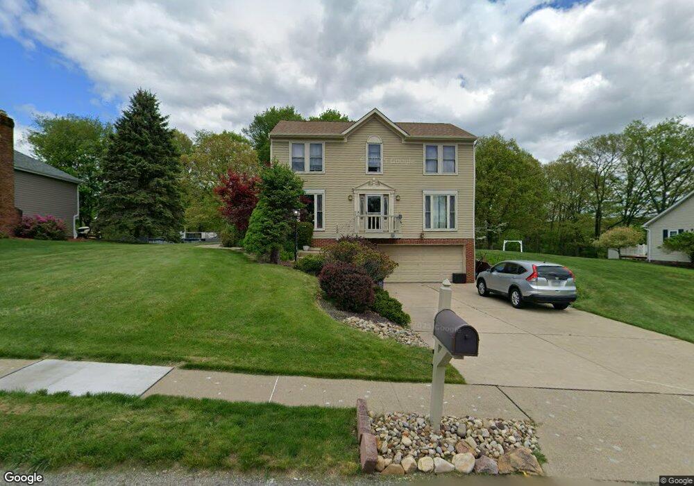
106 Pointe West Dr Mc Donald, PA 15057
Estimated Value: $415,000 - $490,000
4
Beds
3
Baths
1,956
Sq Ft
$229/Sq Ft
Est. Value
About This Home
This home is located at 106 Pointe West Dr, Mc Donald, PA 15057 and is currently estimated at $447,615, approximately $228 per square foot. 106 Pointe West Dr is a home located in Allegheny County with nearby schools including West Allegheny Senior High School.
Ownership History
Date
Name
Owned For
Owner Type
Purchase Details
Closed on
Feb 27, 2023
Sold by
Chavda Mital R and Syed Zahurul H
Bought by
Syed Chavda Living Trust and Chavda
Current Estimated Value
Purchase Details
Closed on
May 31, 2012
Sold by
Balint Scott E
Bought by
Chavda Mital R and Syed Zahurul H
Home Financials for this Owner
Home Financials are based on the most recent Mortgage that was taken out on this home.
Original Mortgage
$192,000
Interest Rate
3.9%
Mortgage Type
New Conventional
Create a Home Valuation Report for This Property
The Home Valuation Report is an in-depth analysis detailing your home's value as well as a comparison with similar homes in the area
Home Values in the Area
Average Home Value in this Area
Purchase History
| Date | Buyer | Sale Price | Title Company |
|---|---|---|---|
| Chavda Mital R | $240,000 | -- | |
| Syed Chavda Living Trust | -- | -- |
Source: Public Records
Mortgage History
| Date | Status | Borrower | Loan Amount |
|---|---|---|---|
| Previous Owner | Chavda Mital R | $192,000 |
Source: Public Records
Tax History Compared to Growth
Tax History
| Year | Tax Paid | Tax Assessment Tax Assessment Total Assessment is a certain percentage of the fair market value that is determined by local assessors to be the total taxable value of land and additions on the property. | Land | Improvement |
|---|---|---|---|---|
| 2025 | $6,057 | $228,300 | $40,700 | $187,600 |
| 2024 | $6,057 | $228,300 | $40,700 | $187,600 |
| 2023 | $6,057 | $228,300 | $40,700 | $187,600 |
| 2022 | $6,057 | $228,300 | $40,700 | $187,600 |
| 2021 | $1,080 | $228,300 | $40,700 | $187,600 |
| 2020 | $6,057 | $228,300 | $40,700 | $187,600 |
| 2019 | $5,890 | $228,300 | $40,700 | $187,600 |
| 2018 | $1,050 | $222,000 | $40,700 | $181,300 |
| 2017 | $5,890 | $222,000 | $40,700 | $181,300 |
| 2016 | $1,050 | $222,000 | $40,700 | $181,300 |
| 2015 | $1,050 | $222,000 | $40,700 | $181,300 |
| 2014 | $5,890 | $222,000 | $40,700 | $181,300 |
Source: Public Records
Map
Nearby Homes
- 103 Hollyberry Cir
- 146 Mcvey St
- 845 Wall St
- 100 Hill Place Dr
- 319 Dupont Dr
- 1015 Granite Dr
- 1103 Hoffman Dr
- 809 Station St
- Lot 4 McVey Street Extension
- Lot 3 McVey Street Extension
- Lot 3166 Robinson Run Rd
- 7712 Noblestown Rd
- 0 McVey St Extension Unit 1692515
- 205 Spring St
- 238 State St W
- 4401 Battle Ridge Rd
- Carlisle Plan at Stonegate
- Tucson Plan at Stonegate
- Hoover Plan at Stonegate
- Waterloo Plan at Stonegate
- 106 Pointe Dr W
- 108 Pointe West Dr
- 104 Pointe West Dr
- 107 Pointe West Dr
- 109 Pointe West Dr
- 105 Pointe West Dr
- 110 Pointe West Dr
- 102 Pointe West Dr
- 103 Pointe West Dr
- 103 Pointe Dr W
- 111 Pointe West Dr
- 112 Pointe West Dr
- 100 Pointe West Dr
- 112 Pointe Dr W
- 113 Pointe West Dr
- 7516 Noblestown Rd
- 101 Pointe West Dr
- 7526 Noblestown Rd
- 114 Pointe West Dr
- 115 Pointe West Dr