Estimated Value: $98,790 - $160,000
--
Bed
2
Baths
1,204
Sq Ft
$115/Sq Ft
Est. Value
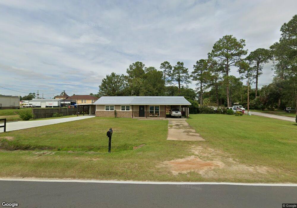
About This Home
This home is located at 106 Radio Station Rd, Alma, GA 31510 and is currently estimated at $138,698, approximately $115 per square foot. 106 Radio Station Rd is a home located in Bacon County with nearby schools including Bacon County Primary School, Bacon County Elementary School, and Bacon County Middle School.
Ownership History
Date
Name
Owned For
Owner Type
Purchase Details
Closed on
Sep 25, 2024
Sold by
Swindle James Barry
Bought by
Smith Jo Ann
Current Estimated Value
Purchase Details
Closed on
Aug 11, 2021
Sold by
Beck Miriam Donnette
Bought by
Beck Stanley Ray
Purchase Details
Closed on
Nov 17, 1994
Sold by
Carter E L
Bought by
Smart James D
Create a Home Valuation Report for This Property
The Home Valuation Report is an in-depth analysis detailing your home's value as well as a comparison with similar homes in the area
Home Values in the Area
Average Home Value in this Area
Purchase History
| Date | Buyer | Sale Price | Title Company |
|---|---|---|---|
| Smith Jo Ann | -- | -- | |
| Beck Stanley Ray | -- | -- | |
| Swindle James Barry | -- | -- | |
| Smith Joann | $35,000 | -- | |
| Smart James D | -- | -- |
Source: Public Records
Tax History Compared to Growth
Tax History
| Year | Tax Paid | Tax Assessment Tax Assessment Total Assessment is a certain percentage of the fair market value that is determined by local assessors to be the total taxable value of land and additions on the property. | Land | Improvement |
|---|---|---|---|---|
| 2024 | $1,233 | $39,120 | $3,000 | $36,120 |
| 2023 | $1,199 | $36,160 | $2,200 | $33,960 |
| 2022 | $345 | $18,000 | $2,200 | $15,800 |
| 2021 | $691 | $17,920 | $2,200 | $15,720 |
| 2020 | $665 | $16,497 | $2,000 | $14,497 |
| 2019 | $665 | $16,497 | $2,000 | $14,497 |
| 2018 | $654 | $16,252 | $2,000 | $14,252 |
| 2017 | $654 | $16,252 | $2,000 | $14,252 |
| 2016 | $654 | $16,252 | $2,000 | $14,252 |
| 2015 | $629 | $15,604 | $1,803 | $13,802 |
| 2014 | $617 | $15,604 | $1,803 | $13,802 |
| 2013 | $617 | $15,110 | $1,802 | $13,308 |
Source: Public Records
Map
Nearby Homes
- 403 S Ware St
- 117 Grace Loop Unit 1
- 118 Grace Loop Unit 1
- 122 Grace Loop Unit 1
- 611 S Bead St
- 314 W 16th St
- 9TH E 417
- 113 Brite Blue Dr
- 166 Grace Loop Unit 1
- 198 Meadow Rd
- 907 N Pierce St
- 401 Lee St
- 224 Meadow Rd
- 118 Morris Dr
- 0 Oriole Rd Unit 1654653
- 0 Oriole Rd Unit 10543585
- 0 Oriole Rd Unit 25773381
- 0 Oriole Rd Unit 160930
- 1109 W 4th Street Extension
- 1348 U S 1
- 0 Radio Station Rd Unit 7519477
- 0 Radio Station Rd Unit 121854
- 0 Radio Station Rd Unit 123126
- 829 S Ware St
- 202 Radio Station Rd
- 827 S Ware St
- 1006 S Pierce St
- 204 Radio Station Rd
- 825 S Ware St
- 826 S Ware St
- 0000 S Pierce St
- 824 S Ware St
- 102 Crosby Rd
- 206 Radio Station Rd
- 104 Floyd St
- 823 S Ware St
- 822 S Ware St
- 905 S Wayne St
- 303 Radio Station Rd
- 819 S Ware St