
Seller's Agent in 2025
Ashley Rioux
RE/MAX
(603) 315-8790
7 in this area
106 Total Sales

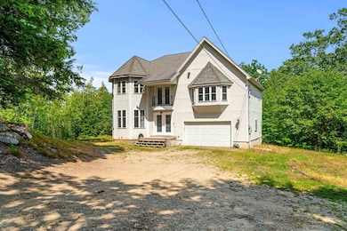
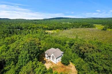

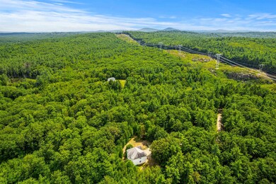
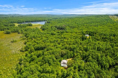
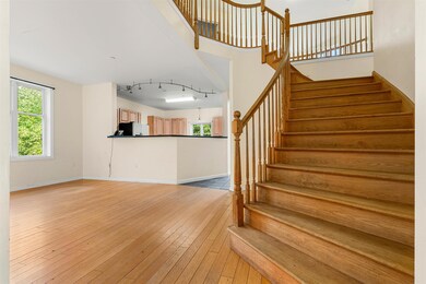
*Sellers are motivated* Discover unparalleled privacy and natural beauty with this remote single family home set on over 30 acres of pristine land in the charming town of Dunbarton. This spacious residence features four bedrooms and three bathrooms offering ample room for family and guests. Inside, cathedral ceilings and an open-concept floor plan create a bright, airy atmosphere perfect for both relaxing and entertaining. The walk-out basement provides exciting potential for additional living space, whether as a recreation room, in-law suite, or home office. While the home offers solid bones and a desirable layout, it does need some cosmetic updates giving buyers the perfect opportunity to bring their own finishing touches and make it truly their own. With extensive road frontage and the possibility of subdividing additional lots (buyers to perform all due diligence), this property presents a rare opportunity for future expansion or investment. Surrounded by nature and tucked away from the hustle and bustle, it’s an ideal retreat for those seeking peace and seclusion. Located in a quaint New England town known for its welcoming community and scenic landscapes, this home is a true gem waiting to be discovered.
Last Agent to Sell the Property
RE/MAX Synergy Brokerage Phone: 603-315-8790 License #069465 Listed on: 08/17/2025
| Date | Type | Sale Price | Title Company |
|---|---|---|---|
| Warranty Deed | $585,000 | -- | |
| Deed | $300,000 | -- |
| Date | Status | Loan Amount | Loan Type |
|---|---|---|---|
| Open | $585,000 | New Conventional | |
| Previous Owner | $249,000 | Unknown | |
| Previous Owner | $240,000 | Purchase Money Mortgage |
| Date | Event | Price | List to Sale | Price per Sq Ft |
|---|---|---|---|---|
| 10/03/2025 10/03/25 | Sold | $585,000 | -2.3% | $236 / Sq Ft |
| 08/17/2025 08/17/25 | For Sale | $599,000 | -- | $241 / Sq Ft |
| Year | Tax Paid | Tax Assessment Tax Assessment Total Assessment is a certain percentage of the fair market value that is determined by local assessors to be the total taxable value of land and additions on the property. | Land | Improvement |
|---|---|---|---|---|
| 2025 | $11,219 | $686,568 | $162,068 | $524,500 |
| 2024 | $10,356 | $392,587 | $88,287 | $304,300 |
| 2023 | $10,038 | $392,587 | $88,287 | $304,300 |
| 2022 | $9,022 | $392,587 | $88,287 | $304,300 |
| 2021 | $9,190 | $392,587 | $88,287 | $304,300 |
| 2020 | $8,749 | $392,678 | $88,378 | $304,300 |
| 2018 | $7,139 | $316,862 | $68,862 | $248,000 |
| 2017 | $8,113 | $316,795 | $68,795 | $248,000 |
| 2016 | $7,599 | $316,907 | $68,907 | $248,000 |
| 2015 | $7,473 | $316,795 | $68,795 | $248,000 |
| 2014 | $6,853 | $324,172 | $68,772 | $255,400 |
| 2013 | $6,814 | $324,315 | $68,915 | $255,400 |
Seller's Agent in 2025
Ashley Rioux
RE/MAX
(603) 315-8790
7 in this area
106 Total Sales
J
Buyer's Agent in 2025
Jeremy Wirths
EXP Realty
(207) 329-6976
1 in this area
17 Total Sales
Source: PrimeMLS
MLS Number: 5056954
APN: DUNB-000004-000002-000005-D000000
Disclaimer: Certain information contained herein is derived from information provided by parties other than Homes.com. All information provided is deemed reliable, but is not guaranteed to be accurate and should be independently verified.
![]() Copyright 2026 PrimeMLS, Inc. All rights reserved. This information is deemed reliable, but not guaranteed. The data relating to real estate displayed on this display comes in part from the IDX Program of PrimeMLS. The information being provided is for consumers’ personal, non-commercial use and may not be used for any purpose other than to identify prospective properties consumers may be interested in purchasing.
Copyright 2026 PrimeMLS, Inc. All rights reserved. This information is deemed reliable, but not guaranteed. The data relating to real estate displayed on this display comes in part from the IDX Program of PrimeMLS. The information being provided is for consumers’ personal, non-commercial use and may not be used for any purpose other than to identify prospective properties consumers may be interested in purchasing.
Ask me questions while you tour the home.