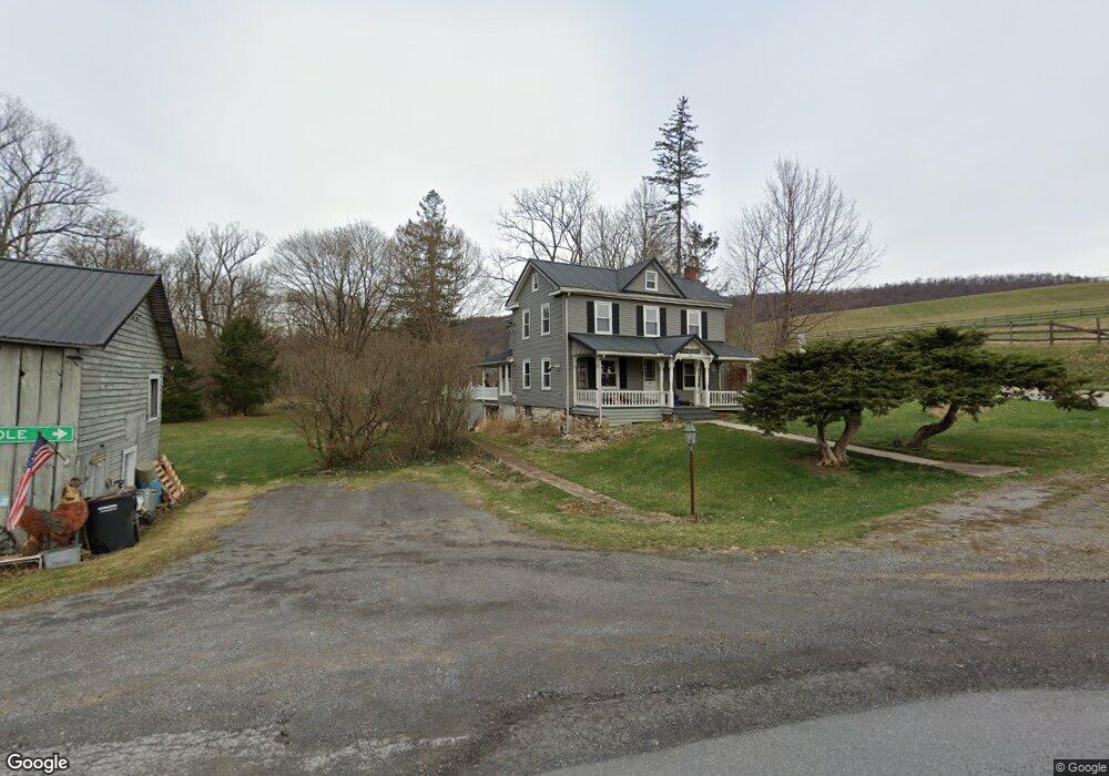
106 Stevenson Rd Port Matilda, PA 16870
Patton NeighborhoodEstimated Value: $457,406 - $691,000
4
Beds
2
Baths
1,849
Sq Ft
$294/Sq Ft
Est. Value
About This Home
This home is located at 106 Stevenson Rd, Port Matilda, PA 16870 and is currently estimated at $543,135, approximately $293 per square foot. 106 Stevenson Rd is a home located in Centre County with nearby schools including Park Forest Elementary School, Park Forest Middle School, and State College Area High School.
Ownership History
Date
Name
Owned For
Owner Type
Purchase Details
Closed on
Jan 20, 2017
Sold by
Savage William V
Bought by
Savage William V
Current Estimated Value
Home Financials for this Owner
Home Financials are based on the most recent Mortgage that was taken out on this home.
Original Mortgage
$100,000
Outstanding Balance
$82,503
Interest Rate
4.16%
Mortgage Type
New Conventional
Estimated Equity
$460,632
Purchase Details
Closed on
May 3, 2001
Bought by
Mickey Carol E and Mickey Mickey
Create a Home Valuation Report for This Property
The Home Valuation Report is an in-depth analysis detailing your home's value as well as a comparison with similar homes in the area
Home Values in the Area
Average Home Value in this Area
Purchase History
| Date | Buyer | Sale Price | Title Company |
|---|---|---|---|
| Savage William V | -- | None Available | |
| Mickey Carol E | $70,000 | -- |
Source: Public Records
Mortgage History
| Date | Status | Borrower | Loan Amount |
|---|---|---|---|
| Open | Savage William V | $100,000 |
Source: Public Records
Tax History Compared to Growth
Tax History
| Year | Tax Paid | Tax Assessment Tax Assessment Total Assessment is a certain percentage of the fair market value that is determined by local assessors to be the total taxable value of land and additions on the property. | Land | Improvement |
|---|---|---|---|---|
| 2025 | $4,336 | $76,785 | $26,840 | $49,945 |
| 2024 | $4,990 | $76,785 | $26,840 | $49,945 |
| 2023 | $4,990 | $76,785 | $26,840 | $49,945 |
| 2022 | $3,948 | $76,785 | $26,840 | $49,945 |
| 2021 | $3,948 | $76,785 | $26,840 | $49,945 |
| 2020 | $3,948 | $76,785 | $26,840 | $49,945 |
| 2019 | $2,760 | $76,785 | $26,840 | $49,945 |
| 2018 | $3,827 | $76,785 | $26,840 | $49,945 |
| 2017 | $4,670 | $76,785 | $26,840 | $49,945 |
| 2016 | -- | $62,240 | $12,295 | $49,945 |
| 2015 | -- | $62,240 | $12,295 | $49,945 |
| 2014 | -- | $73,245 | $23,300 | $49,945 |
Source: Public Records
Map
Nearby Homes
- 113 Manhasset Dr
- 190 Michael Rd
- 112 Montauk Cir
- 209 Shadow Hawk Ln
- 112 Harvard Rd
- 111 Harvard Rd
- Lot 2 Julian Pike
- 111 Wildernest Ln
- 95 Greenmeadow Ln
- 107 Wildernest Ln
- 144 Kenley Ct Unit 144
- 0 S Eagle Valley Rd
- 1340 Railroad Ave
- 108 Heiskel Dr
- 2074 Mary Ellen Ln
- 1918 Weaver St Unit 1
- 257 Oakwood Ave
- 291 Oakley Dr
- 1952 Highland Dr
- 1832 Waddle Rd
- 146 Stevenson Rd
- 187 Stevenson Rd
- 177 Stevenson Rd
- 199 Stevenson Rd
- 212 Stevenson Rd
- 219 Stevenson Rd
- 4414 Buffalo Run Rd
- 4165 Buffalo Run Rd
- 257 Stevenson Rd
- 4413 Buffalo Run Rd
- 121 Rhapsody Dr
- 150 Kimber Lee Dr
- 124 Rhapsody Dr
- 115 Chippendale Ln
- 210 Kimber Lee Dr
- 133 Chippendale Ln
- Lot 8 Kimber Lee Dr
- 246 Kimber Lee Dr
- 100 Kensington Dr
- 4510 Buffalo Run Rd