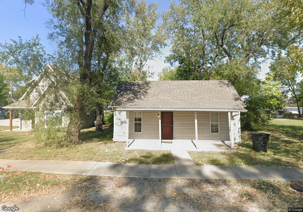
106 SW 10th St Oak Grove, MO 64075
Estimated Value: $121,000 - $175,000
2
Beds
1
Bath
784
Sq Ft
$185/Sq Ft
Est. Value
About This Home
This home is located at 106 SW 10th St, Oak Grove, MO 64075 and is currently estimated at $145,165, approximately $185 per square foot. 106 SW 10th St is a home located in Jackson County with nearby schools including Oak Grove Primary School, Oak Grove Elementary School, and Oak Grove Middle School.
Ownership History
Date
Name
Owned For
Owner Type
Purchase Details
Closed on
Dec 28, 2018
Sold by
Hazy Investments Llc
Bought by
B P P Investments Llc
Current Estimated Value
Purchase Details
Closed on
Mar 1, 2006
Sold by
Sudduth Ronald W and Sudduth Wanda R
Bought by
Haase Jonathan and Haase Casey
Home Financials for this Owner
Home Financials are based on the most recent Mortgage that was taken out on this home.
Original Mortgage
$37,000
Interest Rate
7.5%
Mortgage Type
Purchase Money Mortgage
Purchase Details
Closed on
Oct 3, 1997
Sold by
Sudduth Marvin H and Sudduth Carolyn E
Bought by
Sudduth Ronald W and Sudduth Wanda
Home Financials for this Owner
Home Financials are based on the most recent Mortgage that was taken out on this home.
Original Mortgage
$24,000
Interest Rate
8%
Mortgage Type
Seller Take Back
Create a Home Valuation Report for This Property
The Home Valuation Report is an in-depth analysis detailing your home's value as well as a comparison with similar homes in the area
Home Values in the Area
Average Home Value in this Area
Purchase History
| Date | Buyer | Sale Price | Title Company |
|---|---|---|---|
| B P P Investments Llc | -- | Kansas City Title Inc | |
| Haase Jonathan | -- | First American Title Ins Co | |
| Sudduth Ronald W | -- | -- |
Source: Public Records
Mortgage History
| Date | Status | Borrower | Loan Amount |
|---|---|---|---|
| Previous Owner | Haase Jonathan | $37,000 | |
| Previous Owner | Sudduth Ronald W | $24,000 |
Source: Public Records
Tax History Compared to Growth
Tax History
| Year | Tax Paid | Tax Assessment Tax Assessment Total Assessment is a certain percentage of the fair market value that is determined by local assessors to be the total taxable value of land and additions on the property. | Land | Improvement |
|---|---|---|---|---|
| 2025 | $1,124 | $10,302 | $4,444 | $5,858 |
| 2024 | $1,113 | $14,465 | $3,264 | $11,201 |
| 2023 | $1,113 | $14,465 | $3,196 | $11,269 |
| 2022 | $657 | $7,790 | $1,439 | $6,351 |
| 2021 | $642 | $7,790 | $1,439 | $6,351 |
| 2020 | $658 | $7,770 | $1,439 | $6,331 |
| 2019 | $626 | $7,770 | $1,439 | $6,331 |
| 2018 | $519 | $6,763 | $1,253 | $5,510 |
| 2017 | $519 | $6,763 | $1,253 | $5,510 |
| 2016 | $522 | $6,593 | $798 | $5,795 |
| 2014 | $446 | $5,624 | $1,157 | $4,467 |
Source: Public Records
Map
Nearby Homes
- 704 SW Clinton St
- 1705 Locust St
- 1312 SW Clinton St
- 508 SE 12th St
- TBD SW 5th St
- 1501 SW Stonewall Dr
- 1700 SW Stonewall Dr
- 1606 SW Stonewall Dr
- 303 SW 17th St
- 1108 SE Oak Ridge Dr
- 1106 SE Chelsey Ln
- 801 SE 13th St
- 1001 SW Powell Dr
- 1212 SW 5th St
- 1106 SW 10th St
- 509 SE 20th St
- 113 N Austin St
- 202 SW 21st St
- 400 SW Powell Dr
- 1407 SE Hillside Dr