Estimated Value: $326,416 - $345,000
4
Beds
4
Baths
2,632
Sq Ft
$128/Sq Ft
Est. Value
About This Home
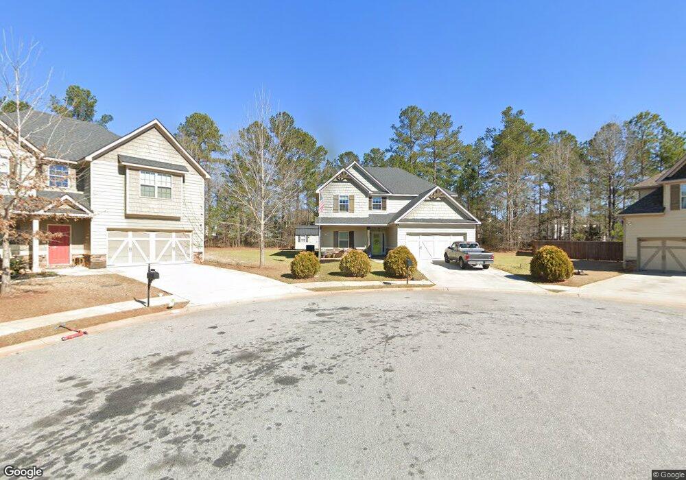
This home is located at 106 Wayland Cir, Perry, GA 31069 and is currently estimated at $337,354, approximately $128 per square foot. 106 Wayland Cir is a home located in Houston County with nearby schools including Langston Road Elementary School, Mossy Creek Middle School, and Perry High School.
Ownership History
Date
Name
Owned For
Owner Type
Purchase Details
Closed on
Mar 31, 2022
Sold by
Lynn Koske Amy
Bought by
Koske Michael Wade
Current Estimated Value
Purchase Details
Closed on
Oct 13, 2021
Sold by
Regions Bank
Bought by
Edgar Hughston Builder Inc
Purchase Details
Closed on
Dec 22, 2016
Bought by
Suchma Amy Lynn and Koske Michael Wade
Home Financials for this Owner
Home Financials are based on the most recent Mortgage that was taken out on this home.
Original Mortgage
$217,171
Interest Rate
4.03%
Mortgage Type
New Conventional
Create a Home Valuation Report for This Property
The Home Valuation Report is an in-depth analysis detailing your home's value as well as a comparison with similar homes in the area
Home Values in the Area
Average Home Value in this Area
Purchase History
| Date | Buyer | Sale Price | Title Company |
|---|---|---|---|
| Koske Michael Wade | -- | None Listed On Document | |
| Edgar Hughston Builder Inc | -- | None Listed On Document | |
| Edgar Hughston Builder Inc | -- | None Available | |
| Suchma Amy Lynn | $215,000 | -- |
Source: Public Records
Mortgage History
| Date | Status | Borrower | Loan Amount |
|---|---|---|---|
| Previous Owner | Suchma Amy Lynn | $217,171 |
Source: Public Records
Tax History
| Year | Tax Paid | Tax Assessment Tax Assessment Total Assessment is a certain percentage of the fair market value that is determined by local assessors to be the total taxable value of land and additions on the property. | Land | Improvement |
|---|---|---|---|---|
| 2025 | $4,152 | $126,320 | $10,000 | $116,320 |
| 2024 | $4,694 | $127,760 | $10,000 | $117,760 |
| 2023 | $4,633 | $125,240 | $10,000 | $115,240 |
| 2022 | $2,552 | $111,000 | $10,000 | $101,000 |
| 2021 | $2,242 | $97,000 | $10,000 | $87,000 |
| 2020 | $2,070 | $89,120 | $11,600 | $77,520 |
| 2019 | $2,070 | $89,120 | $11,600 | $77,520 |
| 2018 | $1,911 | $82,240 | $11,600 | $70,640 |
| 2017 | $1,875 | $80,640 | $10,000 | $70,640 |
Source: Public Records
Map
Nearby Homes
- 216 Dog Fennel Ln
- 108 Dog Fennel Ln
- 215 Goldenrod Trail
- 122 Blue Dunn Cir
- 104 Goldenrod Trail
- 207 Golden Rod Trail
- 207 Goldenrod Trail
- 133 W River Cane Run
- 104 Black Birch Rd Unit 84G
- 104 Black Birch Rd
- 207 Bald Cypress Dr Unit 37G
- 207 Bald Cypress Dr
- 209 Bald Cypress Dr Unit 38G
- 209 Bald Cypress Dr
- 211 Bald Cypress Dr Unit 39G
- 211 Bald Cypress Dr
- 213 Bald Cypress Dr
- 213 Bald Cypress Dr Unit 40G
- 102 Gallberry Ln Unit 53G
- 215 Bald Cypress Dr Unit 41G
- 105 Wayland Cir
- 104 Wayland Cir
- 103 Wayland Cr
- 108 E River Cane Run Unit 10
- 110 E River Cane Run
- 110 E River Cane Run Unit 34
- 110 E River Cane Run Unit 11
- 106 E River Cane Run
- 106 E River Cane Run Unit 9
- 300 Dog Fennel Ln
- 220 Dog Fennel Ln
- 304 Dog Fennel Ln Unit 306
- 304 Dog Fennel Ln
- 112 E River Cane Run Unit 12
- 308 Dog Fennel Ln Unit 305
- 308 Dog Fennel Ln
- 218 Dog Fennel Ln Unit 314
- 218 Dog Fennel Ln
- 104 E River Cane Run
- 104 E River Cane Run Unit 8
Your Personal Tour Guide
Ask me questions while you tour the home.