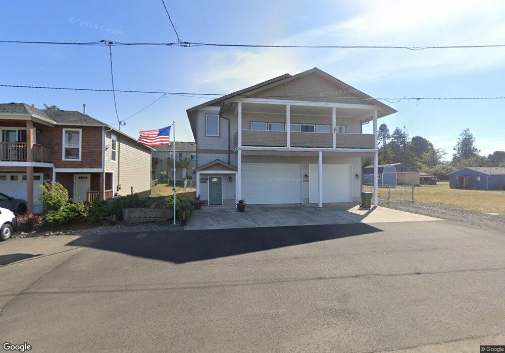
1060 4th Ave Hammond, OR 97121
Estimated Value: $561,000 - $768,000
4
Beds
3
Baths
2,520
Sq Ft
$265/Sq Ft
Est. Value
About This Home
This home is located at 1060 4th Ave, Hammond, OR 97121 and is currently estimated at $668,646, approximately $265 per square foot. 1060 4th Ave is a home with nearby schools including Warrenton Grade School, Warrenton High School, and Anchor Christian Academy.
Ownership History
Date
Name
Owned For
Owner Type
Purchase Details
Closed on
Mar 19, 2014
Sold by
Malley Patrick O and Malley Patrick R O
Bought by
Froembling Les and Froembling Diana
Current Estimated Value
Home Financials for this Owner
Home Financials are based on the most recent Mortgage that was taken out on this home.
Original Mortgage
$20,000
Interest Rate
4.18%
Mortgage Type
Purchase Money Mortgage
Purchase Details
Closed on
Oct 4, 2012
Sold by
Omalley Sharon and Omalley Sharon D
Bought by
Omalley Patrick and Omalley Patrick R
Create a Home Valuation Report for This Property
The Home Valuation Report is an in-depth analysis detailing your home's value as well as a comparison with similar homes in the area
Purchase History
| Date | Buyer | Sale Price | Title Company |
|---|---|---|---|
| Froembling Les | $50,000 | Pacific Title Company | |
| Omalley Patrick | -- | None Available |
Source: Public Records
Mortgage History
| Date | Status | Borrower | Loan Amount |
|---|---|---|---|
| Closed | Froembling Les | $20,000 |
Source: Public Records
Tax History
| Year | Tax Paid | Tax Assessment Tax Assessment Total Assessment is a certain percentage of the fair market value that is determined by local assessors to be the total taxable value of land and additions on the property. | Land | Improvement |
|---|---|---|---|---|
| 2025 | $4,080 | $306,635 | -- | -- |
| 2024 | $3,960 | $297,705 | -- | -- |
| 2023 | $3,830 | $289,035 | $0 | $0 |
| 2022 | $3,766 | $280,618 | $0 | $0 |
| 2021 | $3,709 | $272,445 | $0 | $0 |
| 2020 | $3,623 | $264,511 | $0 | $0 |
| 2019 | $3,531 | $256,808 | $0 | $0 |
Source: Public Records
Map
Nearby Homes
- 1175 Pacific Dr
- 1009 King Salmon Place
- 1880 1st Ave
- 472 7th Ave
- 448 Pacific Dr
- 0 NW Warrenton Dr Unit 185045184
- 676 NW 9th St
- 701 NW Warrenton Dr Unit 13
- 701 NW Warrenton Dr
- 701 NW Warrenton Dr Unit 28
- 701 NW Warrenton Dr #28
- 15 NW 6th Place
- 101 SW Juniper Ave
- 0 NW Date Ave
- 47 SW Gardenia Ave
- 0 NW Cedar Ave
- 1015 SW 2nd St
- 332 SW Kalmia Ave
- 90 NW Birch Ave
- 0 NW Birch Ave
- TL4300 4th Ave
- 1030 4th Ave
- 1055 5th Ave
- 1020 4th Ave
- 1020 4th Ave Unit 1040
- 1055 5th St
- 1045 5th Ave
- 1065 5th Ave
- 1065 5th Ave
- TL5100 5th Ave
- 1035 5th Ave
- 1075 5th Ave
- 1025 5th Ave
- 0 Vacant Land 4th Ave
- 463 Jetty St
- 0 5th Ave Unit 5100 14429371
- 0 5th Ave Unit 2200 15470407
- 0 5th Ave Unit 2100
- 1015-1025 4th Ave
- 968 4th Ave Unit 7
Your Personal Tour Guide
Ask me questions while you tour the home.