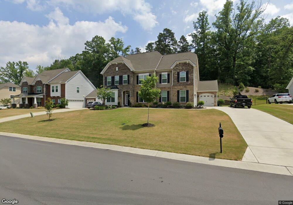
10600 Alabaster Dr Davidson, NC 28036
Estimated Value: $730,850 - $757,000
5
Beds
6
Baths
4,114
Sq Ft
$181/Sq Ft
Est. Value
About This Home
This home is located at 10600 Alabaster Dr, Davidson, NC 28036 and is currently estimated at $745,713, approximately $181 per square foot. 10600 Alabaster Dr is a home located in Cabarrus County with nearby schools including W.R. Odell Elementary School, Harris Road Middle, and Northwest Cabarrus High.
Ownership History
Date
Name
Owned For
Owner Type
Purchase Details
Closed on
Nov 26, 2013
Sold by
Lennar Carolinas Llc
Bought by
Long Ii Harold R and Long Ann L T
Current Estimated Value
Home Financials for this Owner
Home Financials are based on the most recent Mortgage that was taken out on this home.
Original Mortgage
$215,797
Outstanding Balance
$161,611
Interest Rate
4.26%
Mortgage Type
New Conventional
Estimated Equity
$584,102
Purchase Details
Closed on
Feb 6, 2012
Sold by
Niblock Development Corp
Bought by
Crm Mid Atlantic Properties Llc
Create a Home Valuation Report for This Property
The Home Valuation Report is an in-depth analysis detailing your home's value as well as a comparison with similar homes in the area
Home Values in the Area
Average Home Value in this Area
Purchase History
| Date | Buyer | Sale Price | Title Company |
|---|---|---|---|
| Long Ii Harold R | $333,000 | None Available | |
| Crm Mid Atlantic Properties Llc | $2,201,500 | None Available |
Source: Public Records
Mortgage History
| Date | Status | Borrower | Loan Amount |
|---|---|---|---|
| Open | Long Ii Harold R | $215,797 |
Source: Public Records
Tax History
| Year | Tax Paid | Tax Assessment Tax Assessment Total Assessment is a certain percentage of the fair market value that is determined by local assessors to be the total taxable value of land and additions on the property. | Land | Improvement |
|---|---|---|---|---|
| 2025 | $7,217 | $635,550 | $114,000 | $521,550 |
| 2024 | $7,217 | $635,550 | $114,000 | $521,550 |
| 2023 | $5,705 | $416,440 | $75,000 | $341,440 |
| 2022 | $5,705 | $416,440 | $75,000 | $341,440 |
| 2021 | $5,705 | $416,440 | $75,000 | $341,440 |
| 2020 | $5,705 | $416,440 | $75,000 | $341,440 |
| 2019 | $4,931 | $359,900 | $44,000 | $315,900 |
| 2018 | $4,859 | $359,900 | $44,000 | $315,900 |
| 2017 | $4,787 | $359,900 | $44,000 | $315,900 |
| 2016 | $4,787 | $348,830 | $55,000 | $293,830 |
| 2015 | $693 | $348,830 | $55,000 | $293,830 |
| 2014 | $693 | $348,830 | $55,000 | $293,830 |
Source: Public Records
Map
Nearby Homes
- 10997 Alabaster Dr
- 2870 Shale Dr
- 2921 Vista End Trail
- 10008 Manor Vista Trail
- 3344 Shiloh Church Rd
- 10004 Manor Vista Trail
- 10000 Manor Vista Trail
- 9996 Manor Vista Trail
- 9992 Manor Vista Trail
- 9988 Manor Vista Trail
- 1982 Smokey Quartz Rd
- 2600 Shiloh Church Rd
- 3455 Shiloh Church Rd
- 2580 Shiloh Church Rd
- 9965 Manor Vista Trail
- 9890 Travertine Trail
- 3316 Streamside Dr
- 3351 Streamside Dr
- 9905 Emerson Glen Dr
- 3388 Brackhill St
- 10550 Alabaster Dr Unit 38
- 10550 Alabaster Dr
- 10700 Alabaster Dr Unit 36
- 10700 Alabaster Dr
- 10500 Alabaster Dr
- 10800 Alabaster Dr Unit 35
- 3001 Placid Dr
- 10450 Alabaster Dr
- 10900 Alabaster Dr Unit 34
- 10900 Alabaster Dr
- 10400 Alabaster Dr
- 3050 Placid Dr
- 10970 Alabaster Dr
- 10350 Alabaster Dr Unit 42
- 10350 Alabaster Dr
- 10973 Sunstone Dr Unit 33
- 10300 Alabaster Dr
- 10300 Alabaster Dr Unit Lot 43
- 000 Placid Rd
- 10980 Alabaster Dr Unit 21
Your Personal Tour Guide
Ask me questions while you tour the home.