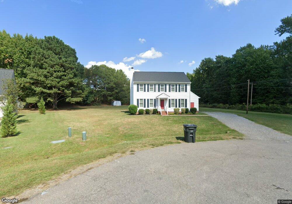
10600 Ramshorn Rd Midlothian, VA 23113
Robious NeighborhoodEstimated Value: $409,000 - $577,000
3
Beds
3
Baths
1,746
Sq Ft
$266/Sq Ft
Est. Value
About This Home
This home is located at 10600 Ramshorn Rd, Midlothian, VA 23113 and is currently estimated at $463,840, approximately $265 per square foot. 10600 Ramshorn Rd is a home located in Chesterfield County with nearby schools including Robious Elementary School, Robious Middle School, and James River High School.
Ownership History
Date
Name
Owned For
Owner Type
Purchase Details
Closed on
Jan 30, 2002
Bought by
Hardy Brenda C and Hardy Ronald D
Current Estimated Value
Home Financials for this Owner
Home Financials are based on the most recent Mortgage that was taken out on this home.
Original Mortgage
$108,000
Outstanding Balance
$44,941
Interest Rate
7.15%
Mortgage Type
New Conventional
Estimated Equity
$418,899
Create a Home Valuation Report for This Property
The Home Valuation Report is an in-depth analysis detailing your home's value as well as a comparison with similar homes in the area
Home Values in the Area
Average Home Value in this Area
Purchase History
| Date | Buyer | Sale Price | Title Company |
|---|---|---|---|
| Hardy Brenda C | -- | -- |
Source: Public Records
Mortgage History
| Date | Status | Borrower | Loan Amount |
|---|---|---|---|
| Open | Hardy Brenda C | $108,000 |
Source: Public Records
Tax History
| Year | Tax Paid | Tax Assessment Tax Assessment Total Assessment is a certain percentage of the fair market value that is determined by local assessors to be the total taxable value of land and additions on the property. | Land | Improvement |
|---|---|---|---|---|
| 2025 | $2,961 | $329,900 | $99,800 | $230,100 |
| 2024 | $2,961 | $321,500 | $95,000 | $226,500 |
| 2023 | $2,752 | $302,400 | $79,800 | $222,600 |
| 2022 | $2,535 | $275,500 | $70,300 | $205,200 |
| 2021 | $2,408 | $250,800 | $60,800 | $190,000 |
| 2020 | $2,239 | $235,700 | $60,800 | $174,900 |
| 2019 | $2,239 | $235,700 | $60,800 | $174,900 |
| 2018 | $2,174 | $228,800 | $58,900 | $169,900 |
| 2017 | $2,150 | $224,000 | $60,000 | $164,000 |
| 2016 | $1,974 | $205,600 | $58,000 | $147,600 |
| 2015 | $1,937 | $201,800 | $58,000 | $143,800 |
| 2014 | $1,851 | $192,800 | $58,000 | $134,800 |
Source: Public Records
Map
Nearby Homes
- 2721 Penrose Dr
- 3430 Old Gun Rd E
- 2139 Esquire Rd
- 2550 Cromwell Rd
- 9901 Channing Cir
- 2224 Dragonfly Ln
- 11013 Rockledge Rd
- 3121 Westgate Dr
- 10423 Crumpets Ln
- 10656 Honey Tree Rd
- 1706 Winding Way
- 9479 Creek Summit Cir
- 2217 Magnolia Grove Way
- 9477 Creek Summit Cir
- 2205 Magnolia Grove Way
- 9503 Groundhog Dr
- 11831 Aberdeen Landing Terrace
- 9490 Creek Summit Cir
- 2409 Brookwood Rd
- 9498 Creek Summit Cir
- 10610 Ramshorn Rd
- 10610 W Huguenot Rd
- 10610 Ramshorn Rd
- 10601 Ramshorn Rd
- 10610 W Huguenot Rd
- 2800 Old Gun Rd
- 10609 Ramshorn Rd
- 10617 Ramshorn Rd
- 10624 Ramshorn Rd
- 3009 E Martins Grant Cir
- 3007 E Martins Grant Cir
- 10600 Copperfield Place
- 10625 Ramshorn Rd
- 10602 Copperfield Place
- 3005 E Martins Grant Cir
- 10617 W Huguenot Rd
- 3003 E Martins Grant Cir
- 10634 Ramshorn Rd
- 10625 W Huguenot Rd
- 10607 W Huguenot Rd
Your Personal Tour Guide
Ask me questions while you tour the home.