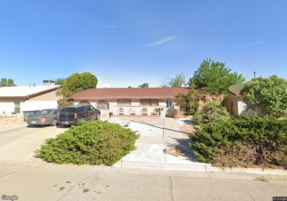
10605 Drillstone Dr El Paso, TX 79925
Eastwood NeighborhoodEstimated Value: $224,000 - $240,572
3
Beds
2
Baths
1,700
Sq Ft
$137/Sq Ft
Est. Value
About This Home
This home is located at 10605 Drillstone Dr, El Paso, TX 79925 and is currently estimated at $232,143, approximately $136 per square foot. 10605 Drillstone Dr is a home located in El Paso County with nearby schools including Edgemere International School, Eastwood Middle School, and Eastwood High School.
Ownership History
Date
Name
Owned For
Owner Type
Purchase Details
Closed on
Dec 21, 2004
Sold by
Nieto Jesus Eduardo and Nieto Luz Elena
Bought by
Leroy Amber N
Current Estimated Value
Home Financials for this Owner
Home Financials are based on the most recent Mortgage that was taken out on this home.
Original Mortgage
$98,800
Outstanding Balance
$49,644
Interest Rate
5.78%
Mortgage Type
Purchase Money Mortgage
Estimated Equity
$182,499
Create a Home Valuation Report for This Property
The Home Valuation Report is an in-depth analysis detailing your home's value as well as a comparison with similar homes in the area
Home Values in the Area
Average Home Value in this Area
Purchase History
| Date | Buyer | Sale Price | Title Company |
|---|---|---|---|
| Leroy Amber N | -- | -- |
Source: Public Records
Mortgage History
| Date | Status | Borrower | Loan Amount |
|---|---|---|---|
| Open | Leroy Amber N | $98,800 |
Source: Public Records
Tax History Compared to Growth
Tax History
| Year | Tax Paid | Tax Assessment Tax Assessment Total Assessment is a certain percentage of the fair market value that is determined by local assessors to be the total taxable value of land and additions on the property. | Land | Improvement |
|---|---|---|---|---|
| 2025 | $2,976 | $189,410 | -- | -- |
| 2024 | $2,976 | $172,191 | -- | -- |
| 2023 | $2,751 | $156,537 | $0 | $0 |
| 2022 | $4,419 | $142,306 | $0 | $0 |
| 2021 | $4,205 | $134,528 | $22,706 | $111,822 |
| 2020 | $3,715 | $117,608 | $20,261 | $97,347 |
| 2018 | $3,629 | $116,701 | $20,261 | $96,440 |
| 2017 | $3,302 | $108,032 | $20,261 | $87,771 |
| 2016 | $3,302 | $108,032 | $20,261 | $87,771 |
| 2015 | $2,667 | $113,076 | $20,261 | $92,815 |
| 2014 | $2,667 | $113,124 | $20,261 | $92,863 |
Source: Public Records
Map
Nearby Homes
- 10602 Drillstone Dr
- 3425 Brookrock St
- 3400 Brookrock St
- 10405 Darin Rd
- 10605 Kinross Ave Unit B
- 3213 Isla Cocoa Ln
- 3369 Freeport Dr
- 3332 Dungarvan Dr
- 3317 Dungarvan Dr
- 3453 Guthrie St
- 10216 Cardigan Dr
- 3345 Wexford Dr
- 10649 Islerock Dr
- 3318 Limerick Rd
- 10816 Cardigan Dr
- 3320 Tyrone Rd
- 3150 N Yarbrough Dr Unit A1
- 3300 Tyrone Rd
- 3112 Eads Place
- 3101 Vogue Dr
- 10609 Drillstone Dr
- 10601 Drillstone Dr
- 10520 Coralstone Dr
- 10600 Coralstone Dr
- 10541 Drillstone Dr
- 10613 Drillstone Dr
- 10604 Drillstone Dr
- 10604 Coralstone Dr
- 10608 Drillstone Dr
- 10535 Drillstone Dr
- 10516 Coralstone Dr
- 10612 Drillstone Dr
- 10617 Drillstone Dr
- 10608 Coralstone Dr
- 10531 Drillstone Dr
- 10600 Drillstone Dr
- 10616 Drillstone Dr
- 10544 Drillstone Dr
- 10512 Coralstone Dr
- 10601 Coralstone Dr