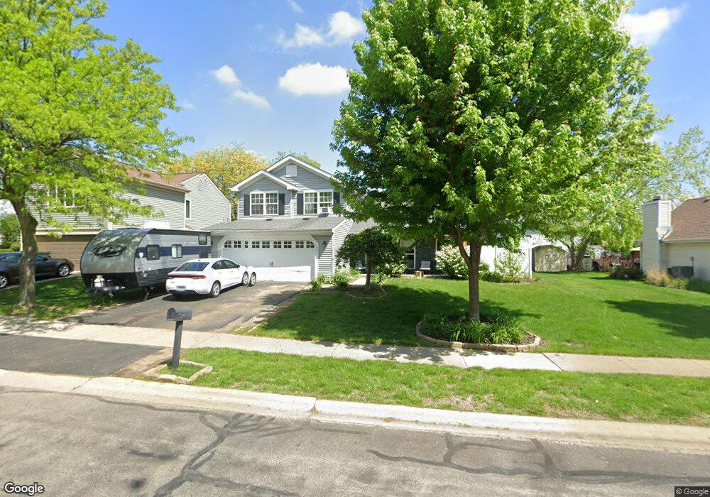
1061 Brookstone Dr Carol Stream, IL 60188
Estimated Value: $400,167 - $420,000
3
Beds
2
Baths
1,628
Sq Ft
$251/Sq Ft
Est. Value
About This Home
This home is located at 1061 Brookstone Dr, Carol Stream, IL 60188 and is currently estimated at $409,292, approximately $251 per square foot. 1061 Brookstone Dr is a home located in DuPage County with nearby schools including Field Kindergarten Center, Jordan Elementary School, and Heritage Lakes Elementary School.
Ownership History
Date
Name
Owned For
Owner Type
Purchase Details
Closed on
Apr 28, 2004
Sold by
Pfotenhauer Craig A and Pfotenhauer Christy L
Bought by
Latoria Joe and Latoria Kristi
Current Estimated Value
Home Financials for this Owner
Home Financials are based on the most recent Mortgage that was taken out on this home.
Original Mortgage
$197,600
Outstanding Balance
$92,646
Interest Rate
5.5%
Mortgage Type
Purchase Money Mortgage
Estimated Equity
$316,646
Purchase Details
Closed on
May 24, 2000
Sold by
Garrigus Craig G and Garrigus Deborah S
Bought by
Pfotenhauer Craig A and Pfotenhauer Christy L
Home Financials for this Owner
Home Financials are based on the most recent Mortgage that was taken out on this home.
Original Mortgage
$148,750
Interest Rate
8.13%
Create a Home Valuation Report for This Property
The Home Valuation Report is an in-depth analysis detailing your home's value as well as a comparison with similar homes in the area
Home Values in the Area
Average Home Value in this Area
Purchase History
| Date | Buyer | Sale Price | Title Company |
|---|---|---|---|
| Latoria Joe | $247,000 | Fox Title Company | |
| Pfotenhauer Craig A | $47,000 | -- |
Source: Public Records
Mortgage History
| Date | Status | Borrower | Loan Amount |
|---|---|---|---|
| Open | Latoria Joe | $197,600 | |
| Previous Owner | Pfotenhauer Craig A | $148,750 | |
| Closed | Latoria Joe | $49,400 |
Source: Public Records
Tax History Compared to Growth
Tax History
| Year | Tax Paid | Tax Assessment Tax Assessment Total Assessment is a certain percentage of the fair market value that is determined by local assessors to be the total taxable value of land and additions on the property. | Land | Improvement |
|---|---|---|---|---|
| 2024 | $8,732 | $109,812 | $35,469 | $74,343 |
| 2023 | $8,191 | $99,630 | $32,180 | $67,450 |
| 2022 | $7,990 | $92,600 | $29,910 | $62,690 |
| 2021 | $7,609 | $87,900 | $28,390 | $59,510 |
| 2020 | $7,443 | $85,270 | $27,540 | $57,730 |
| 2019 | $7,166 | $82,230 | $26,560 | $55,670 |
| 2018 | $6,740 | $78,690 | $25,420 | $53,270 |
| 2017 | $6,973 | $79,410 | $24,410 | $55,000 |
| 2016 | $6,841 | $75,860 | $23,320 | $52,540 |
| 2015 | $6,784 | $71,800 | $22,070 | $49,730 |
| 2014 | $6,709 | $69,980 | $21,510 | $48,470 |
| 2013 | $6,671 | $71,650 | $22,020 | $49,630 |
Source: Public Records
Map
Nearby Homes
- 848 Birchbark Trail
- 716 Shining Water Dr
- 716 Sand Creek Dr
- 911 Hampton Dr
- 1065 Brighton Dr
- 808 Trinity Ct
- 1304 Yorkshire Ln
- 1297 Woodlake Dr Unit 1
- 1080 Ridgefield Cir
- 1329 Gloucester Cir
- 654 Tacoma Dr
- 1340 Nantucket Ct
- 1333 Petersburg Ct
- 526 Alton Ct
- 641 Kingsbridge Dr
- 607 Kingsbridge Dr
- 515 Dakota Ct
- 1410 Georgetown Dr
- 1318 Antigo Trail
- 27W270 Jefferson St
- 1053 Brookstone Dr
- 1065 Brookstone Dr
- 1054 Mountain Glen Way
- 1048 Mountain Glen Way
- 1045 Brookstone Dr
- 1060 Mountain Glen Way
- 1060 Brookstone Dr
- 1056 Brookstone Dr
- 1042 Mountain Glen Way
- 1064 Brookstone Dr
- 1068 Mountain Glen Way
- 1079 Brookstone Dr
- 1072 Brookstone Dr
- 1044 Brookstone Dr
- 1074 Mountain Glen Way
- 1085 Brookstone Dr
- 954 Hill Crest Dr
- 1055 Cliff View Ln
- 1055 Mountain Glen Way