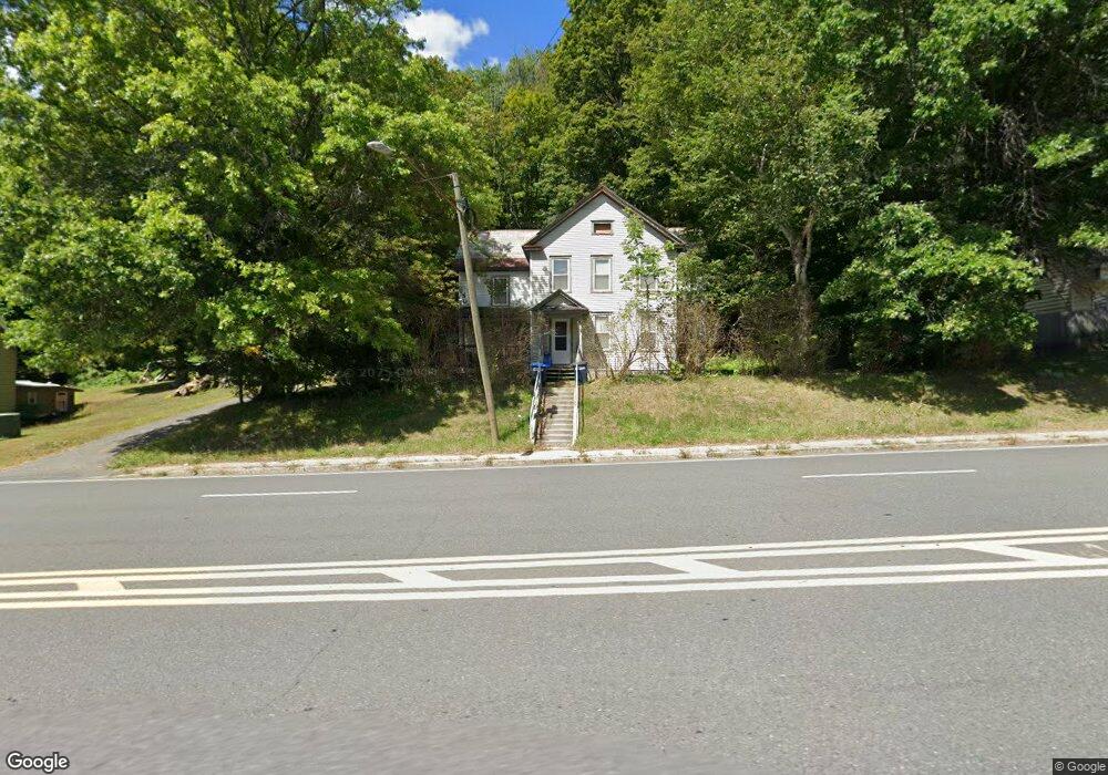
1061 Dalton Ave Pittsfield, MA 01201
Estimated Value: $225,000 - $352,000
5
Beds
2
Baths
1,862
Sq Ft
$149/Sq Ft
Est. Value
About This Home
This home is located at 1061 Dalton Ave, Pittsfield, MA 01201 and is currently estimated at $276,922, approximately $148 per square foot. 1061 Dalton Ave is a home located in Berkshire County with nearby schools including Allendale Elementary School, John T. Reid Middle School, and St. Agnes Academy.
Ownership History
Date
Name
Owned For
Owner Type
Purchase Details
Closed on
Aug 6, 1991
Sold by
Robert Rlty Co Inc
Bought by
City Sb Of Pittsfield
Current Estimated Value
Purchase Details
Closed on
Sep 15, 1989
Sold by
Krell Edwin G
Bought by
Lee Ronald W
Home Financials for this Owner
Home Financials are based on the most recent Mortgage that was taken out on this home.
Original Mortgage
$96,050
Interest Rate
9.58%
Mortgage Type
Purchase Money Mortgage
Purchase Details
Closed on
Jan 20, 1989
Sold by
City Sb Of Pitt
Bought by
Krell Edwin G
Home Financials for this Owner
Home Financials are based on the most recent Mortgage that was taken out on this home.
Original Mortgage
$70,000
Interest Rate
10.38%
Mortgage Type
Purchase Money Mortgage
Create a Home Valuation Report for This Property
The Home Valuation Report is an in-depth analysis detailing your home's value as well as a comparison with similar homes in the area
Home Values in the Area
Average Home Value in this Area
Purchase History
| Date | Buyer | Sale Price | Title Company |
|---|---|---|---|
| City Sb Of Pittsfield | $27,000 | -- | |
| City Sb Of Pittsfield | $27,000 | -- | |
| Lee Ronald W | $85,000 | -- | |
| Krell Edwin G | $70,000 | -- |
Source: Public Records
Mortgage History
| Date | Status | Borrower | Loan Amount |
|---|---|---|---|
| Previous Owner | Krell Edwin G | $96,050 | |
| Previous Owner | Krell Edwin G | $70,000 |
Source: Public Records
Tax History Compared to Growth
Tax History
| Year | Tax Paid | Tax Assessment Tax Assessment Total Assessment is a certain percentage of the fair market value that is determined by local assessors to be the total taxable value of land and additions on the property. | Land | Improvement |
|---|---|---|---|---|
| 2025 | $3,003 | $167,400 | $70,700 | $96,700 |
| 2024 | $2,823 | $153,000 | $70,700 | $82,300 |
| 2023 | $2,667 | $145,600 | $70,700 | $74,900 |
| 2022 | $2,520 | $135,800 | $70,700 | $65,100 |
| 2021 | $2,558 | $132,900 | $70,700 | $62,200 |
| 2020 | $2,379 | $120,700 | $60,700 | $60,000 |
| 2019 | $2,435 | $125,400 | $58,700 | $66,700 |
| 2018 | $2,459 | $122,900 | $58,700 | $64,200 |
| 2017 | $2,405 | $122,500 | $55,700 | $66,800 |
| 2016 | $2,319 | $123,600 | $55,700 | $67,900 |
| 2015 | $2,232 | $123,600 | $55,700 | $67,900 |
Source: Public Records
Map
Nearby Homes
- 144 Kittredge Rd
- 82 Williamsburg Terrace
- 90 Cheshire Rd
- 0 Crane Ave
- 17 Kittredge Rd
- 9 Crane Ave
- 63 Asci Dr
- 68 Howe Rd
- 386 Cheshire Rd
- 0 Cheshire Rd
- 134 Oak Hill Rd
- 127 Oak Hill Rd
- 66 Oak Street Extension
- 1 Pondview Dr Unit C3
- 18 Chestnut St
- 87 Maryland Ave
- 215 Partridge Rd
- 16 2nd St
- 1106 South St
- 122 Allengate Ave
- 1051 Dalton Ave
- 1073 Dalton Ave
- 1079 Dalton Ave
- 1099 Dalton Ave
- 1103 Dalton Ave
- 1109 Dalton Ave
- 1112 Dalton Ave
- 999 Dalton Ave
- 1125 Dalton Ave
- 64 Morningview Dr
- 58 Morningview Dr
- 72 Morningview Dr
- 1143 Dalton Ave
- 76 Morningview Dr
- 555 Hubbard Ave
- 50 Morningview Dr
- 969 Dalton Ave
- 42 Morningview Dr
- 53 Morningview Dr
- 100 Morningview Dr