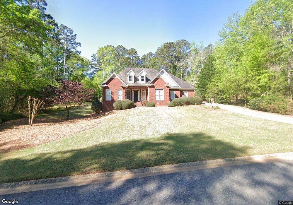
1061 Harrowford Rd N Statham, GA 30666
Estimated Value: $463,369 - $575,000
--
Bed
--
Bath
1,934
Sq Ft
$270/Sq Ft
Est. Value
About This Home
This home is located at 1061 Harrowford Rd N, Statham, GA 30666 and is currently estimated at $522,092, approximately $269 per square foot. 1061 Harrowford Rd N is a home located in Oconee County with nearby schools including Rocky Branch Elementary School, Malcom Bridge Middle School, and North Oconee High School.
Ownership History
Date
Name
Owned For
Owner Type
Purchase Details
Closed on
Dec 4, 2018
Sold by
Whitaker Michael T
Bought by
Tuley Terry E and Tuley Marcia A
Current Estimated Value
Purchase Details
Closed on
Mar 22, 2016
Sold by
Whitaker Heather
Bought by
Whitaker Michael T
Purchase Details
Closed on
May 15, 2013
Sold by
Whitaker Todd
Bought by
Whitaker Michael T
Home Financials for this Owner
Home Financials are based on the most recent Mortgage that was taken out on this home.
Original Mortgage
$142,500
Interest Rate
3.42%
Mortgage Type
New Conventional
Purchase Details
Closed on
Feb 10, 2003
Sold by
Giddens Giddens R and Giddens Allen
Bought by
Whitaker Todd
Purchase Details
Closed on
Apr 22, 2002
Sold by
H & H General Contractors Inc
Bought by
Giddens Giddens R and Giddens Allen
Purchase Details
Closed on
Feb 28, 2002
Sold by
Garrett Betty S
Bought by
H & H General Contractors Inc
Create a Home Valuation Report for This Property
The Home Valuation Report is an in-depth analysis detailing your home's value as well as a comparison with similar homes in the area
Home Values in the Area
Average Home Value in this Area
Purchase History
| Date | Buyer | Sale Price | Title Company |
|---|---|---|---|
| Tuley Terry E | $279,900 | -- | |
| Whitaker Michael T | -- | -- | |
| Whitaker Michael T | -- | -- | |
| Whitaker Todd | $202,900 | -- | |
| Giddens Giddens R | $35,500 | -- | |
| H & H General Contractors Inc | $210,000 | -- |
Source: Public Records
Mortgage History
| Date | Status | Borrower | Loan Amount |
|---|---|---|---|
| Previous Owner | Whitaker Michael T | $142,500 |
Source: Public Records
Tax History Compared to Growth
Tax History
| Year | Tax Paid | Tax Assessment Tax Assessment Total Assessment is a certain percentage of the fair market value that is determined by local assessors to be the total taxable value of land and additions on the property. | Land | Improvement |
|---|---|---|---|---|
| 2024 | $3,733 | $186,720 | $30,000 | $156,720 |
| 2023 | $3,672 | $169,657 | $22,000 | $147,657 |
| 2022 | $3,202 | $147,772 | $22,000 | $125,772 |
| 2021 | $3,125 | $133,618 | $22,000 | $111,618 |
| 2020 | $2,647 | $112,778 | $18,000 | $94,778 |
| 2019 | $2,596 | $110,580 | $18,000 | $92,580 |
| 2018 | $2,222 | $92,482 | $18,000 | $74,482 |
| 2017 | $2,065 | $85,855 | $18,000 | $67,855 |
Source: Public Records
Map
Nearby Homes
- LOT 10 Sikes Rd
- LOT 9 Sikes Rd
- LOT 8 Sikes Rd
- LOT 7 Sikes Rd
- LOT 6 Sikes Rd
- LOT 5 Sikes Rd
- LOT 4 Sikes Rd
- LOT 3 Sikes Rd
- LOT 2 Sikes Rd
- LOT 1 Sikes Rd
- 1080 Ashland Dr
- 1296 Club Estates Rd
- 1471 Sikes Rd
- N/A Hog Mountain Rd
- 1901 Hog Mountain Rd
- 1921 Hog Mountain Rd
- 2492 Rambling Rill Dr
- 4611 Monroe Hwy - Hwy 78
- 4611 Monroe Hwy - Hwy 78 Unit PARCEL C
- 2986 Coralbell Dr
- 1061 Harrowford Dr N
- 1041 Harrowford Dr N
- 1041 Harrowford Rd N
- 1071 Harrowford Rd N
- N Harrowford Dr N
- 1031 Harrowford Rd N
- 1031 Harrowford Dr N
- 1030 Harrowford Rd N
- 1030 Harrowford Dr N
- 1091 Harrowford Rd N
- 1091 Harrowford Dr N
- 1020 Harrowford Rd N
- 1011 Harrowford Dr N
- 1011 Harrowford Rd N
- 1071 Garrett Rd
- 1020 Richards Ct
- 1111 Harrowford Rd N
- 1010 Harrowford Dr N
- 1090 Harrowford Rd N
- 1010 Harrowford Rd N