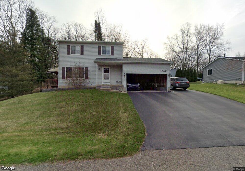
10617 Michael Blvd Pinckney, MI 48169
Estimated Value: $343,000 - $386,000
3
Beds
2
Baths
1,456
Sq Ft
$247/Sq Ft
Est. Value
About This Home
This home is located at 10617 Michael Blvd, Pinckney, MI 48169 and is currently estimated at $359,746, approximately $247 per square foot. 10617 Michael Blvd is a home located in Livingston County with nearby schools including Country Elementary School, Navigator School, and Pathfinder School.
Ownership History
Date
Name
Owned For
Owner Type
Purchase Details
Closed on
May 14, 2004
Sold by
Romano Vincent N and Romano Stacey L
Bought by
Symonds Mitchell and Symonds Jessica
Current Estimated Value
Home Financials for this Owner
Home Financials are based on the most recent Mortgage that was taken out on this home.
Original Mortgage
$194,567
Interest Rate
5.85%
Mortgage Type
Purchase Money Mortgage
Create a Home Valuation Report for This Property
The Home Valuation Report is an in-depth analysis detailing your home's value as well as a comparison with similar homes in the area
Home Values in the Area
Average Home Value in this Area
Purchase History
| Date | Buyer | Sale Price | Title Company |
|---|---|---|---|
| Symonds Mitchell | $188,900 | Capital Title Ins Agency |
Source: Public Records
Mortgage History
| Date | Status | Borrower | Loan Amount |
|---|---|---|---|
| Open | Symonds Mitchell | $158,650 | |
| Closed | Symonds Mitchell | $194,567 |
Source: Public Records
Tax History Compared to Growth
Tax History
| Year | Tax Paid | Tax Assessment Tax Assessment Total Assessment is a certain percentage of the fair market value that is determined by local assessors to be the total taxable value of land and additions on the property. | Land | Improvement |
|---|---|---|---|---|
| 2025 | $2,625 | $149,540 | $0 | $0 |
| 2024 | $879 | $144,470 | $0 | $0 |
| 2023 | $838 | $132,270 | $0 | $0 |
| 2022 | $1,628 | $106,240 | $0 | $0 |
| 2021 | $2,354 | $106,240 | $0 | $0 |
| 2020 | $2,321 | $106,310 | $0 | $0 |
| 2019 | $2,302 | $101,980 | $0 | $0 |
| 2018 | $2,273 | $88,350 | $0 | $0 |
| 2017 | $2,179 | $88,350 | $0 | $0 |
| 2016 | $2,108 | $85,070 | $0 | $0 |
| 2014 | $1,658 | $77,680 | $0 | $0 |
| 2012 | $1,658 | $67,270 | $0 | $0 |
Source: Public Records
Map
Nearby Homes
- 10499 Michael Blvd
- 10350 Half Moon Dr
- 2540 Lister Dr
- 9993 Tioga Trail Unit 154
- 9970 Whispering Woods Dr
- 3380 McCluskey
- 11410 Tall Shadows Ct
- 9771 Tioga Trail Unit 171
- 3558 Windwheel Point Dr
- 3590 Habitat Trail Unit 25
- 11527 Mcgregor Rd
- 11770 Woodview
- 00 Colony
- 11026 Colony Rd
- 11589 Lombardy Ct
- 11109 Wynns Rd
- 2939 Indian Trail
- 3450 Hooker Rd
- 9418 Charlie Brown Ln
- 4106 Shoreview Ln
- 2923 Harding St
- 10635 Michael Blvd
- 10593 Michael Blvd
- 2935 Harding St
- 1011 Michael Blvd
- 10634 Michael Blvd
- 10588 Michael Blvd
- 2932 Wilson Ave
- 2947 Harding St
- 10665 Michael Blvd
- 0 Michael Ave Unit 5355440
- 0 Michael Ave Unit 213088923
- 0 Michael Ave Unit 212024339
- 10570 Michael Blvd
- 2948 Wilson Ave
- 2924 Harding St
- 10666 Michael Blvd
- 2959 Harding St
- 0 Michael Blvd Unit 218011221
- 0 Michael Blvd Unit 5233780