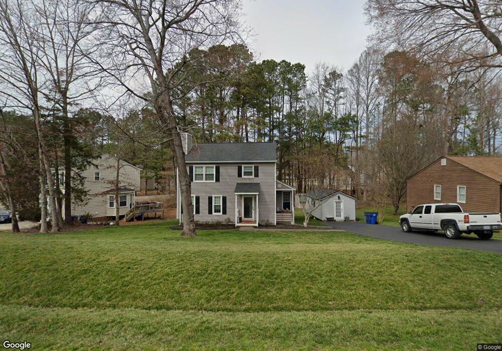
10618 Bexwood Ct Chesterfield, VA 23832
Estimated Value: $321,000 - $341,000
3
Beds
3
Baths
1,456
Sq Ft
$229/Sq Ft
Est. Value
About This Home
This home is located at 10618 Bexwood Ct, Chesterfield, VA 23832 and is currently estimated at $333,498, approximately $229 per square foot. 10618 Bexwood Ct is a home located in Chesterfield County with nearby schools including Thelma Crenshaw Elementary School, Bailey Bridge Middle School, and Manchester High.
Ownership History
Date
Name
Owned For
Owner Type
Purchase Details
Closed on
Jun 20, 2005
Sold by
Collyer Scott M
Bought by
Messick Patrick M
Current Estimated Value
Home Financials for this Owner
Home Financials are based on the most recent Mortgage that was taken out on this home.
Original Mortgage
$129,600
Outstanding Balance
$67,528
Interest Rate
5.73%
Mortgage Type
New Conventional
Estimated Equity
$265,970
Purchase Details
Closed on
Apr 1, 2002
Sold by
Bumbalo Brian J
Bought by
Collyer Scott M
Home Financials for this Owner
Home Financials are based on the most recent Mortgage that was taken out on this home.
Original Mortgage
$104,176
Interest Rate
6.88%
Mortgage Type
FHA
Create a Home Valuation Report for This Property
The Home Valuation Report is an in-depth analysis detailing your home's value as well as a comparison with similar homes in the area
Home Values in the Area
Average Home Value in this Area
Purchase History
| Date | Buyer | Sale Price | Title Company |
|---|---|---|---|
| Messick Patrick M | $162,000 | -- | |
| Collyer Scott M | $105,000 | -- |
Source: Public Records
Mortgage History
| Date | Status | Borrower | Loan Amount |
|---|---|---|---|
| Open | Messick Patrick M | $129,600 | |
| Previous Owner | Collyer Scott M | $104,176 |
Source: Public Records
Tax History Compared to Growth
Tax History
| Year | Tax Paid | Tax Assessment Tax Assessment Total Assessment is a certain percentage of the fair market value that is determined by local assessors to be the total taxable value of land and additions on the property. | Land | Improvement |
|---|---|---|---|---|
| 2025 | $2,495 | $277,500 | $60,000 | $217,500 |
| 2024 | $2,495 | $266,400 | $54,000 | $212,400 |
| 2023 | $2,322 | $255,200 | $51,000 | $204,200 |
| 2022 | $2,192 | $238,300 | $49,000 | $189,300 |
| 2021 | $2,076 | $211,600 | $47,000 | $164,600 |
| 2020 | $1,769 | $186,200 | $45,000 | $141,200 |
| 2019 | $1,734 | $182,500 | $44,000 | $138,500 |
| 2018 | $1,632 | $171,800 | $42,000 | $129,800 |
| 2017 | $1,557 | $162,200 | $42,000 | $120,200 |
| 2016 | $1,459 | $152,000 | $42,000 | $110,000 |
| 2015 | $1,498 | $153,400 | $42,000 | $111,400 |
| 2014 | $1,486 | $152,200 | $42,000 | $110,200 |
Source: Public Records
Map
Nearby Homes
- 4519 Bexwood Dr
- 10800 Brookridge Way
- 4533 Overlea Dr
- 10810 Ridgerun Rd
- 11118 Sunfield Dr
- 10524 Genlou Rd
- 5101 Blossomwood Cir
- 5124 Rollingway Rd
- 5213 Oakforest Dr
- 10508 Rollingway Ct
- 10927 Decoy Ln
- 10556 Braden Woods Ct
- 11261 Sunfield Dr
- 11130 Poachers Run
- 10718 Genlou Rd
- Stanley Plan at Lawson Mill
- Caldwell Plan at Lawson Mill
- Oxford Plan at Lawson Mill
- Cypress Plan at Lawson Mill
- Davidson Plan at Lawson Mill
- 10624 Bexwood Ct
- 10612 Bexwood Ct
- 4531 Bexwood Dr
- 10606 Bexwood Ct
- 10613 Bexwood Ct
- 10619 Bexwood Ct
- 10625 Bexwood Ct
- 10701 Snare Ct
- 4525 Bexwood Dr
- 10607 Bexwood Ct
- 4606 Bexwood Dr
- 10631 Bexwood Ct
- 10600 Bexwood Ct
- 4530 Bexwood Dr
- 4705 Bexwood Dr
- 4654 Brookridge Rd
- 4648 Brookridge Rd
- 4700 Bexwood Dr
- 10707 Snare Ct
- 4660 Brookridge Rd