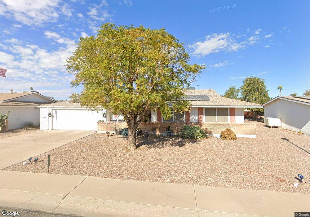
10618 W Caron Dr Sun City, AZ 85351
Estimated Value: $260,931 - $328,000
--
Bed
2
Baths
1,658
Sq Ft
$182/Sq Ft
Est. Value
About This Home
This home is located at 10618 W Caron Dr, Sun City, AZ 85351 and is currently estimated at $300,983, approximately $181 per square foot. 10618 W Caron Dr is a home located in Maricopa County with nearby schools including Ombudsman - Northwest Charter and Peoria Accelerated High School.
Ownership History
Date
Name
Owned For
Owner Type
Purchase Details
Closed on
Dec 15, 1999
Sold by
Phillips Stanley A and Stanley A & Cora C Phillips Re
Bought by
Schuster George E and Schuster Dorothy A
Current Estimated Value
Home Financials for this Owner
Home Financials are based on the most recent Mortgage that was taken out on this home.
Original Mortgage
$79,200
Outstanding Balance
$24,457
Interest Rate
7.68%
Mortgage Type
New Conventional
Estimated Equity
$276,526
Purchase Details
Closed on
Oct 3, 1997
Sold by
Phillips Stanley A and Phillips Cora C
Bought by
Phillips Stanley A and Phillips Cora C
Create a Home Valuation Report for This Property
The Home Valuation Report is an in-depth analysis detailing your home's value as well as a comparison with similar homes in the area
Home Values in the Area
Average Home Value in this Area
Purchase History
| Date | Buyer | Sale Price | Title Company |
|---|---|---|---|
| Schuster George E | $88,000 | -- | |
| Phillips Stanley A | -- | -- |
Source: Public Records
Mortgage History
| Date | Status | Borrower | Loan Amount |
|---|---|---|---|
| Open | Schuster George E | $79,200 |
Source: Public Records
Tax History Compared to Growth
Tax History
| Year | Tax Paid | Tax Assessment Tax Assessment Total Assessment is a certain percentage of the fair market value that is determined by local assessors to be the total taxable value of land and additions on the property. | Land | Improvement |
|---|---|---|---|---|
| 2025 | $1,068 | $13,204 | -- | -- |
| 2024 | $960 | $12,575 | -- | -- |
| 2023 | $960 | $22,920 | $4,580 | $18,340 |
| 2022 | $905 | $17,980 | $3,590 | $14,390 |
| 2021 | $934 | $16,810 | $3,360 | $13,450 |
| 2020 | $909 | $14,770 | $2,950 | $11,820 |
| 2019 | $892 | $13,780 | $2,750 | $11,030 |
| 2018 | $859 | $12,570 | $2,510 | $10,060 |
| 2017 | $830 | $11,230 | $2,240 | $8,990 |
| 2016 | $439 | $10,620 | $2,120 | $8,500 |
| 2015 | $739 | $9,520 | $1,900 | $7,620 |
Source: Public Records
Map
Nearby Homes
- 10707 W Mission Ln
- 9202 N 107th Ave Unit 8
- 10726 W Kelso Dr Unit 172
- 10731 W Mission Ln Unit 200
- 10726 W Denham Dr Unit 16
- 10732 W Denham Dr Unit 17
- 10825 W Caron Dr
- 8803 N 105th Dr
- 10326 W Caron Dr
- 8800 N 107th Ave Unit 17
- 8800 N 107th Ave Unit 19
- 8800 N 107th Ave Unit 52
- 10512 W Ruth Ave
- 10816 W Venturi Dr
- 10801 W Mountain View Rd
- 10603 W Ruth Ave
- 9802 N 107th Ave
- 9815 N 103rd Ave
- 10788 W Cinnebar Ave
- 10316 W Salem Dr Unit 6D
- 10624 W Caron Dr
- 10612 W Caron Dr
- 10627 W Kelso Dr
- 10617 W Kelso Dr
- 10633 W Kelso Dr Unit 7
- 10630 W Caron Dr
- 10602 W Caron Dr
- 10609 W Kelso Dr
- 10605 W Caron Dr
- 10635 W Kelso Dr
- 10629 W Caron Dr
- 10603 W Kelso Dr
- 10636 W Caron Dr
- 10548 W Caron Dr
- 10619 W Caron Dr
- 10541 W Caron Dr
- 10631 W Caron Dr Unit REMDL
- 10631 W Caron Dr
- 10628 W Kelso Dr
- 10639 W Kelso Dr