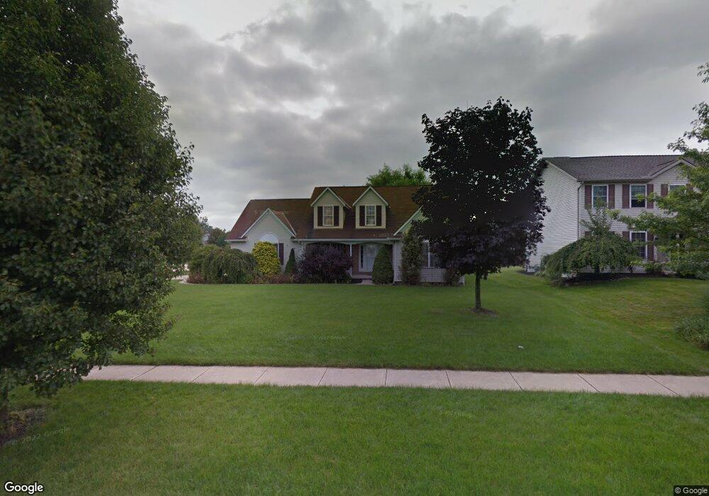
1063 Luray Ln Brunswick, OH 44212
Estimated Value: $359,000 - $393,000
3
Beds
2
Baths
1,945
Sq Ft
$191/Sq Ft
Est. Value
About This Home
This home is located at 1063 Luray Ln, Brunswick, OH 44212 and is currently estimated at $371,408, approximately $190 per square foot. 1063 Luray Ln is a home located in Medina County with nearby schools including C.R. Towslee Elementary School, Willets Middle School, and Brunswick High School.
Ownership History
Date
Name
Owned For
Owner Type
Purchase Details
Closed on
Jan 11, 2000
Sold by
Golden Falcon Construction Co
Bought by
Rolnicki Richard R and Rolnicki Judith C
Current Estimated Value
Home Financials for this Owner
Home Financials are based on the most recent Mortgage that was taken out on this home.
Original Mortgage
$159,600
Outstanding Balance
$50,900
Interest Rate
7.89%
Estimated Equity
$320,508
Purchase Details
Closed on
Oct 1, 1999
Sold by
Knight Development Corp
Bought by
Falcon Construction Co Inc
Create a Home Valuation Report for This Property
The Home Valuation Report is an in-depth analysis detailing your home's value as well as a comparison with similar homes in the area
Home Values in the Area
Average Home Value in this Area
Purchase History
| Date | Buyer | Sale Price | Title Company |
|---|---|---|---|
| Rolnicki Richard R | $199,600 | -- | |
| Falcon Construction Co Inc | $43,500 | -- |
Source: Public Records
Mortgage History
| Date | Status | Borrower | Loan Amount |
|---|---|---|---|
| Open | Rolnicki Richard R | $159,600 |
Source: Public Records
Tax History Compared to Growth
Tax History
| Year | Tax Paid | Tax Assessment Tax Assessment Total Assessment is a certain percentage of the fair market value that is determined by local assessors to be the total taxable value of land and additions on the property. | Land | Improvement |
|---|---|---|---|---|
| 2024 | $4,514 | $101,100 | $23,810 | $77,290 |
| 2023 | $4,514 | $101,100 | $23,810 | $77,290 |
| 2022 | $4,319 | $101,100 | $23,810 | $77,290 |
| 2021 | $3,729 | $80,240 | $18,900 | $61,340 |
| 2020 | $3,356 | $80,240 | $18,900 | $61,340 |
| 2019 | $3,357 | $80,240 | $18,900 | $61,340 |
| 2018 | $2,953 | $68,400 | $16,700 | $51,700 |
| 2017 | $2,957 | $68,400 | $16,700 | $51,700 |
| 2016 | $2,954 | $68,400 | $16,700 | $51,700 |
| 2015 | $2,735 | $62,180 | $15,180 | $47,000 |
| 2014 | $2,726 | $62,180 | $15,180 | $47,000 |
| 2013 | $2,666 | $62,180 | $15,180 | $47,000 |
Source: Public Records
Map
Nearby Homes
- 4203 Regal Ave
- 1200 Queens Ave Unit 31
- 1044-1070 Pearl Rd
- 3976 Buckingham Dr
- 4224 Maiden Ct
- 1291 Jester Ct Unit B253
- 3991 Buckingham Dr
- 4351 Oak Ridge Trail
- 4355 Oak Ridge Trail
- 4339 Oak Ridge Trail
- 4349 Inner Circle Dr Unit A-5
- 858 Quinebaug Ct
- 4259 Pelham Way
- 0 Center Rd Unit 4467135
- V/L Pearl Rd
- 4383 Inner Circle Dr Unit C24
- 4383 Inner Circle Dr Unit A24
- 4385 Inner Circle Dr Unit B-18
- 4383 Inner Circle Dr Unit B22
- 0 Pearl Rd Unit 4173749
- 1077 Luray Ln
- 1062 Middlefield Trail
- 1079 Luray Ln
- 1070 Middlefield Trail
- 4144 Roanoke Dr
- 4127 Roanoke Dr
- 4119 Roanoke Dr
- 4135 Roanoke Dr
- 1078 Middlefield Trail
- 4111 Roanoke Dr
- 1087 Luray Ln
- 4139 Willow Grove Ln
- 4143 Roanoke Dr
- 4152 Roanoke Dr
- 4103 Roanoke Dr
- 1086 Middlefield Trail
- 1093 Luray Ln
- 4145 Willow Grove Ln
- 4151 Roanoke Dr
- 4097 Roanoke Dr