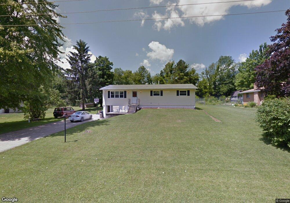
1063 Ramsey Dr Mansfield, OH 44905
Estimated Value: $149,000 - $188,000
4
Beds
2
Baths
1,144
Sq Ft
$145/Sq Ft
Est. Value
About This Home
This home is located at 1063 Ramsey Dr, Mansfield, OH 44905 and is currently estimated at $166,027, approximately $145 per square foot. 1063 Ramsey Dr is a home located in Richland County with nearby schools including Madison High School, St. Mary Catholic School, and Temple-Christian School.
Ownership History
Date
Name
Owned For
Owner Type
Purchase Details
Closed on
Apr 12, 2021
Sold by
Tenney Donald R
Bought by
Tenney Shannon
Current Estimated Value
Purchase Details
Closed on
Dec 28, 2009
Sold by
Tenney Donald R and Tenney Sharon Lee
Bought by
Tenney Donald R and Tenney Sharon Lee
Purchase Details
Closed on
Dec 21, 2009
Sold by
The Secretary Of Veterans Affairs
Bought by
Tenney Donald R
Purchase Details
Closed on
Jul 7, 2009
Sold by
Roose Lannie B
Bought by
Secretary Of Veterans Affairs
Purchase Details
Closed on
Jun 2, 2006
Sold by
Shultz Ellen L and Shultz Ellen Loretta
Bought by
Roose Lannie B
Home Financials for this Owner
Home Financials are based on the most recent Mortgage that was taken out on this home.
Original Mortgage
$93,875
Interest Rate
6.62%
Mortgage Type
VA
Purchase Details
Closed on
May 12, 2003
Sold by
Estate Of Robert Eugene Shultz
Bought by
Shultz Ellen Loretta
Create a Home Valuation Report for This Property
The Home Valuation Report is an in-depth analysis detailing your home's value as well as a comparison with similar homes in the area
Home Values in the Area
Average Home Value in this Area
Purchase History
| Date | Buyer | Sale Price | Title Company |
|---|---|---|---|
| Tenney Shannon | $50,000 | None Available | |
| Tenney Donald R | -- | Barrister Lawyers Title | |
| Tenney Donald R | -- | Barrister Lawyers Title | |
| Secretary Of Veterans Affairs | $48,000 | None Available | |
| Roose Lannie B | $91,900 | Chicago Title | |
| Shultz Ellen Loretta | -- | -- |
Source: Public Records
Mortgage History
| Date | Status | Borrower | Loan Amount |
|---|---|---|---|
| Previous Owner | Roose Lannie B | $93,875 |
Source: Public Records
Tax History Compared to Growth
Tax History
| Year | Tax Paid | Tax Assessment Tax Assessment Total Assessment is a certain percentage of the fair market value that is determined by local assessors to be the total taxable value of land and additions on the property. | Land | Improvement |
|---|---|---|---|---|
| 2024 | $1,733 | $33,710 | $4,890 | $28,820 |
| 2023 | $1,733 | $33,710 | $4,890 | $28,820 |
| 2022 | $1,544 | $27,610 | $4,640 | $22,970 |
| 2021 | $1,582 | $27,610 | $4,640 | $22,970 |
| 2020 | $1,594 | $27,610 | $4,640 | $22,970 |
| 2019 | $1,452 | $23,420 | $3,940 | $19,480 |
| 2018 | $1,441 | $23,420 | $3,940 | $19,480 |
| 2017 | $1,415 | $23,420 | $3,940 | $19,480 |
| 2016 | $1,464 | $23,680 | $3,820 | $19,860 |
| 2015 | $1,464 | $23,680 | $3,820 | $19,860 |
| 2014 | $1,435 | $23,680 | $3,820 | $19,860 |
| 2012 | $679 | $24,410 | $3,940 | $20,470 |
Source: Public Records
Map
Nearby Homes
- 1910 Crider Rd
- 903 Mayflower Ave
- 1806 Richard Dr
- 1997 Hout Rd
- 1106 Keller Dr Unit 1108
- 1951 Woodmont Rd
- 640 Running Brook Way
- 683 Coachman Rd
- 671 Coachman Rd
- 2270 Lakecrest Dr Unit 2272
- 632 Coachman Rd
- 1151 Beal Rd
- 1226 Evergreen Ave W
- 1282 Redman Ave
- 602 Champion Rd
- 644 Skyline Rd
- 1199 Evergreen Ave W
- 1183 Evergreen Ave W
- 1150 Delwood Dr
- 1158 Delwood Rd