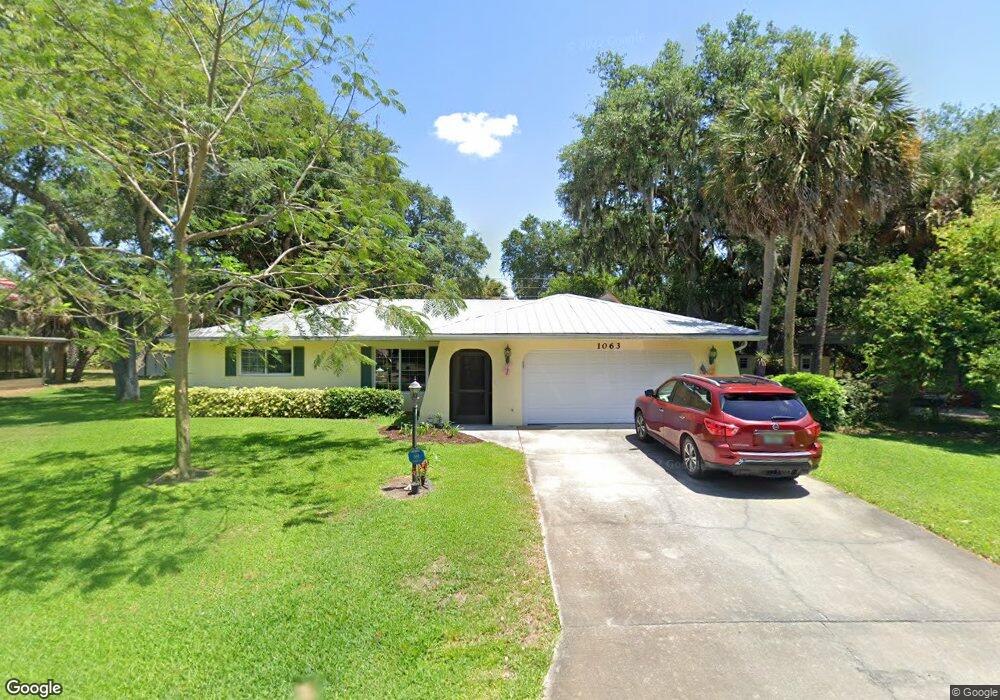
1063 Seacrest Dr NW Port Charlotte, FL 33948
Estimated Value: $265,851 - $318,000
3
Beds
2
Baths
1,467
Sq Ft
$192/Sq Ft
Est. Value
About This Home
This home is located at 1063 Seacrest Dr NW, Port Charlotte, FL 33948 and is currently estimated at $282,213, approximately $192 per square foot. 1063 Seacrest Dr NW is a home located in Charlotte County with nearby schools including Meadow Park Elementary School, Murdock Middle School, and Port Charlotte High School.
Ownership History
Date
Name
Owned For
Owner Type
Purchase Details
Closed on
Aug 27, 2015
Sold by
Burris Gerald W and Burris Pauline E
Bought by
Burris Gerald W and Burris Pauline E
Current Estimated Value
Purchase Details
Closed on
Aug 11, 1995
Sold by
Vacca Susan and Newman Lorenda E
Bought by
Hunter John and Hunter Rose A
Home Financials for this Owner
Home Financials are based on the most recent Mortgage that was taken out on this home.
Original Mortgage
$52,000
Interest Rate
7.48%
Create a Home Valuation Report for This Property
The Home Valuation Report is an in-depth analysis detailing your home's value as well as a comparison with similar homes in the area
Home Values in the Area
Average Home Value in this Area
Purchase History
| Date | Buyer | Sale Price | Title Company |
|---|---|---|---|
| Burris Gerald W | -- | Attorney | |
| Hunter John | -- | -- |
Source: Public Records
Mortgage History
| Date | Status | Borrower | Loan Amount |
|---|---|---|---|
| Closed | Hunter John | $52,000 |
Source: Public Records
Tax History Compared to Growth
Tax History
| Year | Tax Paid | Tax Assessment Tax Assessment Total Assessment is a certain percentage of the fair market value that is determined by local assessors to be the total taxable value of land and additions on the property. | Land | Improvement |
|---|---|---|---|---|
| 2025 | $688 | $87,350 | -- | -- |
| 2024 | $1,437 | $84,888 | -- | -- |
| 2023 | $1,437 | $82,416 | $0 | $0 |
| 2022 | $1,363 | $80,016 | $0 | $0 |
| 2021 | $1,340 | $77,685 | $0 | $0 |
| 2020 | $617 | $76,612 | $0 | $0 |
| 2019 | $1,216 | $74,890 | $0 | $0 |
| 2018 | $1,118 | $73,494 | $0 | $0 |
| 2017 | $1,114 | $71,982 | $0 | $0 |
| 2016 | $1,113 | $70,501 | $0 | $0 |
| 2015 | $570 | $70,011 | $0 | $0 |
| 2014 | $571 | $69,455 | $0 | $0 |
Source: Public Records
Map
Nearby Homes
- 2120 Broad Ranch Dr
- 1073 Arden Terrace NW
- 1042 Malay Terrace NW
- 1035 Red Bay Terrace NW
- 1030 Malay Terrace NW
- 1024 Malay Terrace NW
- 928 Tropical Ave NW
- 1190 Seacrest Dr NW
- 917 Tropical Ave NW
- 948 Tropical Ave NW
- 1001 Malay Terrace NW
- 1181 Seacrest Dr NW
- 953 Tropical Ave NW
- 1063 Reed Terrace NW
- 1087 Reed Terrace NW
- 2220 Broad Ranch Dr
- 787 Crestview Cir NW
- 949 Chevy Chase St NW
- 957 Chevy Chase St NW
- 913 Great Falls Terrace NW
- 1069 Seacrest Dr NW
- 1059 Seacrest Dr NW
- 1060 Seacrest Dr NW
- 1053 Seacrest Dr NW
- 1071 Seacrest Dr NW
- 1072 Seacrest Dr NW
- 1075 Seacrest Dr NW
- 2090 Broad Ranch Dr
- 1067 Arden Terrace NW
- 2101 Broad Ranch Dr
- 1079 Arden Terrace NW
- 2111 Broad Ranch Dr
- 2091 Broad Ranch Dr
- 1084 Seacrest Dr NW
- 1061 Arden Terrace NW
- 2082 Broad Ranch Dr
- 1083 Seacrest Dr NW
- 2121 Broad Ranch Dr
- 1019 Red Bay Terrace NW
- 1054 Malay Terrace NW