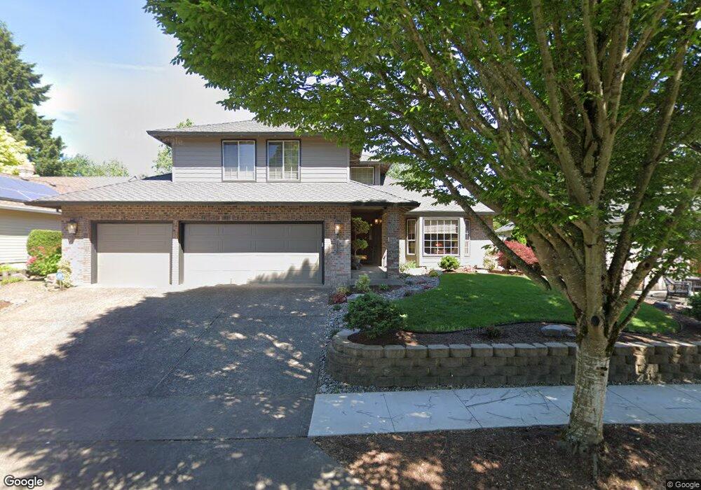
10630 SW 133rd Place Beaverton, OR 97008
South Beaverton NeighborhoodEstimated Value: $709,628 - $795,000
4
Beds
3
Baths
2,561
Sq Ft
$298/Sq Ft
Est. Value
About This Home
This home is located at 10630 SW 133rd Place, Beaverton, OR 97008 and is currently estimated at $762,157, approximately $297 per square foot. 10630 SW 133rd Place is a home located in Washington County with nearby schools including Hiteon Elementary School, Conestoga Middle School, and Southridge High School.
Ownership History
Date
Name
Owned For
Owner Type
Purchase Details
Closed on
Feb 2, 2023
Sold by
Hampton Lola M and Hampton Forrest K
Bought by
Lola M Hampton Revocable Living Trust and Hampton
Current Estimated Value
Create a Home Valuation Report for This Property
The Home Valuation Report is an in-depth analysis detailing your home's value as well as a comparison with similar homes in the area
Home Values in the Area
Average Home Value in this Area
Purchase History
| Date | Buyer | Sale Price | Title Company |
|---|---|---|---|
| Lola M Hampton Revocable Living Trust | -- | None Listed On Document |
Source: Public Records
Tax History Compared to Growth
Tax History
| Year | Tax Paid | Tax Assessment Tax Assessment Total Assessment is a certain percentage of the fair market value that is determined by local assessors to be the total taxable value of land and additions on the property. | Land | Improvement |
|---|---|---|---|---|
| 2026 | $8,746 | $426,940 | -- | -- |
| 2025 | $8,746 | $414,510 | -- | -- |
| 2024 | $8,257 | $402,440 | -- | -- |
| 2023 | $8,257 | $390,720 | $0 | $0 |
| 2022 | $7,903 | $390,720 | $0 | $0 |
| 2021 | $7,626 | $368,300 | $0 | $0 |
| 2020 | $7,394 | $357,580 | $0 | $0 |
| 2019 | $7,160 | $347,170 | $0 | $0 |
| 2018 | $6,932 | $337,060 | $0 | $0 |
| 2017 | $6,673 | $327,250 | $0 | $0 |
| 2016 | $6,441 | $317,720 | $0 | $0 |
| 2015 | $6,201 | $308,470 | $0 | $0 |
| 2014 | $6,069 | $299,490 | $0 | $0 |
Source: Public Records
Map
Nearby Homes
- 10835 SW Huntington Ave
- 10820 SW Huntington Ave
- 10830 SW Briarwood Place
- 10910 SW Huntington Ave
- 13180 SW Haystack Dr
- 10923 SW Sage Terrace
- 10845 SW Summer Lake Dr
- 13775 SW Scholls Ferry Rd Unit 205
- 13775 SW Scholls Ferry Rd Unit 3
- 13775 SW Scholls Ferry Rd Unit 212
- 13250 SW Weir Rd
- 0 SW Scholls Ferry Rd
- 11325 SW Eucalyptus Place
- 9965 SW Pimlico Terrace
- 13850 SW Scholls Ferry Rd Unit 102
- 13495 SW Brittany Dr
- 11494 SW Lakeview Terrace
- 9625 SW 130th Ave
- 13675 SW Feiring Ln
- 11769 SW 129th Place
- 10610 SW 133rd Place
- 10650 SW 133rd Place
- 10625 SW Cottontail Place
- 10635 SW Cottontail Place
- 10615 SW Cottontail Place
- 10635 SW 133rd Place
- 10670 SW 133rd Place
- 13290 SW Cottontail Ln
- 10615 SW 133rd Place
- 10645 SW Cottontail Place
- 10575 SW Cottontail Place
- 13270 SW Cottontail Ln
- 10655 SW 133rd Place
- 10690 SW 133rd Place
- 10555 SW Cottontail Place
- 13350 SW Cottontail Ln
- 10655 SW Cottontail Place
- 10600 SW Cottontail Place
- 10675 SW 133rd Place
- 10695 SW 133rd Place