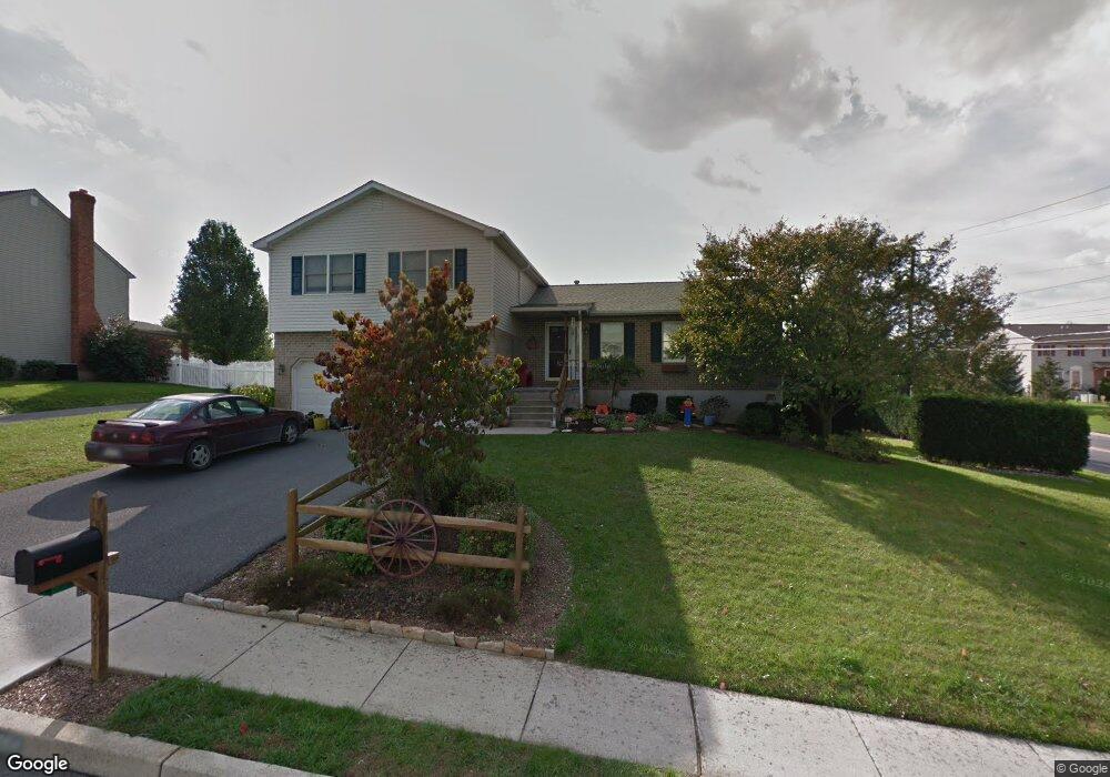
1064 Boeshore Cir Reading, PA 19605
Riverview Park NeighborhoodEstimated Value: $328,386 - $391,000
3
Beds
3
Baths
1,584
Sq Ft
$221/Sq Ft
Est. Value
About This Home
This home is located at 1064 Boeshore Cir, Reading, PA 19605 and is currently estimated at $349,597, approximately $220 per square foot. 1064 Boeshore Cir is a home located in Berks County with nearby schools including C E Cole Intermediate School, Muhlenberg Elementary Center, and Muhlenberg Junior High School.
Ownership History
Date
Name
Owned For
Owner Type
Purchase Details
Closed on
Aug 8, 1995
Bought by
Messner John C and Messner Maureen K
Current Estimated Value
Create a Home Valuation Report for This Property
The Home Valuation Report is an in-depth analysis detailing your home's value as well as a comparison with similar homes in the area
Home Values in the Area
Average Home Value in this Area
Purchase History
| Date | Buyer | Sale Price | Title Company |
|---|---|---|---|
| Messner John C | $127,000 | -- |
Source: Public Records
Tax History Compared to Growth
Tax History
| Year | Tax Paid | Tax Assessment Tax Assessment Total Assessment is a certain percentage of the fair market value that is determined by local assessors to be the total taxable value of land and additions on the property. | Land | Improvement |
|---|---|---|---|---|
| 2025 | $1,784 | $118,800 | $36,500 | $82,300 |
| 2024 | $5,720 | $118,800 | $36,500 | $82,300 |
| 2023 | $5,368 | $118,800 | $36,500 | $82,300 |
| 2022 | $5,279 | $118,800 | $36,500 | $82,300 |
| 2021 | $5,154 | $118,800 | $36,500 | $82,300 |
| 2020 | $5,154 | $118,800 | $36,500 | $82,300 |
| 2019 | $5,045 | $118,800 | $36,500 | $82,300 |
| 2018 | $4,956 | $118,800 | $36,500 | $82,300 |
| 2017 | $4,863 | $118,800 | $36,500 | $82,300 |
| 2016 | $1,440 | $118,800 | $36,500 | $82,300 |
| 2015 | $1,440 | $118,800 | $36,500 | $82,300 |
| 2014 | $1,440 | $118,800 | $36,500 | $82,300 |
Source: Public Records
Map
Nearby Homes
- 1052 Boeshore Cir
- 1012 Dallas Rd
- 1282 Fredrick Blvd Unit 15F
- 914 Suellen Dr
- 833 Pine Heights Rd
- 1105 Showers Ln
- 1023 Yarrow Ave
- 1033 Barberry Ave
- 1019 Heath Ave
- 1021 Barberry Ave Unit T67
- 1002 Heath Ave
- 1025 River Crest Dr
- 3706 Rosewood Rd
- 1033 Whitford Dr
- 1047 Sage Ave
- 1125 Ashbourne Dr
- 3810 Willow Grove Ave
- 5213 Stoudts Ferry Bridge Rd
- 1129 Whitner Rd
- 1072 Grandell Ave
- 1062 Boeshore Cir
- 1060 Boeshore Cir
- 1017 Barrett Rd
- 1042 Fredrick Blvd
- 1014 Fredrick Blvd
- 1040 Fredrick Blvd
- 1016 Fredrick Blvd Unit 2C
- 1058 Boeshore Cir
- 1061 Boeshore Cir
- 1038 Fredrick Blvd
- 1018 Fredrick Blvd Unit 2B
- 1036 Fredrick Blvd
- 1044 Fredrick Blvd Unit 5E
- 1013 Barrett Rd
- 1020 Fredrick Blvd
- 1046 Fredrick Blvd
- 1012 Fredrick Blvd
- 1048 Fredrick Blvd Unit 5C
- 1010 Fredrick Blvd Unit 1F
- 1050 Fredrick Blvd Unit 5B