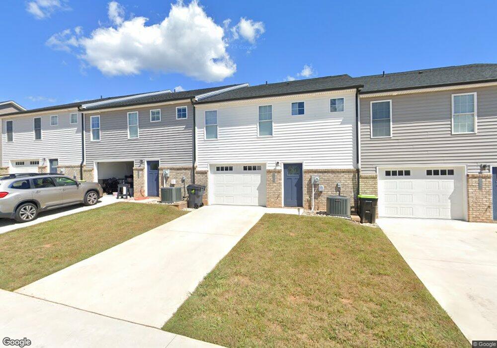
1064 Brownstone Ln Forest, VA 24551
Estimated Value: $340,000 - $366,134
Studio
3
Baths
--
Sq Ft
2,614
Sq Ft Lot
About This Home
This home is located at 1064 Brownstone Ln, Forest, VA 24551 and is currently estimated at $349,284. 1064 Brownstone Ln is a home located in Bedford County with nearby schools including Forest Elementary School, Forest Middle School, and Jefferson Forest High School.
Ownership History
Date
Name
Owned For
Owner Type
Purchase Details
Closed on
Mar 8, 2023
Sold by
Shamrock Construction Enterprises Inc
Bought by
Henson Ryan Patrick and Henson Haleigh Breanne
Current Estimated Value
Home Financials for this Owner
Home Financials are based on the most recent Mortgage that was taken out on this home.
Original Mortgage
$308,275
Outstanding Balance
$298,597
Interest Rate
6.13%
Mortgage Type
New Conventional
Estimated Equity
$50,687
Purchase Details
Closed on
May 18, 2022
Sold by
Ivey Creek Farms Inc
Bought by
Shamrock Construction Enterprises Inc
Create a Home Valuation Report for This Property
The Home Valuation Report is an in-depth analysis detailing your home's value as well as a comparison with similar homes in the area
Home Values in the Area
Average Home Value in this Area
Purchase History
| Date | Buyer | Sale Price | Title Company |
|---|---|---|---|
| Henson Ryan Patrick | $324,500 | -- | |
| Shamrock Construction Enterprises Inc | -- | Higginbotham James H |
Source: Public Records
Mortgage History
| Date | Status | Borrower | Loan Amount |
|---|---|---|---|
| Open | Henson Ryan Patrick | $308,275 |
Source: Public Records
Tax History
| Year | Tax Paid | Tax Assessment Tax Assessment Total Assessment is a certain percentage of the fair market value that is determined by local assessors to be the total taxable value of land and additions on the property. | Land | Improvement |
|---|---|---|---|---|
| 2025 | $1,312 | $320,000 | $45,000 | $275,000 |
| 2024 | $1,312 | $320,000 | $45,000 | $275,000 |
| 2023 | $1,312 | $160,000 | $0 | $0 |
| 2022 | $150 | $15,000 | $0 | $0 |
| 2021 | $150 | $30,000 | $30,000 | $0 |
| 2020 | $150 | $30,000 | $30,000 | $0 |
| 2019 | $150 | $30,000 | $30,000 | $0 |
| 2018 | $182 | $35,000 | $35,000 | $0 |
| 2017 | $182 | $35,000 | $35,000 | $0 |
| 2016 | $182 | $35,000 | $35,000 | $0 |
| 2015 | $182 | $35,000 | $35,000 | $0 |
| 2014 | $146 | $28,000 | $28,000 | $0 |
Source: Public Records
Map
Nearby Homes
- 0 Brewington Dr
- 0 Brewington Dr
- 1267 Harborough Dr
- 1384 Helmsdale Dr
- 1225 Commonwealth Cir
- 1543 Farmington Dr
- 1300 Stoney Ridge Blvd Unit 208
- 0 Farmington Dr
- 0 Dayna Ct
- 0 Lejack Cir
- 0 Lejack Cir Unit 333233
- 0 Whispering Springs Ct
- 0 Whispering Springs Ct
- 0 Whispering Springs Ct
- 1020 Easton Ct
- 1010 Coles Ct
- 1089 S Westyn Loop
- 1101 S Westyn Loop
- 1113 S Westyn Loop
- 87-LOT S Westyn Loop
- 1064 Brownstone Ln
- 1068 Brownstone Ln
- 1058 Brownstone Ln
- 1058 Brownstone Ln
- 1054 Brownstone Ln
- 1074 Brownstone Ln
- 1074 Brownstone Ln
- 1054-Lot 21 Brownstone Ln
- 1078 Brownstone Ln
- 1078-Lot 16 Brownstone Ln
- 1068-Lot 18 Brownstone Ln
- 1040 Brownstone Ln
- 1084 Brownstone Ln
- 1084-Lot 15 Brownstone Ln
- 1058 Cobblestone Ln
- 1074 Cobblestone Ln
- 1066 Cobblestone Ln
- 1050 Cobblestone Ln
- 1082 Cobblestone Ln
- 936 Brewington Dr
Your Personal Tour Guide
Ask me questions while you tour the home.