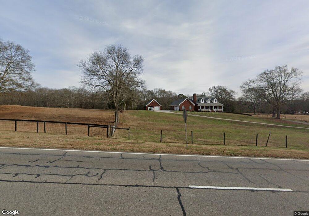
1064 Monroe Hwy Bethlehem, GA 30620
Estimated Value: $544,000 - $717,000
--
Bed
3
Baths
3,468
Sq Ft
$181/Sq Ft
Est. Value
About This Home
This home is located at 1064 Monroe Hwy, Bethlehem, GA 30620 and is currently estimated at $628,628, approximately $181 per square foot. 1064 Monroe Hwy is a home located in Barrow County with nearby schools including Bethlehem Elementary School, Haymon-Morris Middle School, and Apalachee High School.
Ownership History
Date
Name
Owned For
Owner Type
Purchase Details
Closed on
Dec 22, 2005
Sold by
Harrison E Charles
Bought by
Jones William A
Current Estimated Value
Home Financials for this Owner
Home Financials are based on the most recent Mortgage that was taken out on this home.
Original Mortgage
$49,500
Interest Rate
6.28%
Mortgage Type
Trade
Create a Home Valuation Report for This Property
The Home Valuation Report is an in-depth analysis detailing your home's value as well as a comparison with similar homes in the area
Home Values in the Area
Average Home Value in this Area
Purchase History
| Date | Buyer | Sale Price | Title Company |
|---|---|---|---|
| Jones William A | $99,500 | -- |
Source: Public Records
Mortgage History
| Date | Status | Borrower | Loan Amount |
|---|---|---|---|
| Closed | Jones William A | $49,500 |
Source: Public Records
Tax History Compared to Growth
Tax History
| Year | Tax Paid | Tax Assessment Tax Assessment Total Assessment is a certain percentage of the fair market value that is determined by local assessors to be the total taxable value of land and additions on the property. | Land | Improvement |
|---|---|---|---|---|
| 2024 | $4,417 | $236,361 | $28,345 | $208,016 |
| 2023 | $1,888 | $148,983 | $22,676 | $126,307 |
| 2022 | $2,648 | $148,983 | $22,676 | $126,307 |
| 2021 | $2,831 | $148,983 | $22,676 | $126,307 |
| 2020 | $2,424 | $135,381 | $19,736 | $115,645 |
| 2019 | $2,491 | $135,381 | $19,736 | $115,645 |
| 2018 | $2,451 | $135,415 | $19,736 | $115,679 |
| 2017 | $3,525 | $121,056 | $19,736 | $101,320 |
| 2016 | $3,432 | $117,566 | $19,736 | $97,830 |
| 2015 | $3,476 | $118,647 | $19,736 | $98,911 |
| 2014 | $3,477 | $115,922 | $15,867 | $100,054 |
| 2013 | -- | $112,249 | $17,630 | $94,619 |
Source: Public Records
Map
Nearby Homes
- 0 McElhannon Rd SW Unit 10581793
- 1408 Wyndham Way
- 1217 Cabin Bridge Rd
- 1109 Ravenwood Dr
- 1101 Ravenwood Dr
- 303 Carly Ct
- 784 Manger Ave
- 164 Manning Gin Rd
- 1050 Bethlehem Church Rd
- 449 & 455 Carl-Bethlehem Rd
- 0 Manger Ave E Unit 20154677
- 0 Manger Ave E Unit 20127001
- 468 Grand Oaks Ave
- 724 Manger Ave
- 0 Tanners Bridge Cr
- 3800 George Williams Rd
- 755 Harry McCarty Rd
- 824 Pruitt Rd
- 0 Tanners Bridge Cir Unit 10536031
- 0 Tanners Bridge Cir Unit 10395514
- 1065 Monroe Hwy
- 1040 Monroe Hwy
- 1088 Monroe Hwy
- 1105 Monroe Hwy
- 1021 Monroe Hwy
- 1300 Bethlehem Church Rd
- 1300 Bethlehem Church Rd Unit SUITE 204
- 1300 Bethlehem Church Rd
- 1015 Monroe Hwy
- 1001 Monroe Hwy
- 0 Monroe Highway 11
- 1133 Monroe Hwy
- 226 McElhannon Rd SW
- 1281 Bethlehem Church Rd
- 1281 Bethlehem Church Rd Unit N/
- 1252 Bethlehem Church Rd
- 989 Monroe Hwy
- 186 McElhannon Rd SW
- 1269 Bethlehem Church Rd
- 992 Monroe Hwy