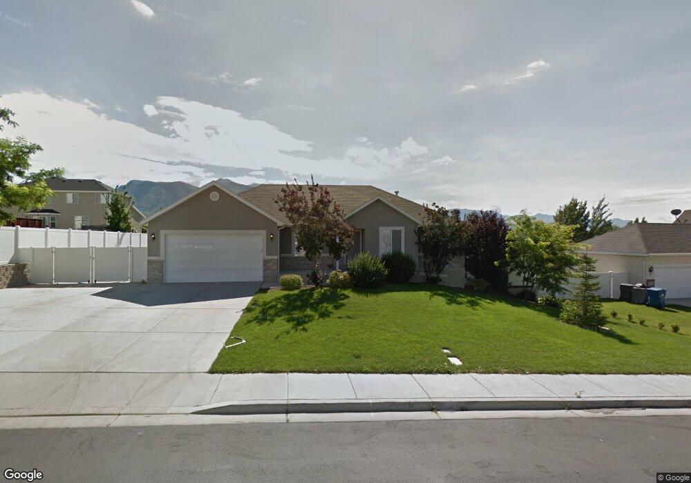
1064 N 420 W American Fork, UT 84003
Estimated Value: $574,000 - $641,000
3
Beds
2
Baths
2,850
Sq Ft
$218/Sq Ft
Est. Value
About This Home
This home is located at 1064 N 420 W, American Fork, UT 84003 and is currently estimated at $620,606, approximately $217 per square foot. 1064 N 420 W is a home located in Utah County with nearby schools including Shelley Elementary School, American Fork Junior High School, and American Fork High School.
Ownership History
Date
Name
Owned For
Owner Type
Purchase Details
Closed on
Apr 26, 2021
Sold by
Edwards Preston
Bought by
Edwards Preston and Edwards Abbey
Current Estimated Value
Home Financials for this Owner
Home Financials are based on the most recent Mortgage that was taken out on this home.
Original Mortgage
$255,500
Outstanding Balance
$231,185
Interest Rate
3%
Mortgage Type
New Conventional
Estimated Equity
$389,421
Purchase Details
Closed on
May 21, 2015
Sold by
Harr Daniel J
Bought by
Edwards Preston
Home Financials for this Owner
Home Financials are based on the most recent Mortgage that was taken out on this home.
Original Mortgage
$279,837
Interest Rate
4.25%
Mortgage Type
FHA
Purchase Details
Closed on
Nov 22, 2002
Sold by
Salisbury Development Lc
Bought by
Cook Preston W and Cook Janell
Home Financials for this Owner
Home Financials are based on the most recent Mortgage that was taken out on this home.
Original Mortgage
$154,700
Interest Rate
6.12%
Create a Home Valuation Report for This Property
The Home Valuation Report is an in-depth analysis detailing your home's value as well as a comparison with similar homes in the area
Home Values in the Area
Average Home Value in this Area
Purchase History
| Date | Buyer | Sale Price | Title Company |
|---|---|---|---|
| Edwards Preston | -- | Titan Title | |
| Edwards Preston | -- | Titan Title Ins Agency | |
| Edwards Preston | -- | Highland Title | |
| Cook Preston W | -- | Provo Land Title Company |
Source: Public Records
Mortgage History
| Date | Status | Borrower | Loan Amount |
|---|---|---|---|
| Open | Edwards Preston | $255,500 | |
| Closed | Edwards Preston | $255,500 | |
| Previous Owner | Edwards Preston | $279,837 | |
| Previous Owner | Cook Preston W | $154,700 |
Source: Public Records
Tax History Compared to Growth
Tax History
| Year | Tax Paid | Tax Assessment Tax Assessment Total Assessment is a certain percentage of the fair market value that is determined by local assessors to be the total taxable value of land and additions on the property. | Land | Improvement |
|---|---|---|---|---|
| 2025 | $2,459 | $541,700 | $222,800 | $318,900 |
| 2024 | $2,459 | $273,240 | $0 | $0 |
| 2023 | $2,324 | $273,735 | $0 | $0 |
| 2022 | $2,516 | $292,490 | $0 | $0 |
| 2021 | $2,156 | $391,400 | $159,900 | $231,500 |
| 2020 | $2,017 | $355,200 | $142,800 | $212,400 |
| 2019 | $1,867 | $340,000 | $132,100 | $207,900 |
| 2018 | $1,755 | $305,700 | $124,900 | $180,800 |
| 2017 | $1,685 | $158,345 | $0 | $0 |
| 2016 | $1,662 | $145,145 | $0 | $0 |
| 2015 | $1,668 | $138,270 | $0 | $0 |
| 2014 | $1,570 | $128,315 | $0 | $0 |
Source: Public Records
Map
Nearby Homes
- 471 W 1040 N
- 987 N 410 W
- 3667 W 950 Cir N Unit 217
- 3729 W 950 Cir N Unit 223
- 3687 W 950 Cir N Unit 221
- 3889 W 950 Cir N Unit 366
- 914 N 400 W Unit A
- 984 N 300 W
- 844 N 580 W
- 602 W 860 N
- 697 W 1040 N
- 796 N 200 W
- 1438 N 400 W
- 782 N 200 W
- 4007 W 1000 N
- 3932 W 1000 N Unit 434
- 3936 W 1000 N Unit 433
- 3962 W 1000 N Unit 428
- 3944 W 1000 N Unit 431
- 3940 W 1000 N Unit 432