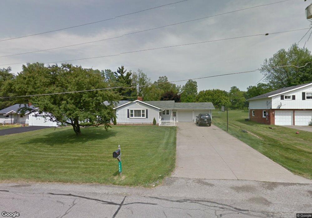
1064 Walcrest Dr Mansfield, OH 44903
Estimated Value: $174,000 - $207,150
3
Beds
2
Baths
1,316
Sq Ft
$145/Sq Ft
Est. Value
About This Home
This home is located at 1064 Walcrest Dr, Mansfield, OH 44903 and is currently estimated at $190,288, approximately $144 per square foot. 1064 Walcrest Dr is a home located in Richland County with nearby schools including Stingel Elementary School, Ontario Middle School, and Ontario High School.
Ownership History
Date
Name
Owned For
Owner Type
Purchase Details
Closed on
Nov 18, 1994
Sold by
O'leary Rose L
Bought by
Dretzka Robert W and Dretzka Deborah A
Current Estimated Value
Home Financials for this Owner
Home Financials are based on the most recent Mortgage that was taken out on this home.
Original Mortgage
$76,000
Interest Rate
8.91%
Mortgage Type
New Conventional
Create a Home Valuation Report for This Property
The Home Valuation Report is an in-depth analysis detailing your home's value as well as a comparison with similar homes in the area
Home Values in the Area
Average Home Value in this Area
Purchase History
We collect this data history from publicly available records. To have your information removed, we recommend requesting removal directly through your county’s website.
| Date | Buyer | Sale Price | Title Company |
|---|---|---|---|
| Dretzka Robert W | $80,000 | -- |
Source: Public Records
Mortgage History
We collect this data history from publicly available records. To have your information removed, we recommend requesting removal directly through your county’s website.
| Date | Status | Borrower | Loan Amount |
|---|---|---|---|
| Closed | Dretzka Robert W | $76,000 |
Source: Public Records
Tax History
| Year | Tax Paid | Tax Assessment Tax Assessment Total Assessment is a certain percentage of the fair market value that is determined by local assessors to be the total taxable value of land and additions on the property. | Land | Improvement |
|---|---|---|---|---|
| 2025 | $2,160 | $43,400 | $8,630 | $34,770 |
| 2024 | $2,160 | $43,400 | $8,630 | $34,770 |
| 2023 | $2,209 | $43,400 | $8,630 | $34,770 |
| 2022 | $2,077 | $35,100 | $7,850 | $27,250 |
| 2021 | $2,080 | $35,100 | $7,850 | $27,250 |
| 2020 | $2,218 | $35,100 | $7,850 | $27,250 |
| 2019 | $2,063 | $29,740 | $6,650 | $23,090 |
| 2018 | $1,762 | $29,740 | $6,650 | $23,090 |
| 2017 | $1,734 | $29,740 | $6,650 | $23,090 |
| 2016 | $1,784 | $30,430 | $6,450 | $23,980 |
| 2015 | $1,784 | $30,430 | $6,450 | $23,980 |
| 2014 | $1,782 | $30,430 | $6,450 | $23,980 |
| 2012 | $1,672 | $31,370 | $6,650 | $24,720 |
Source: Public Records
Map
Nearby Homes
- 0 Ohio 314
- 1689 Ohio 314
- 0 Rudy Rd
- 3560 Park Ave W
- 3710 Shangri la Ave E
- 3821 Horizon Dr
- 3308 Park Ave W
- 1684 Rock Rd
- 3320 Oakstone Dr
- 4418 Hook Rd
- 3516 Muirfield
- 3516 Muirfield Dr
- 5395 Lincoln Hwy
- 0 Rock Rd
- 2583 Deerfield Ln
- 3774 Millsboro Rd W Unit 3776
- 1129 Bogey Dr
- 2465 Ferguson Rd
- 855 Bowers Rd
- 3270 Sherman Rd
- 1074 Walcrest Dr
- 1054 Walcrest Dr
- 1044 Walcrest Dr
- 1065 Walcrest Dr
- 1055 Walcrest Dr
- 1075 Walcrest Dr
- 1094 Walcrest Dr
- 1034 Walcrest Dr
- 1085 Walcrest Dr
- 1104 Walcrest Dr
- 1035 Walcrest Dr
- 1105 Walcrest Dr
- 1114 Walcrest Dr
- 1115 Walcrest Dr
- 1124 Walcrest Dr
- 4025 Snodgrass Rd
- 4115 Snodgrass Rd
- 4115 Snodgrass Rd
- 4092 Snodgrass Rd
- 0 Walcrest Dr
Your Personal Tour Guide
Ask me questions while you tour the home.