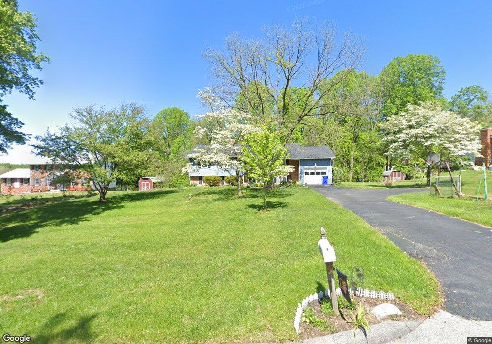
10642 Breezewood Dr Woodstock, MD 21163
Estimated Value: $610,000 - $685,000
--
Bed
3
Baths
1,320
Sq Ft
$495/Sq Ft
Est. Value
About This Home
This home is located at 10642 Breezewood Dr, Woodstock, MD 21163 and is currently estimated at $653,919, approximately $495 per square foot. 10642 Breezewood Dr is a home located in Howard County with nearby schools including Waverly Elementary School, Mount View Middle School, and Marriotts Ridge High School.
Ownership History
Date
Name
Owned For
Owner Type
Purchase Details
Closed on
Oct 26, 2022
Sold by
Zimmermann Bruce A and Zimmermann Margaret S
Bought by
Bruce A Zimmermann And Margaret S Zimmermann
Current Estimated Value
Purchase Details
Closed on
Jan 14, 1997
Sold by
Prudential Residential Services
Bought by
Zimmerman Bruce A and Zimmerman Margaret S
Purchase Details
Closed on
Nov 13, 1996
Sold by
Soper Richard S
Bought by
Prudential Residential Services and Limited Partnership
Purchase Details
Closed on
Jan 6, 1988
Sold by
Swift Wayne E and Swift Wf
Bought by
Soper Richard S
Create a Home Valuation Report for This Property
The Home Valuation Report is an in-depth analysis detailing your home's value as well as a comparison with similar homes in the area
Home Values in the Area
Average Home Value in this Area
Purchase History
| Date | Buyer | Sale Price | Title Company |
|---|---|---|---|
| Bruce A Zimmermann And Margaret S Zimmermann | -- | None Listed On Document | |
| Bruce A Zimmermann And Margaret S Zimmermann | -- | None Listed On Document | |
| Zimmerman Bruce A | $174,450 | -- | |
| Prudential Residential Services | $175,500 | -- | |
| Soper Richard S | $148,000 | -- |
Source: Public Records
Tax History Compared to Growth
Tax History
| Year | Tax Paid | Tax Assessment Tax Assessment Total Assessment is a certain percentage of the fair market value that is determined by local assessors to be the total taxable value of land and additions on the property. | Land | Improvement |
|---|---|---|---|---|
| 2025 | $6,681 | $478,100 | $0 | $0 |
| 2024 | $6,681 | $443,700 | $219,900 | $223,800 |
| 2023 | $6,292 | $426,867 | $0 | $0 |
| 2022 | $6,024 | $410,033 | $0 | $0 |
| 2021 | $5,787 | $393,200 | $200,900 | $192,300 |
| 2020 | $5,787 | $392,567 | $0 | $0 |
| 2019 | $5,778 | $391,933 | $0 | $0 |
| 2018 | $5,455 | $391,300 | $161,900 | $229,400 |
| 2017 | $5,297 | $391,300 | $0 | $0 |
| 2016 | -- | $370,033 | $0 | $0 |
| 2015 | -- | $359,400 | $0 | $0 |
| 2014 | -- | $359,400 | $0 | $0 |
Source: Public Records
Map
Nearby Homes
- 10655 Breezewood Dr
- 1800 Mount Denali Dr
- 1502 Grooms Ln
- 10715 Taylor Farm Rd
- 1725 Marriottsville Rd
- 11100 Chambers Ct Unit C
- 11100 Chambers Ct Unit F
- 11100 Chambers Ct Unit K
- 11110 Chambers Ct Unit A
- 11120 Chambers Ct Unit Q
- 10682 Hillingdon Rd
- 11150 Chambers Ct Unit H
- 2208 Merion Pond
- 2115 Ganton Green Unit G106
- 2111 Ganton Green
- 10225 Green Clover Dr
- 10170 Green Clover Dr
- 2740 Emma Stone Dr
- 10174 Tracy Beth Ct
- 10205 Cabery Rd
- 10648 Breezewood Dr
- 10636 Breezewood Dr
- 10654 Breezewood Dr
- 10633 Breezewood Cir
- 10639 Breezewood Dr
- 10629 Breezewood Dr
- 10660 Breezewood Dr
- 10647 Breezewood Dr
- 10643 Breezewood Dr
- 10631 Breezewood Dr
- 10651 Breezewood Dr
- 10634 Breezewood Cir
- 10635 Breezewood Dr
- 10627 Breezewood Dr
- 10630 Breezewood Cir
- 1682 Woodstock Rd
- 1720 Woodstock Rd
- 10659 Breezewood Dr
- 10626 Breezewood Cir
- 10623 Breezewood Dr