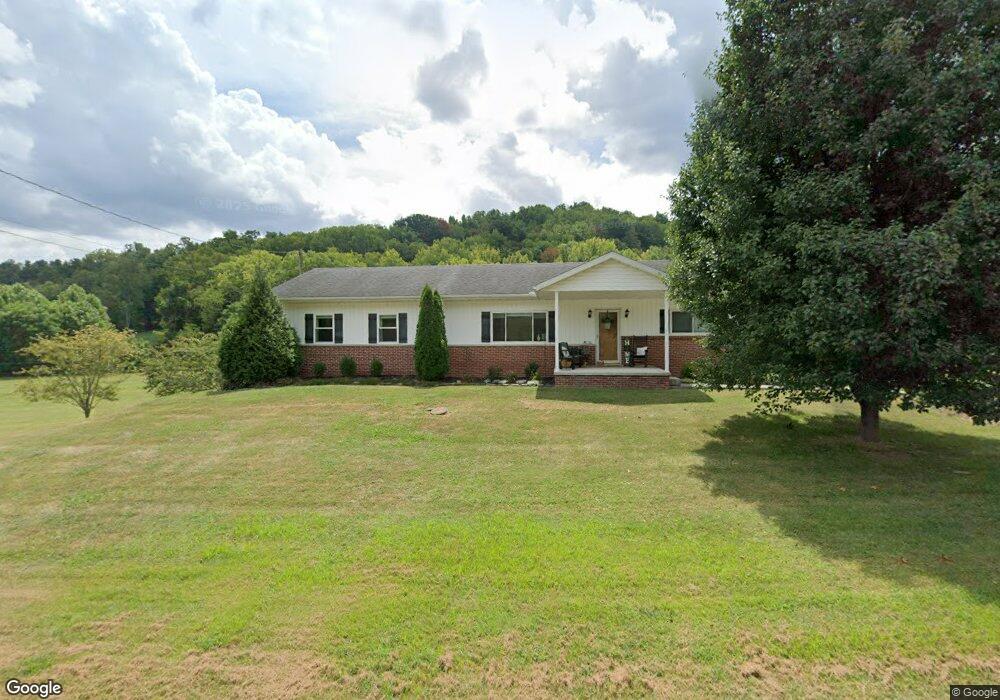
10644 State Route 243 South Point, OH 45680
Estimated Value: $226,000 - $291,717
2
Beds
2
Baths
1,736
Sq Ft
$144/Sq Ft
Est. Value
About This Home
This home is located at 10644 State Route 243, South Point, OH 45680 and is currently estimated at $249,572, approximately $143 per square foot. 10644 State Route 243 is a home located in Lawrence County with nearby schools including Dawson-Bryant Elementary School, Dawson-Bryant Middle School, and Dawson-Bryant High School.
Ownership History
Date
Name
Owned For
Owner Type
Purchase Details
Closed on
Jul 18, 2005
Sold by
Moore Barbara A and Miller Danny C
Bought by
Hamm R Scott and Hamm Katherine A
Current Estimated Value
Home Financials for this Owner
Home Financials are based on the most recent Mortgage that was taken out on this home.
Original Mortgage
$164,000
Outstanding Balance
$85,886
Interest Rate
5.71%
Mortgage Type
Purchase Money Mortgage
Estimated Equity
$163,686
Purchase Details
Closed on
Jul 13, 2005
Sold by
Drummond Jerry D
Bought by
Hamm R Scott and Hamm Katherine A
Home Financials for this Owner
Home Financials are based on the most recent Mortgage that was taken out on this home.
Original Mortgage
$164,000
Outstanding Balance
$85,886
Interest Rate
5.71%
Mortgage Type
Purchase Money Mortgage
Estimated Equity
$163,686
Create a Home Valuation Report for This Property
The Home Valuation Report is an in-depth analysis detailing your home's value as well as a comparison with similar homes in the area
Home Values in the Area
Average Home Value in this Area
Purchase History
| Date | Buyer | Sale Price | Title Company |
|---|---|---|---|
| Hamm R Scott | $153,750 | None Available | |
| Hamm R Scott | $51,250 | None Available |
Source: Public Records
Mortgage History
| Date | Status | Borrower | Loan Amount |
|---|---|---|---|
| Open | Hamm R Scott | $164,000 | |
| Closed | Hamm R Scott | $164,000 |
Source: Public Records
Tax History Compared to Growth
Tax History
| Year | Tax Paid | Tax Assessment Tax Assessment Total Assessment is a certain percentage of the fair market value that is determined by local assessors to be the total taxable value of land and additions on the property. | Land | Improvement |
|---|---|---|---|---|
| 2024 | -- | $57,560 | $23,070 | $34,490 |
| 2023 | $1,235 | $57,560 | $23,070 | $34,490 |
| 2022 | $1,232 | $57,560 | $23,070 | $34,490 |
| 2021 | $1,091 | $44,640 | $15,130 | $29,510 |
| 2020 | $1,106 | $44,640 | $15,130 | $29,510 |
| 2019 | $1,102 | $44,640 | $15,130 | $29,510 |
| 2018 | $1,151 | $43,620 | $14,830 | $28,790 |
| 2017 | $1,148 | $43,620 | $14,830 | $28,790 |
| 2016 | $1,064 | $43,620 | $14,830 | $28,790 |
| 2015 | $1,163 | $44,090 | $14,850 | $29,240 |
| 2014 | $1,037 | $40,170 | $14,850 | $25,320 |
| 2013 | $793 | $31,570 | $14,850 | $16,720 |
Source: Public Records
Map
Nearby Homes
- 9040 Ohio 243
- 3493 County Road 31
- 66 County Road 30
- 3171 County Road 31
- 71 Private Dr
- 66 Township Road 1523
- 25 Township Road 1524
- 1334 McKinney Creek-Hesson Hollow Rd N
- 1334 Township Road 214th N
- 6881 State Route 243
- 6757 County Road 15
- 6897 County Road 15
- 1122 Township Road 266
- 1122 Township Road 266
- 4404 County Road 15
- 181 Private Road 3954
- 00 Township Road 219 N
- 983 County Road 104
- 3569 County Road 6
- 7428 County Road 15
- 38 County Road 30
- 10846 State Route 243
- 10817 State Route 243
- 167 County Road 30
- 242 County Road 30
- 10436 State Route 243
- 11065 State Route 243
- 11065 State Route 243
- 3518 Township Road 250
- 13 Twp Rd 346
- 11119 State Route 243
- 474 County Road 30
- 332 County Road 30
- 91 Township Road 346
- 3932 Township Road 250
- 135 Township Road 346
- 3906 Township Road 250
- 3870 Township Road 250
- 10286 State Route 243