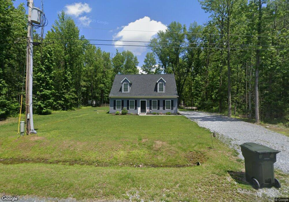
10645 Watonga Rd Chestertown, MD 21620
Estimated Value: $318,000 - $347,000
--
Bed
--
Bath
1,404
Sq Ft
$236/Sq Ft
Est. Value
About This Home
This home is located at 10645 Watonga Rd, Chestertown, MD 21620 and is currently estimated at $331,719, approximately $236 per square foot. 10645 Watonga Rd is a home located in Kent County with nearby schools including Center for Innovation, Kent County Middle School, and Kent County High School.
Ownership History
Date
Name
Owned For
Owner Type
Purchase Details
Closed on
May 18, 2020
Sold by
C D Reed & Sons Association
Bought by
Richards Brandon and Demers Sarah
Current Estimated Value
Home Financials for this Owner
Home Financials are based on the most recent Mortgage that was taken out on this home.
Original Mortgage
$208,050
Outstanding Balance
$184,361
Interest Rate
3.3%
Mortgage Type
New Conventional
Estimated Equity
$147,358
Purchase Details
Closed on
Jul 17, 2019
Sold by
Reed Charles D and Reed Roger L
Bought by
C D Reed & Sons Associates
Purchase Details
Closed on
Apr 23, 2003
Sold by
Cech Frank A
Bought by
Reed Charles Dudley
Create a Home Valuation Report for This Property
The Home Valuation Report is an in-depth analysis detailing your home's value as well as a comparison with similar homes in the area
Home Values in the Area
Average Home Value in this Area
Purchase History
| Date | Buyer | Sale Price | Title Company |
|---|---|---|---|
| Richards Brandon | $219,000 | The Atlantic Title Group | |
| C D Reed & Sons Associates | $25,000 | None Available | |
| Reed Charles Dudley | $1,500 | -- |
Source: Public Records
Mortgage History
| Date | Status | Borrower | Loan Amount |
|---|---|---|---|
| Open | Richards Brandon | $208,050 |
Source: Public Records
Tax History Compared to Growth
Tax History
| Year | Tax Paid | Tax Assessment Tax Assessment Total Assessment is a certain percentage of the fair market value that is determined by local assessors to be the total taxable value of land and additions on the property. | Land | Improvement |
|---|---|---|---|---|
| 2025 | $2,390 | $210,800 | $61,200 | $149,600 |
| 2024 | $2,312 | $203,867 | $0 | $0 |
| 2023 | $2,233 | $196,933 | $0 | $0 |
| 2022 | $2,136 | $190,000 | $61,200 | $128,800 |
| 2021 | $4,200 | $190,000 | $61,200 | $128,800 |
| 2020 | $1,030 | $190,000 | $61,200 | $128,800 |
| 2019 | $2,300 | $50,700 | $50,700 | $0 |
| 2018 | $1,150 | $50,700 | $50,700 | $0 |
| 2017 | $575 | $50,700 | $0 | $0 |
| 2016 | -- | $50,700 | $0 | $0 |
| 2015 | $694 | $50,700 | $0 | $0 |
| 2014 | $694 | $50,700 | $0 | $0 |
Source: Public Records
Map
Nearby Homes
- 0 Tonopah Rd Unit MDKE2005470
- 0 Tonopah Rd Unit MDKE2005564
- 0 Cogar Rd Unit MDKE2005472
- 0 Lenapah Rd
- 10751 Millbrook Dr
- 0 Lot 24 & 25 Buck Neck Rd Unit MDKE2004828
- 0 Redfield Rd Unit MDKE2002842
- Parcel Buck Neck Ldg Rd
- 0 Towhee Rd
- 0 Sheldrake Dr
- 0 Kinglet Rd
- 23710 L Rd
- 0 Bunting Rd
- 0 Cloquet Rd Unit MDKE2005966
- 0 Melitota Ln
- LOTS 253-254 Carimon Rd
- 0 Spinnaker Rd
- 0 Sandpiper Rd Unit MDKE2005542
- 0 Beltram Rd
- 0 Buck Neck Rd Unit MDKE2005262
- 10656 Millbrook Dr
- 10652 Watonga Rd
- 10634 Millbrook Dr
- 10632 Watonga Rd
- 23610 Keane Rd
- 10661 Millbrook Dr
- 10672 Watonga Rd
- 10645 Tonopah Rd
- 10673 Millbrook Dr
- 10605 Watonga Rd
- 10605 Tonopah Rd
- 10639 Millbrook Dr
- 10681 Millbrook Dr
- 0 Tonopah Rd Unit 1000269730
- 0 Tonopah Rd Unit 1007210696
- 0 Tonopah Rd Unit 1006926352
- 0 Tonopah Rd Unit 1006736356
- 0 Tonopah Rd Unit MDKE2004994
- 0 Tonopah Rd Unit MDKE2002170
- 0 Tonopah Rd Unit 1000083931