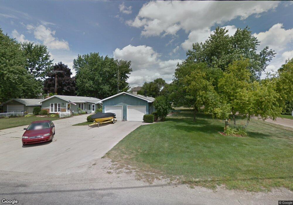
10649 Hewitt Rd Brooklyn, MI 49230
Estimated Value: $177,000 - $285,779
3
Beds
2
Baths
1,440
Sq Ft
$176/Sq Ft
Est. Value
About This Home
This home is located at 10649 Hewitt Rd, Brooklyn, MI 49230 and is currently estimated at $253,445, approximately $176 per square foot. 10649 Hewitt Rd is a home located in Jackson County with nearby schools including Columbia Lower Elementary School, Columbia Upper Elementary School, and Columbia Central Jr./Sr. High School.
Ownership History
Date
Name
Owned For
Owner Type
Purchase Details
Closed on
Mar 30, 2020
Sold by
First National Acceptance Company
Bought by
Smith Stewart Aaron
Current Estimated Value
Purchase Details
Closed on
Jan 26, 2016
Sold by
Clark David W and Ernst Clark Susan E
Bought by
First National Acceptance Company
Purchase Details
Closed on
Feb 10, 2014
Sold by
Camp Ronald E
Bought by
Clark David
Purchase Details
Closed on
Feb 17, 1995
Sold by
Collins William and Collins Peggy
Bought by
Camp Ronald
Create a Home Valuation Report for This Property
The Home Valuation Report is an in-depth analysis detailing your home's value as well as a comparison with similar homes in the area
Home Values in the Area
Average Home Value in this Area
Purchase History
| Date | Buyer | Sale Price | Title Company |
|---|---|---|---|
| Smith Stewart Aaron | $120,000 | None Available | |
| First National Acceptance Company | -- | At | |
| Clark David | $99,000 | None Available | |
| Camp Ronald | $79,000 | -- |
Source: Public Records
Tax History Compared to Growth
Tax History
| Year | Tax Paid | Tax Assessment Tax Assessment Total Assessment is a certain percentage of the fair market value that is determined by local assessors to be the total taxable value of land and additions on the property. | Land | Improvement |
|---|---|---|---|---|
| 2025 | $1,998 | $110,100 | $0 | $0 |
| 2024 | $1,310 | $106,800 | $0 | $0 |
| 2023 | $1,248 | $96,400 | $0 | $0 |
| 2022 | $1,814 | $80,900 | $0 | $0 |
| 2021 | $1,791 | $72,900 | $0 | $0 |
| 2020 | $1,771 | $72,900 | $0 | $0 |
| 2019 | $1,728 | $61,200 | $0 | $0 |
| 2018 | $1,689 | $56,600 | $0 | $0 |
| 2017 | $1,601 | $54,900 | $0 | $0 |
| 2016 | $1,084 | $54,500 | $54,500 | $0 |
| 2015 | $2,438 | $41,700 | $41,700 | $0 |
| 2014 | $2,438 | $39,700 | $39,700 | $0 |
| 2013 | -- | $39,700 | $39,700 | $0 |
Source: Public Records
Map
Nearby Homes
- 116 Paula Dr
- 000 Hewitt Rd
- VL Carlysle Dr
- 9813 Peterson Rd
- 2903 Russell Ct
- 00 Ambler Dr
- 207 Ambler Dr
- V/L Ocean Beach Rd
- VL Kirkley Dr
- 0 Lot 44 & 45 Wilkshire Dr Unit 25044305
- 9538 Peterson Rd
- 200 Barbara Dr
- 2490 Lakeview Dr
- 99 Nottingham Dr
- 186 Bedford Dr
- 7943 Cement City Rd
- 2217 Shady Ln
- 215 Nottingham Dr
- 328 Ashley Ct Unit 13
- 112 Abbott Ln
- 10647 Hewitt Rd
- 10647 Hewitt Rd
- 139 Boyce Dr
- 144 Boyce Dr
- 111 Boyce Dr
- 10653 Hewitt Rd
- 10648 Hewitt Rd
- 10650 Hewitt Rd
- 140 Boyce Dr
- 140 Boyce Dr
- 10652 Hewitt Rd
- 10644 Hewitt Rd
- 10644 Hewitt Rd
- 0 Hewitt Unit Parcel B 1051225
- 0 Hewitt Unit Parcel D 1051226
- 0 Hewitt Unit 11966,Between 11962
- 0 Hewitt Unit 11966,Between 11962
- 103 Boyce Dr
- 103 Boyce Dr
- 103 Boyce Dr