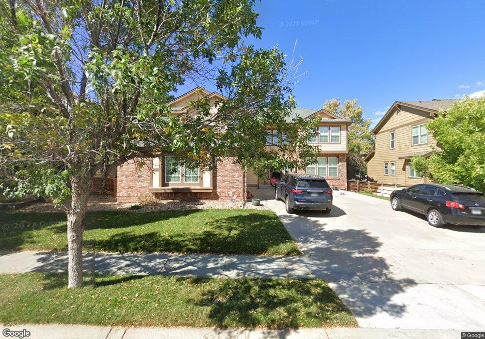
10651 Harmony Ln Commerce City, CO 80022
Reunion NeighborhoodEstimated Value: $585,996 - $708,000
4
Beds
3
Baths
2,813
Sq Ft
$225/Sq Ft
Est. Value
About This Home
This home is located at 10651 Harmony Ln, Commerce City, CO 80022 and is currently estimated at $632,749, approximately $224 per square foot. 10651 Harmony Ln is a home located in Adams County with nearby schools including Reunion Elementary School, Otho E Stuart Middle School, and Prairie View High School.
Ownership History
Date
Name
Owned For
Owner Type
Purchase Details
Closed on
Feb 26, 2004
Sold by
Lennar Colorado Llc
Bought by
Alexander Lanceferd L
Current Estimated Value
Home Financials for this Owner
Home Financials are based on the most recent Mortgage that was taken out on this home.
Original Mortgage
$252,150
Outstanding Balance
$117,844
Interest Rate
5.67%
Mortgage Type
Unknown
Estimated Equity
$514,905
Create a Home Valuation Report for This Property
The Home Valuation Report is an in-depth analysis detailing your home's value as well as a comparison with similar homes in the area
Home Values in the Area
Average Home Value in this Area
Purchase History
| Date | Buyer | Sale Price | Title Company |
|---|---|---|---|
| Alexander Lanceferd L | $315,229 | North American Title |
Source: Public Records
Mortgage History
| Date | Status | Borrower | Loan Amount |
|---|---|---|---|
| Open | Alexander Lanceferd L | $252,150 |
Source: Public Records
Tax History Compared to Growth
Tax History
| Year | Tax Paid | Tax Assessment Tax Assessment Total Assessment is a certain percentage of the fair market value that is determined by local assessors to be the total taxable value of land and additions on the property. | Land | Improvement |
|---|---|---|---|---|
| 2024 | $7,985 | $36,000 | $7,500 | $28,500 |
| 2023 | $7,960 | $41,400 | $7,440 | $33,960 |
| 2022 | $5,433 | $31,580 | $7,650 | $23,930 |
| 2021 | $5,318 | $31,580 | $7,650 | $23,930 |
| 2020 | $5,132 | $31,700 | $7,870 | $23,830 |
| 2019 | $5,131 | $31,700 | $7,870 | $23,830 |
| 2018 | $6,341 | $29,290 | $7,200 | $22,090 |
| 2017 | $6,191 | $29,290 | $7,200 | $22,090 |
| 2016 | $5,326 | $26,150 | $5,170 | $20,980 |
| 2015 | $5,324 | $26,150 | $5,170 | $20,980 |
| 2014 | -- | $22,270 | $4,300 | $17,970 |
Source: Public Records
Map
Nearby Homes
- 10609 Ouray Ct
- 16650 E 107th Ct
- 17045 E 105th Ave
- 16743 Parkside Dr S
- 16673 Parkside Dr S
- 10680 Norfolk St
- 16724 E 105th Ave
- 10671 Nucla Ct
- 10505 Richfield St
- 10440 Olathe St
- 17070 E 104th Place
- 10565 Memphis St
- 10550 Sedalia St
- 16580 E 104th Place
- 17310 E 104th Place
- 10978 Ouray St
- 16300 Fairway Dr Unit 28
- 10684 Lewiston St
- 17741 Parkside Dr N
- 10995 Quintero St
- 10625 Harmony Ln
- 10655 Harmony Ln
- 10654 Ouray Ct
- 10664 Ouray Ct
- 10634 Ouray Ct
- 10601 Harmony Ln
- 17008 E 106th Way
- 17007 E 106th Ave
- 10624 Ouray Ct
- 16979 E 106th Way
- 16999 E 106th Way
- 10604 Ouray Ct
- 17028 E 106th Way
- 17027 E 106th Ave
- 16959 E 106th Way
- 16996 E 106th Ave
- 10659 Ouray Ct
- 10649 Ouray Ct
- 10669 Ouray Ct
- 17009 E 106th Way