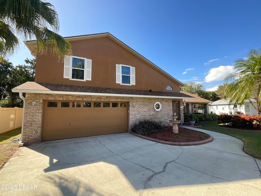
1066 Azalea Pointe Dr Port Orange, FL 32129
Port Orange West NeighborhoodEstimated payment $2,164/month
Highlights
- Main Floor Primary Bedroom
- Wrap Around Porch
- Eat-In Kitchen
- No HOA
- Cul-De-Sac
- Separate Shower in Primary Bathroom
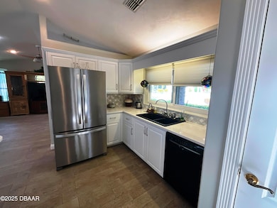
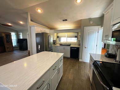
About This Home
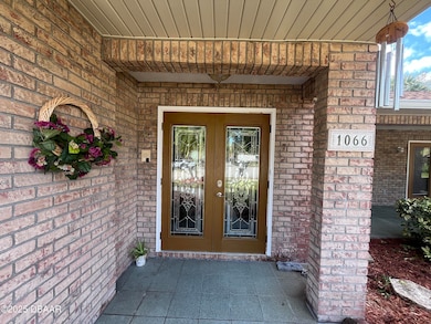
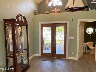
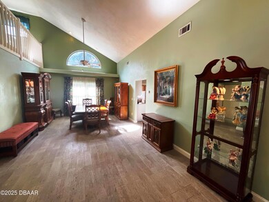
Beautifully maintained 3BR/2.5BA two-story home offering 2,366 sq ft of living space on a large pie-shaped lot at the end of a quiet cul-de-sac. Features include a first-floor primary suite, beautifully updated kitchen, and convenient indoor laundry. Enjoy peace of mind with an updated electric panel, updated water heater, newer roof, and updated windows. This home offers both comfort and efficiency in a prime location close to shopping, dining, banking, the YMCA, beaches, and parks. Easy access to I-95 and I-4 makes commuting to Orlando or St. Augustine a breeze. A perfect blend of space, style, and convenience!
Home Details
Home Type
- Single Family
Est. Annual Taxes
- $2,282
Year Built
- Built in 1994 | Remodeled
Lot Details
- 0.27 Acre Lot
- Cul-De-Sac
- North Facing Home
- Irregular Lot
- Front and Back Yard Sprinklers
Parking
- 2 Car Garage
- Garage Door Opener
Home Design
- Entry on the 1st floor
- Slab Foundation
- Shingle Roof
- Concrete Block And Stucco Construction
Interior Spaces
- 2,366 Sq Ft Home
- 2-Story Property
- Central Vacuum
- Ceiling Fan
- Entrance Foyer
- Family Room
- Living Room
- Dining Room
- Laundry on lower level
Kitchen
- Eat-In Kitchen
- Breakfast Bar
- Electric Oven
- Microwave
- Dishwasher
- Disposal
Flooring
- Carpet
- Tile
Bedrooms and Bathrooms
- 3 Bedrooms
- Primary Bedroom on Main
- Separate Shower in Primary Bathroom
Outdoor Features
- Wrap Around Porch
- Patio
Schools
- Sugar Mill Elementary School
- Silver Sands Middle School
- Atlantic High School
Utilities
- Zoned Heating and Cooling
- 200+ Amp Service
- Electric Water Heater
Community Details
- No Home Owners Association
- Azalea Pointe Subdivision
Listing and Financial Details
- Homestead Exemption
- Assessor Parcel Number 6317-22-00-0170
Map
Home Values in the Area
Average Home Value in this Area
Tax History
| Year | Tax Paid | Tax Assessment Tax Assessment Total Assessment is a certain percentage of the fair market value that is determined by local assessors to be the total taxable value of land and additions on the property. | Land | Improvement |
|---|---|---|---|---|
| 2025 | $2,222 | $171,456 | -- | -- |
| 2024 | $2,222 | $166,624 | -- | -- |
| 2023 | $2,222 | $161,771 | $0 | $0 |
| 2022 | $2,137 | $157,059 | $0 | $0 |
| 2021 | $2,177 | $152,484 | $0 | $0 |
| 2020 | $2,118 | $150,379 | $0 | $0 |
| 2019 | $2,045 | $146,998 | $0 | $0 |
| 2018 | $2,041 | $144,257 | $0 | $0 |
| 2017 | $2,044 | $141,290 | $0 | $0 |
| 2016 | $2,043 | $138,384 | $0 | $0 |
| 2015 | $2,103 | $137,422 | $0 | $0 |
| 2014 | $2,109 | $136,331 | $0 | $0 |
Property History
| Date | Event | Price | List to Sale | Price per Sq Ft |
|---|---|---|---|---|
| 11/06/2025 11/06/25 | For Sale | $375,000 | -- | $158 / Sq Ft |
Purchase History
| Date | Type | Sale Price | Title Company |
|---|---|---|---|
| Quit Claim Deed | -- | -- | |
| Warranty Deed | $135,000 | -- | |
| Warranty Deed | $25,000 | -- | |
| Deed | $75,000 | -- |
Mortgage History
| Date | Status | Loan Amount | Loan Type |
|---|---|---|---|
| Previous Owner | $121,500 | Purchase Money Mortgage | |
| Previous Owner | $85,000 | Purchase Money Mortgage |
Source: Daytona Beach Area Association of REALTORS®
MLS Number: 1219687
APN: 6317-22-00-0170
Disclaimer: Certain information contained herein is derived from information provided by parties other than Homes.com. All information provided is deemed reliable, but is not guaranteed to be accurate and should be independently verified.
![]() IDX information is provided exclusively for personal, non-commercial use, and may not be used for any purpose other than to identify prospective properties consumers may be interested in purchasing.
IDX information is provided exclusively for personal, non-commercial use, and may not be used for any purpose other than to identify prospective properties consumers may be interested in purchasing.
Information is deemed reliable but not guaranteed.
- 1057 Azalea Pointe Dr
- 1082 York Way
- 1077 Willow Wood Dr
- 1086 Donnell Dr
- 1075 Horizon View Blvd
- 1099 Kingswood Way
- 1118 Kane Dr
- 1105 Donnell Dr
- 1132 Loblolly Ln
- 1106 Blueberry Dr
- 993 Appleview Way
- 4041 S Waterbridge Cir
- 5912 Plainview Dr
- 1736 Dunlawton Ave
- 1228 Thomasina Dr
- 990 Waterford Point Dr
- 1245 Thomas Dr
- 800 Black Duck Dr
- 4015 N Waterbridge Cir
- 806 Black Duck Dr
- 4801 S Clyde Morris Blvd
- 5609 Victoria Gardens Blvd
- 1645 Dunlawton Ave
- 1223 Ryan St
- 3900 Yorktowne Blvd
- 340 Windsor Dr
- 908 Silver Leaf Place
- 1025 Eagle Lake Trail
- 38 Woodlake Dr
- 909 Bentwood Ln Unit 1
- 940 Village Trail Unit 8-205
- 81 Regency Dr Unit 81
- 941 Mill Road Ln
- 45 Bella Lago Cir
- 5410 S Williamson Blvd
- 456 Cecilia Dr Unit 456E
- 4 Bella Oaks Dr
- 455 Cecilia Dr Unit 455E
- 5400 S Williamson Blvd
- 980 Canal View Blvd Unit E5
