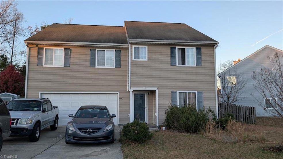
1067 Bridgend Dr High Point, NC 27260
Estimated payment $1,921/month
Highlights
- Outdoor Pool
- Porch
- Kitchen Island
- Attic
- 2 Car Attached Garage
- Outdoor Storage
About This Home
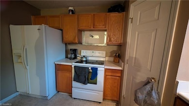
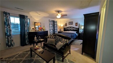
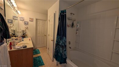
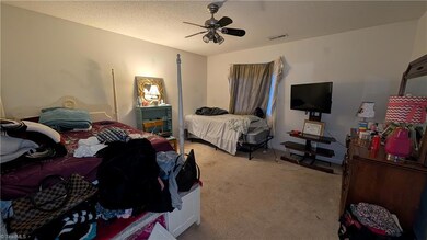
This corner-lot charmer is ready for its glow up! Will you be the one to make it shine? Whether you're looking to expand your rental empire or design the home of your dreams, this property is full of possibilities! Featuring 4 spacious bedrooms, 2.5 baths, and all bedrooms tucked away upstairs for peace and privacy. Large yard perfect for picnics or exploring, and yes, the storage building stays! Love to cook and entertain? This kitchen is practically begging for your personal flair- so get your hammer and nails and let the upgrades begin! So much potential to turn this into your home sweet home. Motivated seller! See agent only remarks.
Home Details
Home Type
- Single Family
Est. Annual Taxes
- $2,866
Year Built
- Built in 2005
Lot Details
- 0.34 Acre Lot
- Fenced
- Level Lot
- Property is zoned RS-9
Parking
- 2 Car Attached Garage
- Driveway
Home Design
- Slab Foundation
- Vinyl Siding
Interior Spaces
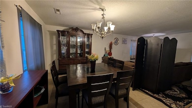
- 2,466 Sq Ft Home
- Property has 2 Levels
- Ceiling Fan
- Insulated Doors
- Storm Doors
- Kitchen Island
- Dryer Hookup
- Attic
Flooring
- Carpet
- Vinyl
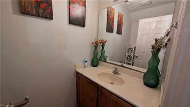
Bedrooms and Bathrooms
- 4 Bedrooms
Outdoor Features
- Outdoor Pool
- Outdoor Storage
- Porch
Utilities
- Forced Air Heating and Cooling System
- Heat Pump System
- Electric Water Heater
Listing and Financial Details
- Assessor Parcel Number 0212115
- 0% Total Tax Rate
Community Details
Overview
- Property has a Home Owners Association
- Broadstone Village Subdivision
Recreation
- Community Pool
Map
Home Values in the Area
Average Home Value in this Area
Tax History
| Year | Tax Paid | Tax Assessment Tax Assessment Total Assessment is a certain percentage of the fair market value that is determined by local assessors to be the total taxable value of land and additions on the property. | Land | Improvement |
|---|---|---|---|---|
| 2025 | $2,888 | $209,600 | $25,000 | $184,600 |
| 2024 | $2,888 | $209,600 | $25,000 | $184,600 |
| 2023 | $2,888 | $209,600 | $25,000 | $184,600 |
| 2022 | $2,825 | $209,600 | $25,000 | $184,600 |
| 2021 | $2,166 | $157,200 | $15,000 | $142,200 |
| 2020 | $2,166 | $157,200 | $15,000 | $142,200 |
| 2019 | $2,166 | $157,200 | $0 | $0 |
| 2018 | $2,155 | $157,200 | $0 | $0 |
| 2017 | $2,155 | $157,200 | $0 | $0 |
| 2016 | $1,819 | $129,700 | $0 | $0 |
| 2015 | $1,829 | $129,700 | $0 | $0 |
| 2014 | $1,860 | $129,700 | $0 | $0 |
Property History
| Date | Event | Price | List to Sale | Price per Sq Ft |
|---|---|---|---|---|
| 11/16/2025 11/16/25 | For Sale | $319,000 | -- | $129 / Sq Ft |
Purchase History
| Date | Type | Sale Price | Title Company |
|---|---|---|---|
| Interfamily Deed Transfer | -- | None Available | |
| Warranty Deed | $122,000 | None Available | |
| Warranty Deed | $140,500 | None Available |
Mortgage History
| Date | Status | Loan Amount | Loan Type |
|---|---|---|---|
| Open | $109,800 | New Conventional | |
| Previous Owner | $80,430 | Fannie Mae Freddie Mac |
Source: Triad MLS
MLS Number: 1202350
APN: 0212115
Disclaimer: Certain information contained herein is derived from information provided by parties other than Homes.com. All information provided is deemed reliable, but is not guaranteed to be accurate and should be independently verified.
![]() Copyright 2025 Triad MLS, Inc. All rights reserved. IDX information is provided exclusively for personal, non-commercial use, and may not be used for any purpose other than to identify prospective properties consumers may be interested in purchasing. Information is deemed reliable but not guaranteed. This site will be monitored for ‘scraping’ and any use of search facilities of data on the site other than by potential buyers/sellers is prohibited. All Sale data is for informational purposes only and is not an indication of a market analysis or appraisal. Properties marked with the Triad MLS, Inc. icon are provided courtesy of the Triad MLS, Inc.’s, Internet Data Exchange Database.
Copyright 2025 Triad MLS, Inc. All rights reserved. IDX information is provided exclusively for personal, non-commercial use, and may not be used for any purpose other than to identify prospective properties consumers may be interested in purchasing. Information is deemed reliable but not guaranteed. This site will be monitored for ‘scraping’ and any use of search facilities of data on the site other than by potential buyers/sellers is prohibited. All Sale data is for informational purposes only and is not an indication of a market analysis or appraisal. Properties marked with the Triad MLS, Inc. icon are provided courtesy of the Triad MLS, Inc.’s, Internet Data Exchange Database.
- 1131 Edinburgh Dr
- 1110 New Hampshire Dr
- 4040 Banbridge Dr
- 3901 Valencia Ct
- 944 Chatfield Dr
- 1000 Pineburr Rd
- 1403 Aurora Way
- 911 New Hampshire Dr
- 4019 Sherry Ct
- 828 Sagemount St
- 856 Sage Hill Dr
- 841 Sage Hill Dr
- 1200 Bales Chapel Rd
- 3203 Colony Dr
- 3910 Sudley Point
- 3903 Sudley Point
- 3310 Colony Dr
- 308 Edwards Place
- 3412 Dillon Rd
- 3408 Dillon Rd
- 221 Timberwood Dr
- 1836 Chatfield Dr
- 3733 Eskdale Dr
- 3345 Wiliton Way
- 3504 Broadstone Village Dr
- 1717 Challock Way
- 725 S Scientific St
- 727 S Scientific St
- 318 S Scientific St
- 122 Lawndale Ave
- 202 Scientific St
- 500 W Main St
- 102 Robbins Ave Unit 102B
- 100 Robbins Ave Unit Duchess’s Place
- 106 Robbins Ave Unit 106A
- 112 Robbins Ave Unit 112B
- 103 Yorkleigh Ln
- 1019 N Manor Dr
- 4301 Millis Rd
- 401 O'Neill Dr
