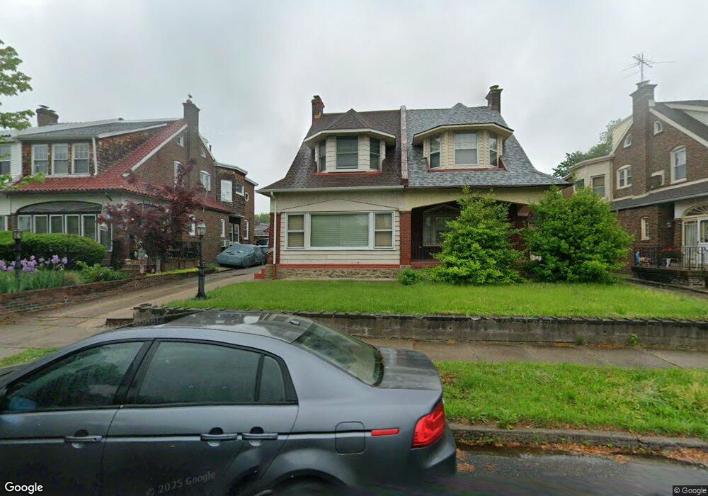
1069 Granite St Philadelphia, PA 19124
Frankford NeighborhoodEstimated Value: $293,088 - $352,000
4
Beds
1
Bath
1,980
Sq Ft
$160/Sq Ft
Est. Value
About This Home
This home is located at 1069 Granite St, Philadelphia, PA 19124 and is currently estimated at $317,772, approximately $160 per square foot. 1069 Granite St is a home located in Philadelphia County with nearby schools including Frankford High School, The Philadelphia Charter School for the Arts & Sciences, and Northwood Academy Charter School.
Ownership History
Date
Name
Owned For
Owner Type
Purchase Details
Closed on
Oct 27, 1999
Sold by
Carretta Maria F and Lennon Maria F
Bought by
Mclain Leonard J and Mclain Beverly C
Current Estimated Value
Home Financials for this Owner
Home Financials are based on the most recent Mortgage that was taken out on this home.
Original Mortgage
$96,900
Interest Rate
7.79%
Purchase Details
Closed on
Jan 19, 1996
Sold by
Clausen Ruth V
Bought by
Carretta Maria F
Create a Home Valuation Report for This Property
The Home Valuation Report is an in-depth analysis detailing your home's value as well as a comparison with similar homes in the area
Home Values in the Area
Average Home Value in this Area
Purchase History
| Date | Buyer | Sale Price | Title Company |
|---|---|---|---|
| Mclain Leonard J | $95,000 | -- | |
| Carretta Maria F | $86,750 | -- |
Source: Public Records
Mortgage History
| Date | Status | Borrower | Loan Amount |
|---|---|---|---|
| Previous Owner | Mclain Leonard J | $96,900 |
Source: Public Records
Tax History Compared to Growth
Tax History
| Year | Tax Paid | Tax Assessment Tax Assessment Total Assessment is a certain percentage of the fair market value that is determined by local assessors to be the total taxable value of land and additions on the property. | Land | Improvement |
|---|---|---|---|---|
| 2026 | $3,050 | $268,400 | $53,680 | $214,720 |
| 2025 | $3,050 | $268,400 | $53,680 | $214,720 |
| 2024 | $3,050 | $268,400 | $53,680 | $214,720 |
| 2023 | $3,050 | $217,900 | $43,580 | $174,320 |
| 2022 | $2,385 | $217,900 | $43,580 | $174,320 |
| 2021 | $2,385 | $0 | $0 | $0 |
| 2020 | $2,385 | $0 | $0 | $0 |
| 2019 | $2,289 | $0 | $0 | $0 |
| 2018 | $2,165 | $0 | $0 | $0 |
| 2017 | $2,165 | $0 | $0 | $0 |
| 2016 | $2,149 | $0 | $0 | $0 |
| 2015 | $1,671 | $0 | $0 | $0 |
| 2014 | -- | $154,700 | $42,630 | $112,070 |
| 2012 | -- | $22,784 | $3,245 | $19,539 |
Source: Public Records
Map
Nearby Homes
- 1048 Bridge St
- 1137 Bridge St
- 1204 Pratt St
- 5659 Miriam Rd
- 5661 Miriam Rd
- 1218 Pratt St
- 1220 Pratt St
- 5640 Miriam Rd
- 5347 Sylvester St
- 1244 E Sanger St
- 5505 Loretto Ave
- 5118 Oakland St
- 996 Anchor St
- 991 Carver St
- 1208 Haworth St
- 1431 Rosalie St
- 5304 Akron St
- 1214 Haworth St
- 5241 Akron St
- 1052 Allengrove St
- 1071 Granite St
- 1063 Granite St
- 1061 Granite St
- 1077 Granite St
- 5252 Oxford Ave
- 1079 Granite St
- 1055 Granite St
- 5254 Oxford Ave
- 1053 Granite St
- 5260 Oxford Ave
- 1066 Granite St
- 1083 Granite St
- 0 Oxford Ave
- 1052 Bridge St
- 1060 Granite St
- 1068 Granite St
- 1058 Granite St
- 1074 Granite St
- 1050 Bridge St
- 1052 Granite St