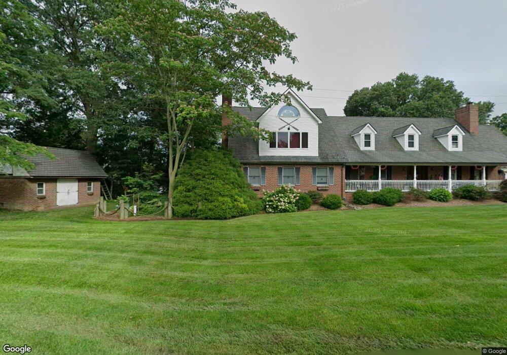
1069 Harding Blvd West River, MD 20778
Estimated Value: $900,000 - $1,265,000
Studio
2
Baths
3,600
Sq Ft
$302/Sq Ft
Est. Value
About This Home
This home is located at 1069 Harding Blvd, West River, MD 20778 and is currently estimated at $1,086,366, approximately $301 per square foot. 1069 Harding Blvd is a home located in Anne Arundel County with nearby schools including Deale Elementary School, Southern Middle School, and Southern High School.
Ownership History
Date
Name
Owned For
Owner Type
Purchase Details
Closed on
Oct 10, 2023
Sold by
Stanley Lee W
Bought by
Stanley Lee W and Stanley Lisa W
Current Estimated Value
Purchase Details
Closed on
Jan 5, 2006
Sold by
Stanley Lee W
Bought by
Hess David C and Genua Steve
Purchase Details
Closed on
Dec 22, 2005
Sold by
Stanley Lee W
Bought by
Hess David C and Genua Steve
Purchase Details
Closed on
Nov 12, 1987
Sold by
Beck Della
Bought by
Stanley Lee W
Create a Home Valuation Report for This Property
The Home Valuation Report is an in-depth analysis detailing your home's value as well as a comparison with similar homes in the area
Home Values in the Area
Average Home Value in this Area
Purchase History
| Date | Buyer | Sale Price | Title Company |
|---|---|---|---|
| Stanley Lee W | -- | None Listed On Document | |
| Hess David C | -- | -- | |
| Hess David C | -- | -- | |
| Stanley Lee W | $85,000 | -- |
Source: Public Records
Tax History
| Year | Tax Paid | Tax Assessment Tax Assessment Total Assessment is a certain percentage of the fair market value that is determined by local assessors to be the total taxable value of land and additions on the property. | Land | Improvement |
|---|---|---|---|---|
| 2025 | $6,863 | $973,400 | -- | -- |
| 2024 | $6,863 | $932,200 | $0 | $0 |
| 2023 | $6,668 | $891,000 | $575,300 | $315,700 |
| 2022 | $6,272 | $885,267 | $0 | $0 |
| 2020 | $6,033 | $873,800 | $575,300 | $298,500 |
| 2019 | $5,878 | $813,033 | $0 | $0 |
| 2018 | $7,628 | $752,267 | $0 | $0 |
| 2017 | $5,428 | $691,500 | $0 | $0 |
| 2016 | $325 | $659,467 | $0 | $0 |
| 2015 | $325 | $627,433 | $0 | $0 |
| 2014 | -- | $595,400 | $0 | $0 |
Source: Public Records
Map
Nearby Homes
- 1006 Henry Ave
- 4907 Quince St
- 4951 Dogwood St
- 1209 Johnson Dr
- 4908 Olive St
- 1161 Steamboat Rd
- 4908 Aspen St
- 1205 Avalon Blvd
- 1330 Jordan Dr
- 1225 Juniper St
- 1241 Steamboat Rd
- 1222 Juniper St
- 1237A Juniper St
- 5115 Holly Dr
- 0 Riverside Dr Unit BOATSLIP C21
- 5235 Chalk Point Rd
- 819 Elm Dr
- 6512 Shady Side Rd
- 6508 Shady Side Rd
- 1419 Shady Rest Rd
- 1020 Harding Blvd
- 1028 Harding Blvd
- 1065 Harding Blvd
- 1031 Back Bay Beach Rd
- 1029 Back Bay Beach Rd
- 1027 Back Bay Beach Rd
- 1028 Dunnington Place
- 1057 Harding Blvd
- 1035 Back Bay Beach Rd
- 1106 Cherry Point Rd
- 1025 Back Bay Beach Rd
- 1055 Harding Blvd
- 1053 Harding Blvd
- 1024 Dunnington Place
- 0 Harding Blvd
- 1037 Back Bay Beach Rd
- 2 Cherry Ln
- 1021 Back Bay Beach Rd
- 1022 Dunnington Place
- 1104 Cherry Point Rd
Your Personal Tour Guide
Ask me questions while you tour the home.