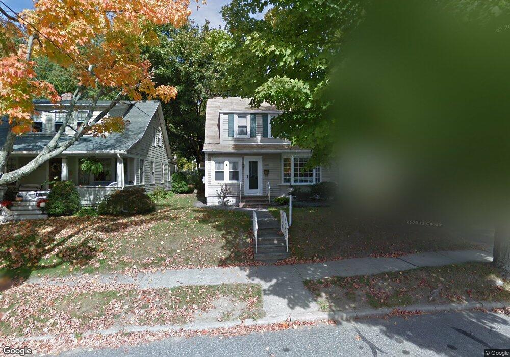
1069 Pine St Palmer, MA 01069
Estimated Value: $278,916 - $401,000
3
Beds
2
Baths
1,472
Sq Ft
$212/Sq Ft
Est. Value
About This Home
This home is located at 1069 Pine St, Palmer, MA 01069 and is currently estimated at $312,229, approximately $212 per square foot. 1069 Pine St is a home located in Hampden County with nearby schools including Old Mill Pond Elementary School, Converse Middle School, and Palmer High School.
Ownership History
Date
Name
Owned For
Owner Type
Purchase Details
Closed on
Nov 29, 1993
Sold by
Holden Roger P and Holden Carol S
Bought by
Perry David R and Perry Kimberly A
Current Estimated Value
Home Financials for this Owner
Home Financials are based on the most recent Mortgage that was taken out on this home.
Original Mortgage
$103,500
Interest Rate
6.72%
Mortgage Type
Purchase Money Mortgage
Create a Home Valuation Report for This Property
The Home Valuation Report is an in-depth analysis detailing your home's value as well as a comparison with similar homes in the area
Home Values in the Area
Average Home Value in this Area
Purchase History
| Date | Buyer | Sale Price | Title Company |
|---|---|---|---|
| Perry David R | $112,000 | -- | |
| Perry David R | $112,000 | -- |
Source: Public Records
Mortgage History
| Date | Status | Borrower | Loan Amount |
|---|---|---|---|
| Open | Perry David R | $108,500 | |
| Closed | Perry David R | $16,000 | |
| Closed | Perry David R | $103,500 |
Source: Public Records
Tax History
| Year | Tax Paid | Tax Assessment Tax Assessment Total Assessment is a certain percentage of the fair market value that is determined by local assessors to be the total taxable value of land and additions on the property. | Land | Improvement |
|---|---|---|---|---|
| 2025 | $3,465 | $190,900 | $50,700 | $140,200 |
| 2024 | $3,221 | $172,500 | $46,100 | $126,400 |
| 2023 | $3,134 | $161,200 | $46,100 | $115,100 |
| 2022 | $3,129 | $146,200 | $40,400 | $105,800 |
| 2021 | $2,171 | $129,100 | $44,800 | $84,300 |
| 2020 | $2,841 | $124,600 | $44,800 | $79,800 |
| 2019 | $2,759 | $124,600 | $44,800 | $79,800 |
| 2018 | $2,674 | $121,100 | $43,500 | $77,600 |
| 2017 | $2,612 | $121,100 | $43,500 | $77,600 |
| 2016 | $2,506 | $117,800 | $42,300 | $75,500 |
| 2015 | -- | $117,800 | $42,300 | $75,500 |
Source: Public Records
Map
Nearby Homes
- 62-91 Lawrence St
- Lots 39-42 Lawrence
- 0 St Unit 73414881
- 7,37,38 Thorndike and Lawrence St
- 1682 N Main St
- 405 Shearer St
- 1242 S Main St
- 1240 S Main St
- Lot 8 Breckenridge St
- 15 Quaboag Valley Co-Op St Unit 15
- 54-57 Breton and Calkins Rd
- 22 Pine View
- 0 Hovey Rd
- 2136 Baptist Hill Rd
- 101 Ware St
- 0 Old Warren Rd
- 268 Palmer Rd Unit 27
- 268 Palmer Rd Unit 2
- L16 Wilbraham St
- 69 E Palmer Park Dr
- 1067 Pine St
- 1071 Pine St
- 0 Buckland St Unit 71427132
- 0 Buckland St Unit 71645719
- 0 Buckland St Unit 71858850
- 1073 Pine St
- 1065 Pine St
- 1070 Pine St
- 10 Buckland St
- 30 Spring St
- 2 Brown St
- 5 Brown St
- 1077 Pine St
- 1064 Pine St
- 1061 A+B Pine St
- 1061 Pine St
- 1038 Spring St
- 6 Brown St
- 11 Brown St
- 1034 Spring St
Your Personal Tour Guide
Ask me questions while you tour the home.