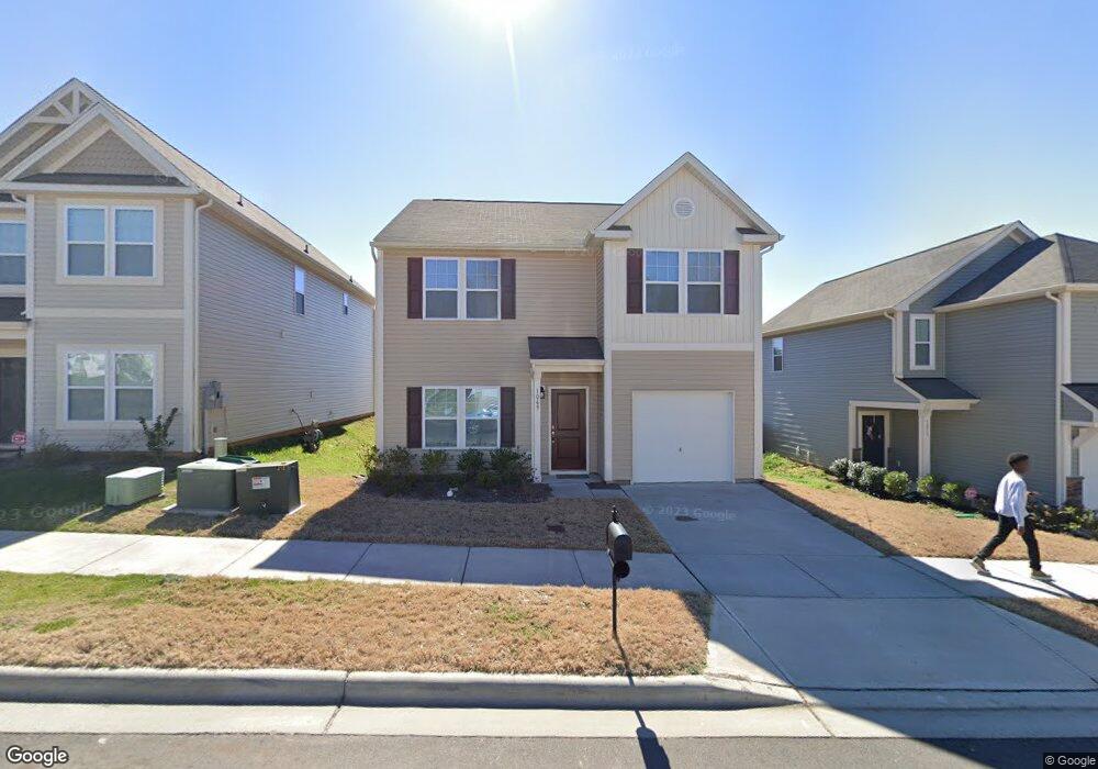
1069 Ramsgate Dr SW Concord, NC 28025
Estimated Value: $324,642 - $360,000
3
Beds
3
Baths
2,200
Sq Ft
$155/Sq Ft
Est. Value
About This Home
This home is located at 1069 Ramsgate Dr SW, Concord, NC 28025 and is currently estimated at $341,411, approximately $155 per square foot. 1069 Ramsgate Dr SW is a home located in Cabarrus County with nearby schools including A.T. Allen Elementary School, C.C. Griffin Middle School, and Central Cabarrus High School.
Ownership History
Date
Name
Owned For
Owner Type
Purchase Details
Closed on
Nov 5, 2019
Sold by
Opendoor Properties J Llc
Bought by
Progress Charlotte Llc
Current Estimated Value
Purchase Details
Closed on
Oct 25, 2019
Sold by
Woods Michael W and Woods Nicole Sheri
Bought by
Opendoor Property J Llc
Purchase Details
Closed on
Jun 28, 2017
Sold by
True Homes Llc
Bought by
Woods Michael W
Home Financials for this Owner
Home Financials are based on the most recent Mortgage that was taken out on this home.
Original Mortgage
$153,238
Interest Rate
4.02%
Mortgage Type
New Conventional
Purchase Details
Closed on
Jan 27, 2017
Sold by
Dependable Development Inc
Bought by
True Homes Llc
Create a Home Valuation Report for This Property
The Home Valuation Report is an in-depth analysis detailing your home's value as well as a comparison with similar homes in the area
Home Values in the Area
Average Home Value in this Area
Purchase History
| Date | Buyer | Sale Price | Title Company |
|---|---|---|---|
| Progress Charlotte Llc | $204,000 | None Available | |
| Opendoor Property J Llc | $200,500 | None Available | |
| Woods Michael W | $170,500 | None Available | |
| True Homes Llc | $85,500 | None Available |
Source: Public Records
Mortgage History
| Date | Status | Borrower | Loan Amount |
|---|---|---|---|
| Previous Owner | Woods Michael W | $153,238 |
Source: Public Records
Tax History
| Year | Tax Paid | Tax Assessment Tax Assessment Total Assessment is a certain percentage of the fair market value that is determined by local assessors to be the total taxable value of land and additions on the property. | Land | Improvement |
|---|---|---|---|---|
| 2025 | $3,256 | $326,900 | $68,000 | $258,900 |
| 2024 | $3,256 | $326,900 | $68,000 | $258,900 |
| 2023 | $2,605 | $213,520 | $40,000 | $173,520 |
| 2022 | $2,605 | $213,520 | $40,000 | $173,520 |
| 2021 | $2,605 | $213,520 | $40,000 | $173,520 |
| 2020 | $2,605 | $213,520 | $40,000 | $173,520 |
| 2019 | $1,982 | $162,450 | $20,000 | $142,450 |
| 2018 | $1,949 | $162,450 | $20,000 | $142,450 |
| 2017 | $236 | $20,000 | $20,000 | $0 |
Source: Public Records
Map
Nearby Homes
- 4175 Broadstairs Dr
- 1039 Manston Place SW
- 4194 Clifftonville Ave SW
- 836 Chastain Ave
- 608 Nannyberry Ln
- 741 Nannyberry Ln
- 4003 Long Arrow Dr Unit 366
- 4018 Bethesda Place
- 685 Continental Dr
- 1009 Braxton Dr
- 1308 Roseberry Place SW
- 1234 Piney Church Rd
- 3560 Us Highway 601 S
- 4227 Kiser Woods Dr SW
- 5248 Ellie Ct
- 1562 Piney Church Rd
- 4274 Kiser Woods Dr SW
- 123 Softwind Ln
- 3044 Parade Ln SW
- 5582 Flowes Store Rd
- 1073 Ramsgate Dr SW Unit 69
- 1065 Ramsgate Dr SW
- 1061 Ramsgate Dr SW
- 1077 Ramsgate Dr SW
- 1081 Ramsgate Dr SW
- 1068 Ramsgate Dr SW
- 1057 Ramsgate Dr SW
- 1072 Ramsgate Dr SW
- 1064 Ramsgate Dr SW
- 1053 Ramsgate Dr SW
- 4192 Pegwell Ave
- 1076 Ramsgate Dr SW
- 4816 Broadstairs Dr SW
- 1080 Ramsgate Dr SW Unit 180
- 4186 Pegwell Ave
- 4222 Broadstairs Dr
- 1056 Ramsgate Dr SW
- 1083 Manston Place SW
- 1083 Manston Place SW Unit 60
- 4182 Pegwell Ave
Your Personal Tour Guide
Ask me questions while you tour the home.