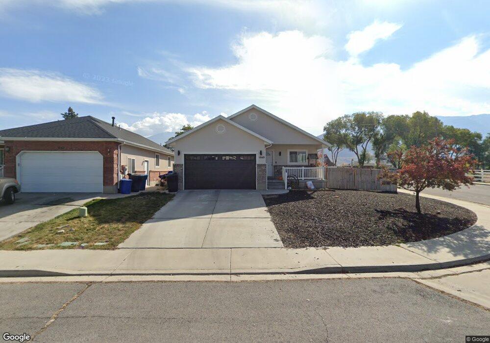
1069 S 530 W Payson, UT 84651
Estimated Value: $496,000 - $511,383
5
Beds
3
Baths
2,864
Sq Ft
$176/Sq Ft
Est. Value
About This Home
This home is located at 1069 S 530 W, Payson, UT 84651 and is currently estimated at $504,461, approximately $176 per square foot. 1069 S 530 W is a home located in Utah County with nearby schools including Wilson Elementary School, Payson Junior High School, and Payson High School.
Ownership History
Date
Name
Owned For
Owner Type
Purchase Details
Closed on
Jul 20, 2017
Sold by
Hjorth Jeffrey A
Bought by
Hjorth Jeffrey A and Hjorth Tristen S
Current Estimated Value
Home Financials for this Owner
Home Financials are based on the most recent Mortgage that was taken out on this home.
Original Mortgage
$203,500
Outstanding Balance
$169,074
Interest Rate
3.89%
Mortgage Type
New Conventional
Estimated Equity
$335,387
Purchase Details
Closed on
Jan 7, 1999
Sold by
Ray Zeeman Construction Inc
Bought by
Floyd Gary and Floyd Carol A
Create a Home Valuation Report for This Property
The Home Valuation Report is an in-depth analysis detailing your home's value as well as a comparison with similar homes in the area
Home Values in the Area
Average Home Value in this Area
Purchase History
| Date | Buyer | Sale Price | Title Company |
|---|---|---|---|
| Hjorth Jeffrey A | -- | First Title Ins Agency | |
| Hjorth Jeffrey A | -- | Us Title Insurance Agency | |
| Floyd Gary | -- | First American Title Co | |
| Ray Zeeman Construction Inc | -- | First American Title Co |
Source: Public Records
Mortgage History
| Date | Status | Borrower | Loan Amount |
|---|---|---|---|
| Open | Hjorth Jeffrey A | $203,500 |
Source: Public Records
Tax History
| Year | Tax Paid | Tax Assessment Tax Assessment Total Assessment is a certain percentage of the fair market value that is determined by local assessors to be the total taxable value of land and additions on the property. | Land | Improvement |
|---|---|---|---|---|
| 2025 | $2,382 | $256,245 | -- | -- |
| 2024 | $2,382 | $242,440 | $0 | $0 |
| 2023 | $2,398 | $244,750 | $0 | $0 |
| 2022 | $2,417 | $242,550 | $0 | $0 |
| 2021 | $2,040 | $328,400 | $93,700 | $234,700 |
| 2020 | $1,913 | $301,300 | $81,500 | $219,800 |
| 2019 | $1,803 | $291,200 | $81,500 | $209,700 |
| 2018 | $1,653 | $257,300 | $63,200 | $194,100 |
| 2017 | $1,415 | $118,415 | $0 | $0 |
| 2016 | $1,372 | $114,070 | $0 | $0 |
| 2015 | $1,294 | $106,865 | $0 | $0 |
| 2014 | $1,167 | $97,075 | $0 | $0 |
Source: Public Records
Map
Nearby Homes
- 1172 S 880 W
- 991 S 930 W
- 846 S 880 W
- 802 Brookside Ct
- 1320 S 950 W
- 1463 S 260 W
- 582 E 1250 S Unit 137
- 626 S 800 W Unit 32
- 1333 S 1050 W
- 1128 W 1150 S Unit 9
- 533 S 700 W
- 1116 W 1290 S
- 1468 S 910 W
- 1338 S 1050 W
- 1152 W 1000 S
- 1146 W 1260 S
- 288 E 900 S
- 1068 S 1150 W
- 876 Greenridge Ave
- 1216 S 1150 W Unit 19
Your Personal Tour Guide
Ask me questions while you tour the home.