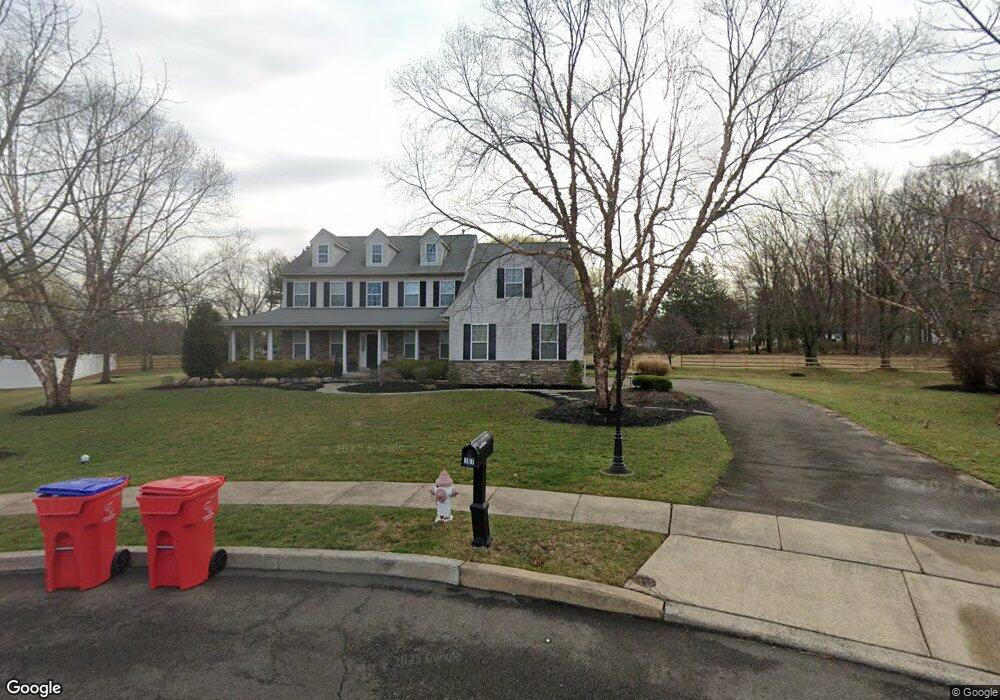
107 Ajas Way Warminster, PA 18974
Estimated Value: $739,000 - $913,000
4
Beds
3
Baths
3,901
Sq Ft
$219/Sq Ft
Est. Value
About This Home
This home is located at 107 Ajas Way, Warminster, PA 18974 and is currently estimated at $852,827, approximately $218 per square foot. 107 Ajas Way is a home located in Bucks County with nearby schools including McDonald Elementary School, Log College Middle School, and William Tennent High School.
Ownership History
Date
Name
Owned For
Owner Type
Purchase Details
Closed on
May 29, 2014
Sold by
Weiskopf Joshua J and Kelly Leanne M
Bought by
Kelly Leanne M
Current Estimated Value
Home Financials for this Owner
Home Financials are based on the most recent Mortgage that was taken out on this home.
Original Mortgage
$355,000
Outstanding Balance
$269,206
Interest Rate
4.12%
Mortgage Type
New Conventional
Estimated Equity
$583,621
Purchase Details
Closed on
Mar 31, 2006
Sold by
D Larosa Builders Inc
Bought by
Weiskopf Joshua J and Kelly Leanne M
Home Financials for this Owner
Home Financials are based on the most recent Mortgage that was taken out on this home.
Original Mortgage
$395,000
Interest Rate
6.26%
Mortgage Type
Purchase Money Mortgage
Create a Home Valuation Report for This Property
The Home Valuation Report is an in-depth analysis detailing your home's value as well as a comparison with similar homes in the area
Home Values in the Area
Average Home Value in this Area
Purchase History
| Date | Buyer | Sale Price | Title Company |
|---|---|---|---|
| Kelly Leanne M | -- | Elite Title & Escrow | |
| Weiskopf Joshua J | $598,130 | None Available |
Source: Public Records
Mortgage History
| Date | Status | Borrower | Loan Amount |
|---|---|---|---|
| Open | Kelly Leanne M | $355,000 | |
| Closed | Weiskopf Joshua J | $395,000 |
Source: Public Records
Tax History Compared to Growth
Tax History
| Year | Tax Paid | Tax Assessment Tax Assessment Total Assessment is a certain percentage of the fair market value that is determined by local assessors to be the total taxable value of land and additions on the property. | Land | Improvement |
|---|---|---|---|---|
| 2025 | $12,744 | $60,380 | $9,020 | $51,360 |
| 2024 | $12,744 | $60,380 | $9,020 | $51,360 |
| 2023 | $12,352 | $60,380 | $9,020 | $51,360 |
| 2022 | $12,088 | $60,380 | $9,020 | $51,360 |
| 2021 | $11,806 | $60,380 | $9,020 | $51,360 |
| 2020 | $11,640 | $60,380 | $9,020 | $51,360 |
| 2019 | $11,022 | $60,380 | $9,020 | $51,360 |
| 2018 | $10,759 | $60,380 | $9,020 | $51,360 |
| 2017 | $10,443 | $60,380 | $9,020 | $51,360 |
| 2016 | $10,443 | $60,380 | $9,020 | $51,360 |
| 2015 | $9,993 | $60,380 | $9,020 | $51,360 |
| 2014 | $9,993 | $60,380 | $9,020 | $51,360 |
Source: Public Records
Map
Nearby Homes
- 11 Lincoln Ave
- 56 Parry Way
- 55 Parry Way
- 59 Parry Way
- The Addis Plan at The Reserve at Spring Mill
- The Beckett Plan at The Reserve at Spring Mill
- 10 Spring Mill Dr
- 11 Spring Mill Dr
- 9 Spring Mill Dr
- 146 Grandview Dr
- 8 Lacey Ln
- 18 Lacey Ln
- 109 Wilson Ave
- 1297 Twin Streams Dr
- 451 Twin Streams Dr
- 667 Arbor Ln
- 290 Hatboro Rd
- 675 Cheryl Dr
- 1070 Decker Ln
- 130 E Street Rd