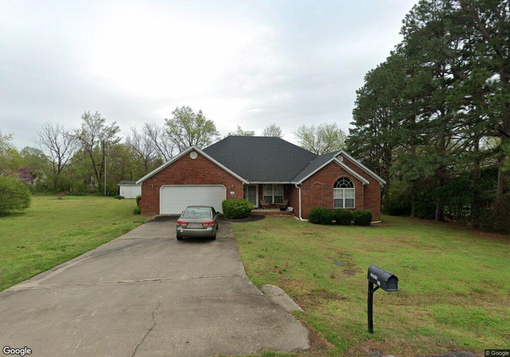
107 Angus Dr Prairie Grove, AR 72753
Estimated Value: $374,000 - $436,000
3
Beds
3
Baths
2,325
Sq Ft
$174/Sq Ft
Est. Value
About This Home
This home is located at 107 Angus Dr, Prairie Grove, AR 72753 and is currently estimated at $405,313, approximately $174 per square foot. 107 Angus Dr is a home located in Washington County with nearby schools including Prairie Grove Elementary School, Prairie Grove Middle School, and Prairie Grove Junior High School.
Ownership History
Date
Name
Owned For
Owner Type
Purchase Details
Closed on
Nov 28, 2005
Sold by
Caudle Maxine F
Bought by
Moulden Janet
Current Estimated Value
Purchase Details
Closed on
Jul 12, 2005
Sold by
Caudle Maxine F
Bought by
Caudle Maxine and Maxine F Caudle Revocable Trust
Purchase Details
Closed on
Mar 5, 1998
Bought by
Caudle James and Caudle Maxine F
Purchase Details
Closed on
Sep 19, 1997
Bought by
Fritts Thomas and Lavania Ann
Purchase Details
Closed on
Apr 10, 1997
Bought by
Fritts Lavania Annv and Fritts Kinion,
Purchase Details
Closed on
Nov 1, 1968
Bought by
Yates Howard P and Billie Lou
Create a Home Valuation Report for This Property
The Home Valuation Report is an in-depth analysis detailing your home's value as well as a comparison with similar homes in the area
Home Values in the Area
Average Home Value in this Area
Purchase History
| Date | Buyer | Sale Price | Title Company |
|---|---|---|---|
| Moulden Janet | -- | -- | |
| Caudle Maxine | -- | -- | |
| Caudle James | $141,000 | -- | |
| Fritts Thomas | -- | -- | |
| Fritts Lavania Annv | $16,000 | -- | |
| Yates Howard P | -- | -- |
Source: Public Records
Tax History Compared to Growth
Tax History
| Year | Tax Paid | Tax Assessment Tax Assessment Total Assessment is a certain percentage of the fair market value that is determined by local assessors to be the total taxable value of land and additions on the property. | Land | Improvement |
|---|---|---|---|---|
| 2025 | $827 | $70,190 | $8,000 | $62,190 |
| 2024 | $949 | $70,190 | $8,000 | $62,190 |
| 2023 | $1,080 | $70,190 | $8,000 | $62,190 |
| 2022 | $1,130 | $50,840 | $4,900 | $45,940 |
| 2021 | $1,130 | $50,840 | $4,900 | $45,940 |
| 2020 | $1,124 | $50,840 | $4,900 | $45,940 |
| 2019 | $1,141 | $33,090 | $4,000 | $29,090 |
| 2018 | $1,166 | $33,090 | $4,000 | $29,090 |
| 2017 | $1,152 | $33,090 | $4,000 | $29,090 |
| 2016 | $1,152 | $33,090 | $4,000 | $29,090 |
| 2015 | $1,434 | $33,090 | $4,000 | $29,090 |
| 2014 | $1,526 | $34,810 | $4,000 | $30,810 |
Source: Public Records
Map
Nearby Homes
- 608 Catlett St
- 505 Shady Acres Ln
- 710 Marcella St
- Lot 2 Holmes St
- 0 Douglas St Unit 1293623
- TBD Kate Smith St
- 201 E Douglas St
- 303 E Center St
- 106 Jenkins Rd
- 216 Jenkins Rd
- 208 N Neal St
- 4.66 +/- AC Tract 5 Hwy 62 & S Mock St
- 680 Marcella St
- 807 Maple St
- 204 Armstrong St
- 111 W Cleveland St
- 812 Cedar Ln
- 201 E Cleveland St
- 640 Marcella St
- 640 Kendra St