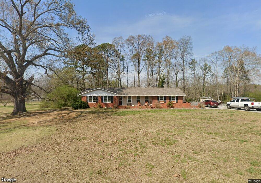
107 Burton Dr Rockmart, GA 30153
Estimated Value: $205,000 - $272,000
3
Beds
2
Baths
1,907
Sq Ft
$131/Sq Ft
Est. Value
About This Home
This home is located at 107 Burton Dr, Rockmart, GA 30153 and is currently estimated at $249,057, approximately $130 per square foot. 107 Burton Dr is a home with nearby schools including Rockmart Middle School.
Ownership History
Date
Name
Owned For
Owner Type
Purchase Details
Closed on
Jun 22, 2016
Sold by
Teresa
Bought by
Gentry Alvin and Gentry Sherry
Current Estimated Value
Purchase Details
Closed on
Jun 12, 2015
Sold by
Dunn Whit
Bought by
Dunn Whit and Dunn Freddy
Purchase Details
Closed on
Jul 23, 2012
Sold by
Baker Teresa and Baker Freddy Dunn
Bought by
Dunn Whit and Dunn Jeanna Gay
Purchase Details
Closed on
May 25, 2006
Sold by
Not Provided
Bought by
Gay Baker Teresa and Gay Baker Jeanne
Purchase Details
Closed on
Jun 14, 1990
Sold by
Spain Willard A
Bought by
Dunn Louise W
Purchase Details
Closed on
Mar 12, 1970
Sold by
Blankenship Charles
Bought by
Spain Fannie Moore W
Purchase Details
Closed on
Mar 28, 1966
Bought by
Blankenship Charles
Create a Home Valuation Report for This Property
The Home Valuation Report is an in-depth analysis detailing your home's value as well as a comparison with similar homes in the area
Home Values in the Area
Average Home Value in this Area
Purchase History
| Date | Buyer | Sale Price | Title Company |
|---|---|---|---|
| Gentry Alvin | $75,000 | -- | |
| Dunn Whit | -- | -- | |
| Dunn Whit | -- | -- | |
| Gay Baker Teresa | -- | -- | |
| Gay Baker Teresa | -- | -- | |
| Dunn Louise W | -- | -- | |
| Spain Fannie Moore W | -- | -- | |
| Blankenship Charles | -- | -- |
Source: Public Records
Tax History Compared to Growth
Tax History
| Year | Tax Paid | Tax Assessment Tax Assessment Total Assessment is a certain percentage of the fair market value that is determined by local assessors to be the total taxable value of land and additions on the property. | Land | Improvement |
|---|---|---|---|---|
| 2024 | $1,924 | $94,026 | $8,000 | $86,026 |
| 2023 | $1,372 | $59,808 | $8,000 | $51,808 |
| 2022 | $1,077 | $47,367 | $8,000 | $39,367 |
| 2021 | $1,139 | $47,367 | $8,000 | $39,367 |
| 2020 | $1,141 | $47,367 | $8,000 | $39,367 |
| 2019 | $902 | $33,575 | $6,000 | $27,575 |
| 2018 | $902 | $32,717 | $6,000 | $26,717 |
| 2017 | $816 | $32,717 | $6,000 | $26,717 |
| 2016 | $890 | $32,717 | $6,000 | $26,717 |
| 2015 | $897 | $32,878 | $6,000 | $26,878 |
| 2014 | $892 | $32,461 | $5,583 | $26,878 |
| 2013 | -- | $30,786 | $3,886 | $26,900 |
Source: Public Records
Map
Nearby Homes
- 18 Hillside Dr
- 184 Morgan Ln
- 865 Morgan Valley Rd
- 155 Government Farm Rd
- 107 Main Line Rd
- 332 Stringer Rd
- 11 Lee St
- 92 Autumn Path
- 1714 Cedartown Hwy
- 0 Pine Mountain St Unit 10620510
- 0 Pine Mountain St Unit 10620492
- 318 Morgan Valley Rd
- 1039 Old Cedartown Rd
- 831 Government Farm Rd
- 1 Pine Mountain Rd
- 780 Government Farm Rd
- 93 Clay Rd
- 847 Polk St
- 740 Calloway Dr
- 1825 Calloway Path