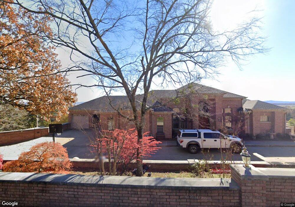
107 Cedarcrest Dr Morrilton, AR 72110
Estimated Value: $373,000 - $725,351
Studio
4
Baths
5,161
Sq Ft
$106/Sq Ft
Est. Value
About This Home
This home is located at 107 Cedarcrest Dr, Morrilton, AR 72110 and is currently estimated at $549,176, approximately $106 per square foot. 107 Cedarcrest Dr is a home located in Conway County with nearby schools including Morrilton Primary School, Morrilton Elementary School, and Morrilton Intermediate School.
Ownership History
Date
Name
Owned For
Owner Type
Purchase Details
Closed on
Apr 26, 2022
Sold by
Koontz Benny M and Koontz Paula K
Bought by
Koontz Land Management Llc
Current Estimated Value
Purchase Details
Closed on
Jan 27, 2022
Sold by
Koontz Property Management Llc
Bought by
Koontz Benny and Koontz Paula
Purchase Details
Closed on
Sep 4, 1997
Bought by
Koontz Benny and Koontz Paula
Purchase Details
Closed on
Jun 11, 1996
Bought by
Koontz Kenneth
Purchase Details
Closed on
Jan 1, 1984
Bought by
K & K Enterprises
Create a Home Valuation Report for This Property
The Home Valuation Report is an in-depth analysis detailing your home's value as well as a comparison with similar homes in the area
Home Values in the Area
Average Home Value in this Area
Purchase History
| Date | Buyer | Sale Price | Title Company |
|---|---|---|---|
| Koontz Land Management Llc | -- | Hyden Miron & Foster Pllc | |
| Koontz Benny | -- | None Listed On Document | |
| Koontz Electric Company | -- | None Listed On Document | |
| Koontz Benny | -- | -- | |
| Koontz Kenneth | -- | -- | |
| K & K Enterprises | -- | -- |
Source: Public Records
Mortgage History
| Date | Status | Borrower | Loan Amount |
|---|---|---|---|
| Previous Owner | K & K Enterprises | $0 |
Source: Public Records
Tax History Compared to Growth
Tax History
| Year | Tax Paid | Tax Assessment Tax Assessment Total Assessment is a certain percentage of the fair market value that is determined by local assessors to be the total taxable value of land and additions on the property. | Land | Improvement |
|---|---|---|---|---|
| 2025 | $6,413 | $129,630 | $11,230 | $118,400 |
| 2024 | $6,323 | $129,630 | $11,230 | $118,400 |
| 2023 | $6,101 | $129,630 | $11,230 | $118,400 |
| 2022 | $5,855 | $129,630 | $11,230 | $118,400 |
| 2021 | $5,561 | $109,720 | $10,170 | $99,550 |
| 2020 | $5,561 | $109,720 | $10,170 | $99,550 |
| 2019 | $5,478 | $108,180 | $10,170 | $98,010 |
| 2018 | $5,476 | $108,180 | $10,170 | $98,010 |
| 2017 | $5,211 | $108,180 | $10,170 | $98,010 |
| 2016 | $4,877 | $99,160 | $10,140 | $89,020 |
| 2015 | $4,558 | $99,160 | $10,140 | $89,020 |
| 2014 | $4,165 | $95,060 | $10,140 | $84,920 |
Source: Public Records
Map
Nearby Homes
- 00 Winthrop Dr
- 7 Winthrop Dr
- 4 Deerwood Dr
- 13 Eugenia St
- 108 Northfork Dr
- 601 Green St
- 00 S Burrow St
- 9 W Winthrop Rd
- 00 S Bridge St
- 903 & 905 S Moose St
- 901 & 902 S Moose St
- 311 N Will St
- 303 S Saint Joseph St
- 705 E Commerce St
- 7 Sunset Blvd
- 401 S Moose St
- 1310 Branch St
- 600 Oaklawn Dr
- 411 E Branch
- 1207 E Rock St
- 108 Cedarcrest Dr
- 106 Cedarcrest Dr
- 104 Cedarcrest Dr
- 110 Cedarcrest Dr
- 0 Cedar Crest Dr
- 111 Cedarcrest Dr
- 1 Winthrop Dr
- 0 Winthrop Dr Unit 17002455
- E Winthrop Dr
- 2 E Winthrop Dr
- 102 Cedarcrest Dr
- 3 Winthrop Dr
- 607 S Bridge St
- 502 S Bridge St
- 4 Winthrop Dr
- 508 S Bridge St
- 114 Cedarcrest Dr
- 5 Winthrop Dr
- 115 Cedarcrest Dr
- 1 Stroud Dr