Estimated Value: $242,000 - $322,000
3
Beds
1
Bath
1,180
Sq Ft
$236/Sq Ft
Est. Value
About This Home
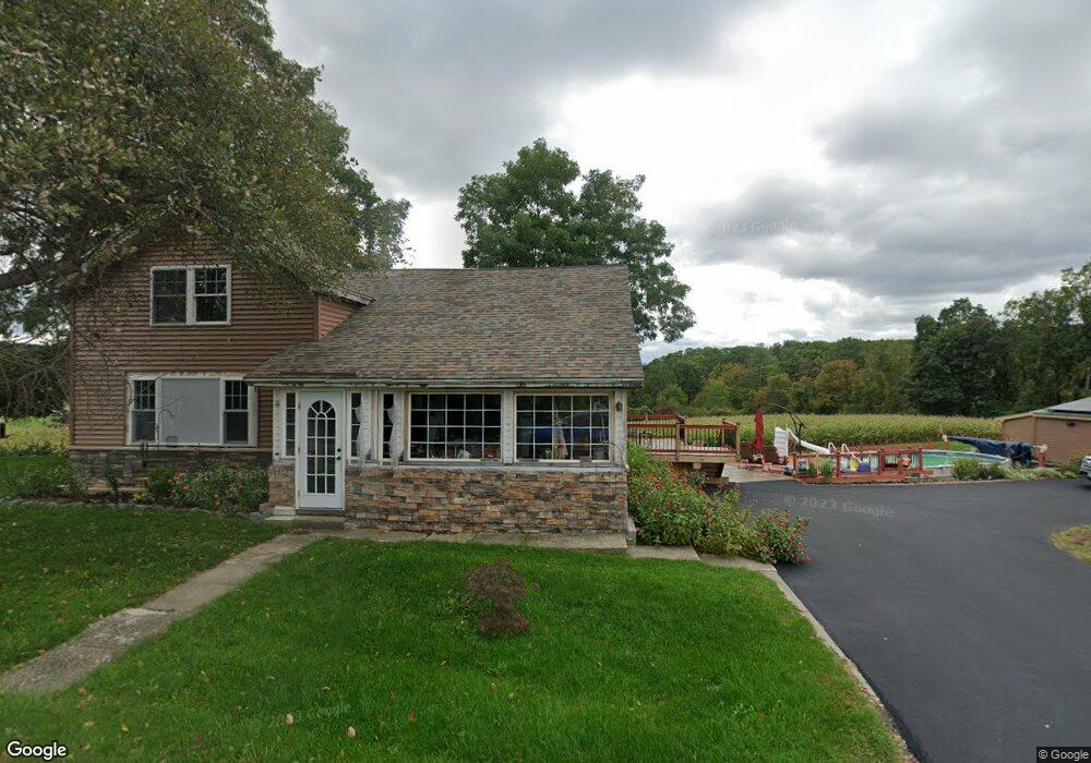
This home is located at 107 Cooksboro Rd, Troy, NY 12182 and is currently estimated at $277,982, approximately $235 per square foot. 107 Cooksboro Rd is a home located in Rensselaer County with nearby schools including Tamarac Elementary School and Tamarac Middle School High School.
Ownership History
Date
Name
Owned For
Owner Type
Purchase Details
Closed on
Oct 22, 2021
Sold by
Hansen Kevin R
Bought by
Earthsafe Prop Grp Llc
Current Estimated Value
Purchase Details
Closed on
Jun 10, 2016
Sold by
Newell Melissa
Bought by
Blair Daniel
Home Financials for this Owner
Home Financials are based on the most recent Mortgage that was taken out on this home.
Original Mortgage
$158,476
Interest Rate
3.75%
Mortgage Type
FHA
Purchase Details
Closed on
Nov 16, 2009
Sold by
Read Georgia H
Bought by
Holt Melissa J
Purchase Details
Closed on
Nov 20, 1996
Create a Home Valuation Report for This Property
The Home Valuation Report is an in-depth analysis detailing your home's value as well as a comparison with similar homes in the area
Home Values in the Area
Average Home Value in this Area
Purchase History
| Date | Buyer | Sale Price | Title Company |
|---|---|---|---|
| Earthsafe Prop Grp Llc | $170,000 | None Available | |
| Earthsafe Prop Grp Llc | $170,000 | None Available | |
| Earthsafe Prop Grp Llc | $170,000 | None Available | |
| Blair Daniel | $161,400 | Rodney C. Powis | |
| Blair Daniel | $161,400 | Rodney C. Powis | |
| Holt Melissa J | $137,000 | Thomas D Spain | |
| Holt Melissa J | $137,000 | Thomas D Spain | |
| -- | -- | -- | |
| -- | -- | -- |
Source: Public Records
Mortgage History
| Date | Status | Borrower | Loan Amount |
|---|---|---|---|
| Previous Owner | Blair Daniel | $158,476 |
Source: Public Records
Tax History Compared to Growth
Tax History
| Year | Tax Paid | Tax Assessment Tax Assessment Total Assessment is a certain percentage of the fair market value that is determined by local assessors to be the total taxable value of land and additions on the property. | Land | Improvement |
|---|---|---|---|---|
| 2024 | $5,291 | $210,000 | $30,000 | $180,000 |
| 2023 | $4,505 | $77,800 | $2,200 | $75,600 |
| 2022 | $4,382 | $77,800 | $2,200 | $75,600 |
| 2021 | $4,284 | $77,800 | $2,200 | $75,600 |
| 2020 | $4,212 | $77,800 | $2,200 | $75,600 |
| 2019 | $4,062 | $77,800 | $2,200 | $75,600 |
| 2018 | $4,062 | $77,800 | $2,200 | $75,600 |
| 2017 | $4,356 | $77,800 | $2,200 | $75,600 |
| 2016 | $4,246 | $77,800 | $2,200 | $75,600 |
| 2015 | -- | $77,800 | $2,200 | $75,600 |
| 2014 | -- | $77,800 | $2,200 | $75,600 |
Source: Public Records
Map
Nearby Homes
- 71 Cooksboro Rd
- 1789 New York 7
- 65 Deepkill Rd
- 34 Ford Rd
- 87 Le Loup Rd
- 17 Johnny Cake Hollow Rd
- 214 N Pole Rd
- 2 Ribbon Candy Ln
- 13 Ribbon Candy Ln
- 1346 State Highway 7
- 13 Camel Hill Rd
- 343 Sweetmilk Creek Rd
- 274 Bald Mountain Rd
- 1232 State Highway 7
- 87 Bulson Rd
- 85 Stuffle St
- 319 Speigletown Rd
- 10 Springbrook Rd
- 42 Ashcroft Rd
- 233 Keefe Rd
- 97 Cooksboro Rd
- 85 Cooksboro Rd
- 137 Cooksboro Rd
- 138 Cooksboro Rd
- 55 Cooksboro Rd
- 36 Cooksboro Rd
- 1925 State Highway 7
- 1927 New York 7
- 1927 State Highway 7
- 1906 State Highway 7
- 19 Cooksboro Rd
- 1892 State Highway 7
- 1920 State Highway 7
- 1872 State Highway 7
- 1872 New York 7
- 1944 State Highway 7
- 1925 New York 7
- 1950 New York 7
- 1950 State Highway 7
- 1870 State Highway 7