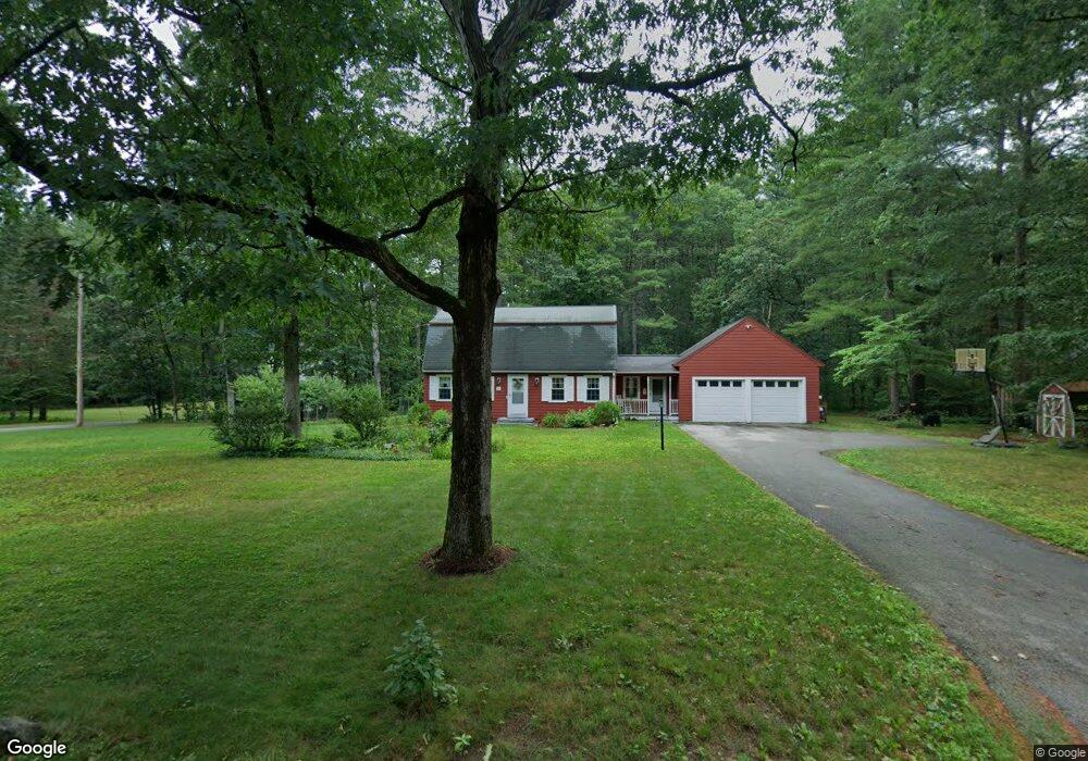
107 Depot St Westford, MA 01886
Estimated Value: $721,454 - $900,000
4
Beds
2
Baths
2,015
Sq Ft
$403/Sq Ft
Est. Value
About This Home
This home is located at 107 Depot St, Westford, MA 01886 and is currently estimated at $812,364, approximately $403 per square foot. 107 Depot St is a home located in Middlesex County with nearby schools including Abbot Elementary School, Nabnasset Elementary, and Stony Brook School.
Ownership History
Date
Name
Owned For
Owner Type
Purchase Details
Closed on
Jul 14, 1997
Sold by
Muir Craig D and Muir Katherine M
Bought by
Marple Stephen and Marple Linda
Current Estimated Value
Purchase Details
Closed on
Jul 8, 1994
Sold by
Rautenberg Norman and Rautenberg Diane
Bought by
Muir Craig D and Muir Katherine
Create a Home Valuation Report for This Property
The Home Valuation Report is an in-depth analysis detailing your home's value as well as a comparison with similar homes in the area
Home Values in the Area
Average Home Value in this Area
Purchase History
| Date | Buyer | Sale Price | Title Company |
|---|---|---|---|
| Marple Stephen | $185,000 | -- | |
| Muir Craig D | $169,900 | -- |
Source: Public Records
Mortgage History
| Date | Status | Borrower | Loan Amount |
|---|---|---|---|
| Open | Muir Craig D | $280,000 | |
| Closed | Muir Craig D | $10,000 | |
| Closed | Muir Craig D | $165,000 |
Source: Public Records
Tax History Compared to Growth
Tax History
| Year | Tax Paid | Tax Assessment Tax Assessment Total Assessment is a certain percentage of the fair market value that is determined by local assessors to be the total taxable value of land and additions on the property. | Land | Improvement |
|---|---|---|---|---|
| 2025 | $8,248 | $612,300 | $350,900 | $261,400 |
| 2024 | $8,029 | $583,100 | $334,200 | $248,900 |
| 2023 | $8,010 | $542,700 | $318,100 | $224,600 |
| 2022 | $7,881 | $488,900 | $271,600 | $217,300 |
| 2021 | $5,730 | $463,200 | $271,600 | $191,600 |
| 2020 | $7,603 | $465,600 | $271,600 | $194,000 |
| 2019 | $7,223 | $436,200 | $255,100 | $181,100 |
| 2018 | $6,851 | $423,400 | $244,000 | $179,400 |
| 2017 | $5,134 | $409,500 | $244,000 | $165,500 |
| 2016 | $6,481 | $397,600 | $230,100 | $167,500 |
| 2015 | $6,491 | $399,700 | $230,100 | $169,600 |
| 2014 | $6,507 | $392,000 | $220,600 | $171,400 |
Source: Public Records
Map
Nearby Homes
- 3 Blue Heron Dr
- 6 Plain Rd
- 16 Shipley Cir
- 6 Lady Constance Way
- 6 Lady Constance Way Unit 21
- Copley Plan at Wendell Place
- Williamstown Plan at Wendell Place
- 2 Lady Constance Way Unit 19
- 4 Lady Constance Way Unit 20
- 5 Fawn Rd
- 2 Wendell Place Unit 1
- 14 Fletcher Rd
- 7 Heywood Rd
- 18 Fletcher Rd
- 239 Groton Rd
- 8 Loon Way
- 9 Loon Way
- 3 Loon Way
- 55 Lawson Rd
- 2 Alder Point Unit 2
- 105 Depot St
- 111 Depot St
- 113 Depot St
- 65 Riley Rd Unit 105
- 34 Riley Rd Unit 36
- 75 Riley Rd Unit 110
- 24 Riley Rd Unit 41
- 36 Riley Rd Unit 35
- 38 Riley Rd Unit 35
- 40 Riley Rd Unit 33
- 38 Riley Rd Unit 34
- 37 Riley Rd Unit 19
- 114 Depot St
- 51 Riley Rd Unit 26
- 43 Riley Rd Unit 22
- 35 Riley Rd Unit 18
- 25 Riley Rd Unit 13
- 31 Riley Rd Unit 16
- 17 Riley Rd Unit 66
- 27 Riley Rd Unit 14