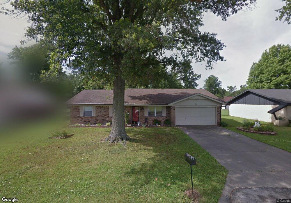
107 E Henson Ave Springdale, AR 72764
Shady Grove NeighborhoodEstimated Value: $295,891 - $328,000
Studio
2
Baths
1,764
Sq Ft
$177/Sq Ft
Est. Value
About This Home
This home is located at 107 E Henson Ave, Springdale, AR 72764 and is currently estimated at $311,973, approximately $176 per square foot. 107 E Henson Ave is a home located in Washington County with nearby schools including J. O. Kelly Middle School, Harp Elementary School, and George Junior High School.
Ownership History
Date
Name
Owned For
Owner Type
Purchase Details
Closed on
Jun 25, 2020
Sold by
Coleman Bobby
Bought by
Coleman Stephanie
Current Estimated Value
Purchase Details
Closed on
Oct 3, 2018
Sold by
Coleman Stephanie and Fleshman Merv
Bought by
Coleman Bobby
Purchase Details
Closed on
Jul 27, 2018
Sold by
Morgan Diane C and Morgan Scott
Bought by
Fleshman Mervin and Fleshman Stephanie
Purchase Details
Closed on
Mar 10, 1986
Bought by
Tolly Mary L
Purchase Details
Closed on
Nov 18, 1980
Bought by
Tolly Ernest M and Tolly Mary L
Create a Home Valuation Report for This Property
The Home Valuation Report is an in-depth analysis detailing your home's value as well as a comparison with similar homes in the area
Home Values in the Area
Average Home Value in this Area
Purchase History
| Date | Buyer | Sale Price | Title Company |
|---|---|---|---|
| Coleman Stephanie | -- | None Available | |
| Coleman Bobby | -- | None Available | |
| Fleshman Mervin | $150,000 | Lenders Title Co | |
| Tolly Mary L | -- | -- | |
| Tolly Ernest M | -- | -- |
Source: Public Records
Tax History
| Year | Tax Paid | Tax Assessment Tax Assessment Total Assessment is a certain percentage of the fair market value that is determined by local assessors to be the total taxable value of land and additions on the property. | Land | Improvement |
|---|---|---|---|---|
| 2025 | $2,043 | $49,440 | $14,000 | $35,440 |
| 2024 | $1,888 | $49,440 | $14,000 | $35,440 |
| 2023 | $1,767 | $49,440 | $14,000 | $35,440 |
| 2022 | $1,577 | $29,930 | $10,000 | $19,930 |
| 2021 | $1,577 | $29,930 | $10,000 | $19,930 |
| 2020 | $1,289 | $29,930 | $10,000 | $19,930 |
| 2019 | $1,131 | $21,470 | $6,000 | $15,470 |
| 2018 | $781 | $21,470 | $6,000 | $15,470 |
| 2017 | $771 | $21,470 | $6,000 | $15,470 |
| 2016 | $771 | $21,470 | $6,000 | $15,470 |
| 2015 | $771 | $21,470 | $6,000 | $15,470 |
| 2014 | $969 | $25,270 | $7,000 | $18,270 |
Source: Public Records
Map
Nearby Homes
- 204 E Henson Ave
- 108 Lake Rd
- 4402 Bogey Dr
- 309 Lake Rd
- 405 Indian Trail
- 102 Franjo Ln
- 405 Lake Rd
- 4079 Jessica Ln
- 3951 Prince Philipe St
- 507 E Andrew Ave
- 508 Fairway Cir
- 104 Annie Laurie Ave
- 4007 Dixon
- 412 Oak Manor Cir
- 301 W Edmondson Ave
- 587 Bordeaux Ave
- 0 E Don Tyson Pkwy Unit 1333711
- 307 Terry Ave
- 883 E Don Tyson Pkwy
- 5060 Brewster St
- 201 E Henson Ave
- 105 E Henson Ave
- 203 E Henson Ave
- 103 E Henson Ave
- 106 Ranchwood Dr
- 200 Ranchwood Dr
- 100 Ranchwood Dr
- 202 E Henson Ave
- 205 E Henson Ave
- 101 E Henson Ave
- 207 E Henson Ave
- 204 Ranchwood Dr
- 206 E Henson Ave
- 4315 Alma St
- 107 Ranchwood Dr
- 105 Ranchwood Dr
- 101 W Henson Ave
- 4313 Alma St
- 209 E Henson Ave
- 4502 Croxdale St
Your Personal Tour Guide
Ask me questions while you tour the home.