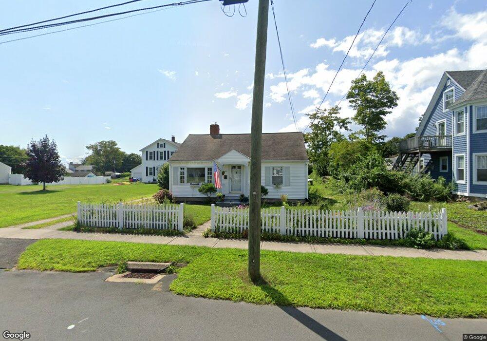
107 Grove St Clinton, CT 06413
Estimated Value: $403,000 - $483,000
2
Beds
1
Bath
858
Sq Ft
$508/Sq Ft
Est. Value
About This Home
This home is located at 107 Grove St, Clinton, CT 06413 and is currently estimated at $436,176, approximately $508 per square foot. 107 Grove St is a home located in Middlesex County with nearby schools including Lewin G. Joel Jr. School, The Morgan School, and Our Lady of Mercy Preparatory Academy.
Ownership History
Date
Name
Owned For
Owner Type
Purchase Details
Closed on
Aug 3, 2009
Sold by
Snelgrove Joy
Bought by
Snelgrove James
Current Estimated Value
Purchase Details
Closed on
Oct 15, 2002
Sold by
Pach Mark C and Pach Heather E
Bought by
Snelgrove James T and Snelgrove Joy
Home Financials for this Owner
Home Financials are based on the most recent Mortgage that was taken out on this home.
Original Mortgage
$156,750
Interest Rate
6.24%
Purchase Details
Closed on
Nov 2, 1998
Sold by
Keiran Margaret R
Bought by
Murray Heather E and Pach Mark C
Create a Home Valuation Report for This Property
The Home Valuation Report is an in-depth analysis detailing your home's value as well as a comparison with similar homes in the area
Home Values in the Area
Average Home Value in this Area
Purchase History
| Date | Buyer | Sale Price | Title Company |
|---|---|---|---|
| Snelgrove James | -- | -- | |
| Snelgrove James | -- | -- | |
| Snelgrove James T | $165,000 | -- | |
| Snelgrove James T | $165,000 | -- | |
| Murray Heather E | $105,000 | -- | |
| Murray Heather E | $105,000 | -- |
Source: Public Records
Mortgage History
| Date | Status | Borrower | Loan Amount |
|---|---|---|---|
| Previous Owner | Murray Heather E | $157,000 | |
| Previous Owner | Murray Heather E | $156,750 |
Source: Public Records
Tax History Compared to Growth
Tax History
| Year | Tax Paid | Tax Assessment Tax Assessment Total Assessment is a certain percentage of the fair market value that is determined by local assessors to be the total taxable value of land and additions on the property. | Land | Improvement |
|---|---|---|---|---|
| 2025 | $4,761 | $152,900 | $80,300 | $72,600 |
| 2024 | $4,627 | $152,900 | $80,300 | $72,600 |
| 2023 | $4,561 | $152,900 | $80,300 | $72,600 |
| 2022 | $4,561 | $152,900 | $80,300 | $72,600 |
| 2021 | $4,889 | $163,900 | $95,300 | $68,600 |
| 2020 | $5,122 | $163,900 | $95,300 | $68,600 |
| 2019 | $5,122 | $163,900 | $95,300 | $68,600 |
| 2018 | $5,006 | $163,900 | $95,300 | $68,600 |
| 2017 | $4,902 | $163,900 | $95,300 | $68,600 |
| 2016 | $4,448 | $163,900 | $95,300 | $68,600 |
| 2015 | $3,860 | $144,200 | $71,000 | $73,200 |
| 2014 | $3,788 | $144,200 | $71,000 | $73,200 |
Source: Public Records
Map
Nearby Homes
- 62 Cedar Island Ave
- 26 Cedar Island Ave
- 27 Maplewood Dr
- 19 Riverside Dr
- 42 Central Ave
- 28 Maple Ave
- 0 Cow Hill Rd
- 64 W Main St
- 13 Waterside Ln
- 24 College St Unit 5
- 129 W Main St
- 52 High St
- 133 W Main St Unit TRLR A9
- 133 W Main St Unit MV1
- 133 W Main St Unit TRLR C6
- 153 E Main St Unit 8
- 153 E Main St Unit 31
- 153 E Main St Unit 13
- 153 E Main St Unit 7
- 153 E Main St Unit 11
- 105 Grove St
- 109 Grove St
- 103 Grove St
- 50 Cedar Island Ave
- 111 Grove St
- 101 Grove St
- 104 Grove St
- 102 Grove St
- 110 Grove St
- 99 Grove St
- 34 Cedar Island Ave
- 114 Grove St
- 49 Cedar Island Ave
- 47 Cedar Island Ave
- 100 Grove St
- 53 Cedar Island Ave
- 7 W Grove St
- 97 Grove St
- 55 Cedar Island Ave
- 60 Cedar Island Ave