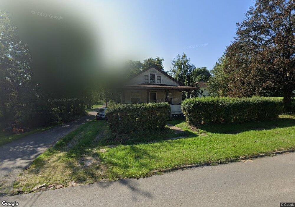
107 Harker St Mansfield, OH 44903
Estimated Value: $31,000 - $114,000
2
Beds
1
Bath
1,056
Sq Ft
$65/Sq Ft
Est. Value
About This Home
This home is located at 107 Harker St, Mansfield, OH 44903 and is currently estimated at $68,591, approximately $64 per square foot. 107 Harker St is a home located in Richland County with nearby schools including Goal Digital Academy, St. Peter's Elementary/Montessori School, and St. Peter's High School/Junior High.
Ownership History
Date
Name
Owned For
Owner Type
Purchase Details
Closed on
Apr 6, 2025
Sold by
Sams Freddie
Bought by
Jones Helen R and Kirkland Evelyn A
Current Estimated Value
Purchase Details
Closed on
Jun 4, 2020
Sold by
Estate Of Susie L Sams Moorman
Bought by
Jones Helen R and Kirkland Evelyn A
Create a Home Valuation Report for This Property
The Home Valuation Report is an in-depth analysis detailing your home's value as well as a comparison with similar homes in the area
Home Values in the Area
Average Home Value in this Area
Purchase History
| Date | Buyer | Sale Price | Title Company |
|---|---|---|---|
| Jones Helen R | $30,000 | Axxis Title | |
| Jones Helen R | $30,000 | Axxis Title | |
| Jones Helen R | -- | None Available |
Source: Public Records
Tax History Compared to Growth
Tax History
| Year | Tax Paid | Tax Assessment Tax Assessment Total Assessment is a certain percentage of the fair market value that is determined by local assessors to be the total taxable value of land and additions on the property. | Land | Improvement |
|---|---|---|---|---|
| 2024 | $596 | $12,720 | $1,400 | $11,320 |
| 2023 | $596 | $12,720 | $1,400 | $11,320 |
| 2022 | $680 | $12,170 | $1,270 | $10,900 |
| 2021 | $685 | $12,170 | $1,270 | $10,900 |
| 2020 | $700 | $12,170 | $1,270 | $10,900 |
| 2019 | $776 | $12,170 | $1,270 | $10,900 |
| 2018 | $765 | $12,170 | $1,270 | $10,900 |
| 2017 | $745 | $12,170 | $1,270 | $10,900 |
| 2016 | $793 | $12,570 | $2,020 | $10,550 |
| 2015 | $793 | $12,570 | $2,020 | $10,550 |
| 2014 | $227 | $12,570 | $2,020 | $10,550 |
| 2012 | $300 | $13,230 | $2,120 | $11,110 |
Source: Public Records
Map
Nearby Homes
- 452 Daisy St
- 156 Buckingham Ave Unit 158
- 526 Bowman St
- 371 Bell St
- 283 Bulkley Ave
- 0 Voegele Ave Unit Lot 6048, 6049, 6
- 743 Bowman St
- 426 Mcpherson St
- 169 W 5th St
- 346 Newman St
- 219 W 5th St
- 458 Wayne St
- 362-364 W 6th St
- 282 W 5th St
- 512 Burns St
- 311 Auburn St
- 0 Highway 30
- 82 N Adams St
- 406 Sherman Place
- 328 2nd Ave
- 472 N Mulberry St
- 470 N Mulberry St
- 473 Daisy St
- 468 N Mulberry St
- 463 Daisy St
- 102 Harker St
- 114 Harker St
- 120 Harker St
- 459 Daisy St
- 462 N Mulberry St
- 455 Daisy St
- 0 N Mulberry St
- 98 Harker St
- 466 N Mulberry St
- 504 N Mulberry St
- 495 Daisy St
- 506 N Mulberry St
- 479 N Mulberry St
- 458 N Mulberry St
- 130 Harker St