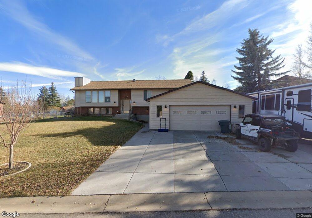
107 Johnston Ln Evanston, WY 82930
Estimated Value: $493,630 - $618,000
2
Beds
2
Baths
1,556
Sq Ft
$352/Sq Ft
Est. Value
About This Home
This home is located at 107 Johnston Ln, Evanston, WY 82930 and is currently estimated at $547,908, approximately $352 per square foot. 107 Johnston Ln is a home located in Uinta County with nearby schools including Evanston High School and Evanston Child Development Center.
Ownership History
Date
Name
Owned For
Owner Type
Purchase Details
Closed on
Feb 5, 2025
Sold by
Bateman Mary Kim
Bought by
Mary Kim Bateman Trust and Bateman
Current Estimated Value
Create a Home Valuation Report for This Property
The Home Valuation Report is an in-depth analysis detailing your home's value as well as a comparison with similar homes in the area
Home Values in the Area
Average Home Value in this Area
Purchase History
| Date | Buyer | Sale Price | Title Company |
|---|---|---|---|
| Mary Kim Bateman Trust | -- | None Listed On Document | |
| Mary Kim Bateman Trust | -- | None Listed On Document |
Source: Public Records
Tax History Compared to Growth
Tax History
| Year | Tax Paid | Tax Assessment Tax Assessment Total Assessment is a certain percentage of the fair market value that is determined by local assessors to be the total taxable value of land and additions on the property. | Land | Improvement |
|---|---|---|---|---|
| 2025 | $2,880 | $33,218 | $6,493 | $26,725 |
| 2024 | $2,880 | $42,379 | $8,657 | $33,722 |
| 2023 | $2,868 | $42,392 | $8,657 | $33,735 |
| 2022 | $2,472 | $36,305 | $7,245 | $29,060 |
| 2021 | $2,159 | $31,673 | $7,108 | $24,565 |
| 2020 | $1,964 | $28,826 | $7,108 | $21,718 |
| 2019 | $1,927 | $28,332 | $7,108 | $21,224 |
| 2018 | $0 | $29,008 | $8,594 | $20,414 |
| 2017 | $1,890 | $27,822 | $7,829 | $19,993 |
| 2016 | $1,875 | $27,571 | $7,805 | $19,766 |
| 2015 | -- | $27,520 | $7,805 | $19,715 |
| 2014 | -- | $27,133 | $0 | $0 |
Source: Public Records
Map
Nearby Homes
- 113 Butterfield Rd
- 240 Darby Ln
- 260 Darby Ln
- 149 Toponce Dr
- 66 Aspen Grove Dr W
- 132 Skyline Dr
- 106 Grandview
- 132 Silver Sage Dr
- 130 Silver Sage Dr
- 104 Windy Ridge Ct
- 132 Kings Ct
- 104 Canyon Hollow Dr
- 200 S Valley Lot 12 Dr
- 200 S Valley Lot 7 Dr
- 155 Highridge Point
- 46 City View Dr
- 413 Crane Ave
- 427 Thayer Cir
- 223 Barber Ave
- 221 Barber Ave
- 105 Johnston Ln
- 208 Hayden Ave
- 110 Butterfield Rd
- 110 Butterfield Rd Unit Hayden
- 104 Johnston Ln
- 210 Hayden Ave
- 106 Johnston Ln
- 106 Johnston Ln Unit Hayden
- 108 Butterfield Rd
- 103 Johnston Ln
- 106 Butterfield Rd
- 102 Johnston Ln
- 203 Hayden Ave
- 204 Hayden Ave
- 205 Hayden Ave
- 207 Hayden Ave
- 209 Washakie Dr
- 207 Washakie Dr
- 201 Hayden Ave
- 212 Hayden Ave