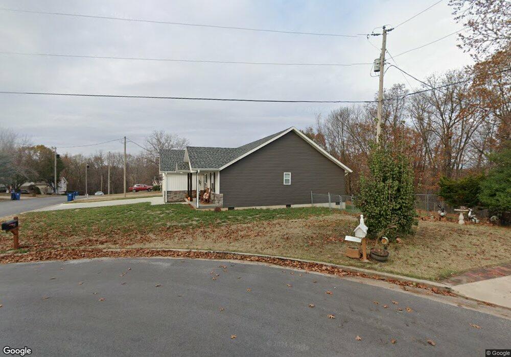
107 Kellie Ln Carl Junction, MO 64834
Estimated Value: $257,536 - $274,000
3
Beds
2
Baths
1,660
Sq Ft
$159/Sq Ft
Est. Value
About This Home
This home is located at 107 Kellie Ln, Carl Junction, MO 64834 and is currently estimated at $264,134, approximately $159 per square foot. 107 Kellie Ln is a home located in Jasper County with nearby schools including Carl Junction Primary School (K-1), Carl Junction Intermediate School, and Carl Junction Primary School (2-3).
Ownership History
Date
Name
Owned For
Owner Type
Purchase Details
Closed on
Jun 24, 2021
Sold by
Flipside Investment Llc
Bought by
Drenick Kathy J and Drenick Michael J
Current Estimated Value
Purchase Details
Closed on
Mar 4, 2020
Sold by
R H Karst Ret
Bought by
Filpside Investments Llc
Purchase Details
Closed on
Mar 28, 2007
Sold by
Brown Patricia A
Bought by
Karst Randy H and R H Karst Trust
Home Financials for this Owner
Home Financials are based on the most recent Mortgage that was taken out on this home.
Original Mortgage
$76,000
Interest Rate
6.3%
Mortgage Type
Purchase Money Mortgage
Create a Home Valuation Report for This Property
The Home Valuation Report is an in-depth analysis detailing your home's value as well as a comparison with similar homes in the area
Purchase History
| Date | Buyer | Sale Price | Title Company |
|---|---|---|---|
| Drenick Kathy J | -- | Waco Title | |
| Drenick Kathy J | -- | Waco Title | |
| Filpside Investments Llc | -- | None Available | |
| Karst Randy H | $5,067 | None Available |
Source: Public Records
Mortgage History
| Date | Status | Borrower | Loan Amount |
|---|---|---|---|
| Previous Owner | Karst Randy H | $76,000 |
Source: Public Records
Tax History
| Year | Tax Paid | Tax Assessment Tax Assessment Total Assessment is a certain percentage of the fair market value that is determined by local assessors to be the total taxable value of land and additions on the property. | Land | Improvement |
|---|---|---|---|---|
| 2025 | $1,743 | $33,230 | $1,640 | $31,590 |
| 2024 | $1,743 | $29,780 | $1,640 | $28,140 |
| 2023 | $1,753 | $29,780 | $1,640 | $28,140 |
| 2022 | $1,734 | $29,380 | $1,640 | $27,740 |
| 2021 | $691 | $13,640 | $1,640 | $12,000 |
| 2020 | $107 | $2,080 | $1,640 | $440 |
| 2019 | $102 | $2,080 | $1,640 | $440 |
| 2018 | $82 | $1,690 | $0 | $0 |
| 2017 | $83 | $1,690 | $0 | $0 |
| 2016 | $84 | $1,740 | $0 | $0 |
| 2015 | -- | $1,740 | $0 | $0 |
| 2014 | -- | $30,700 | $0 | $0 |
Source: Public Records
Map
Nearby Homes
- 123 Rocky Ln
- 25122 Gum Rd
- 121 Forest Dr
- 401 Dogwood Trails Loop
- 112 Red Oak Dr
- 6548 Mo-171
- 25452 Leffen Ln
- XXX Lone Elm
- Lot 1B Hwy 171 & Fir Rd
- Lot 1A Hwy 171 & Fir Rd
- 5981 Pearl St
- Lot 1 Hwy 171 & Fir Rd
- 2626 Joplin St
- LOT 4C Hwy 171 & Fir Rd Unit 4C
- Xxx Wall St
- 128 Par Ln
- 306 Lakeview Ln
- 232 Hickory Place
- Lot 14 Brenden Ln
- TBD Wall St
- 109 Kellie Ln
- 113 Randolph Dr
- 107 Randolph Dr
- 111 Kellie Ln
- 115 Randolph Dr
- 112 Kellie Ln
- 108 Randolph Dr
- 113 Kellie Ln
- 117 Randolph Dr
- 114 Kellie Ln
- 105 Randolph Dr
- 110 Randolph Dr
- 102 Randolph Dr
- 115 Kellie Ln
- 103 Randolph Dr
- 116 Kellie Ln
- 112 Randolph Dr
- 121 Randolph Dr
- 100 Randolph Dr
- 125 Rocky Ln
Your Personal Tour Guide
Ask me questions while you tour the home.