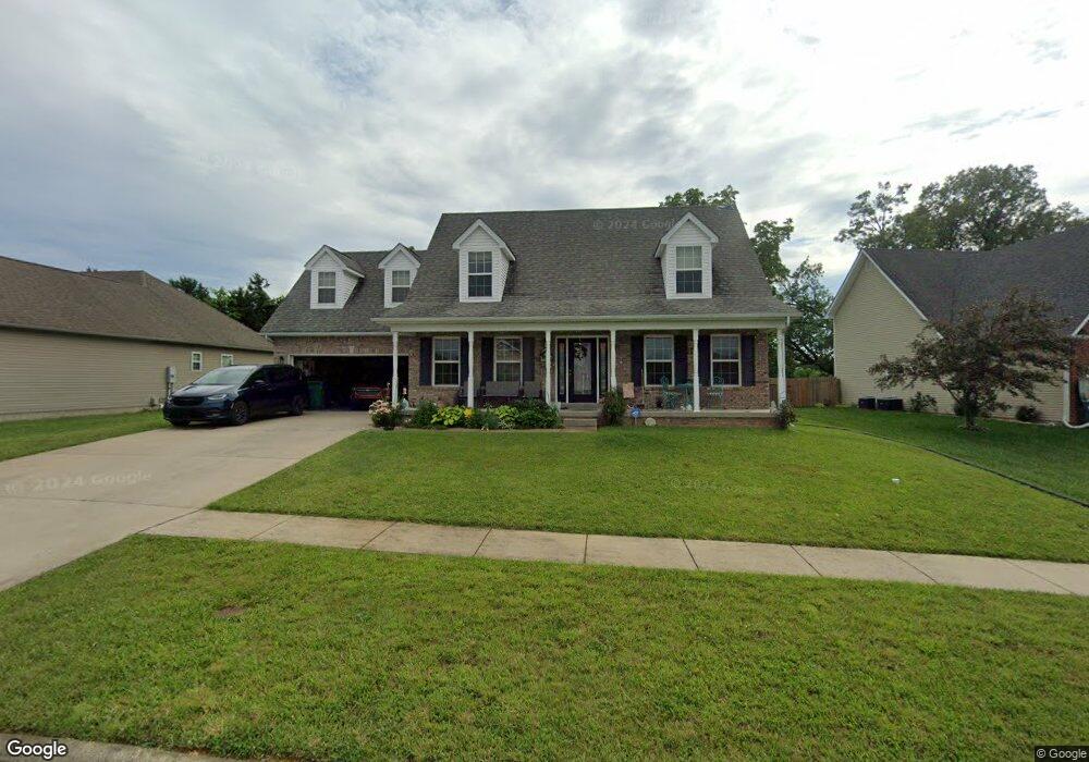
107 Maxwell Ct Vine Grove, KY 40175
Estimated Value: $319,551 - $362,000
3
Beds
3
Baths
2,012
Sq Ft
$171/Sq Ft
Est. Value
About This Home
This home is located at 107 Maxwell Ct, Vine Grove, KY 40175 and is currently estimated at $343,888, approximately $170 per square foot. 107 Maxwell Ct is a home located in Hardin County with nearby schools including Meadow View Elementary School, James T. Alton Middle School, and North Hardin High School.
Ownership History
Date
Name
Owned For
Owner Type
Purchase Details
Closed on
Mar 30, 2023
Sold by
Little Rex W and Little Nicole
Bought by
Little Rex W and Hong Nicole
Current Estimated Value
Purchase Details
Closed on
Jun 30, 2011
Sold by
W R Cecil Buiding Contractor Inc
Bought by
Little Rex W
Home Financials for this Owner
Home Financials are based on the most recent Mortgage that was taken out on this home.
Original Mortgage
$240,000
Interest Rate
4.63%
Mortgage Type
VA
Create a Home Valuation Report for This Property
The Home Valuation Report is an in-depth analysis detailing your home's value as well as a comparison with similar homes in the area
Home Values in the Area
Average Home Value in this Area
Purchase History
| Date | Buyer | Sale Price | Title Company |
|---|---|---|---|
| Little Rex W | -- | -- | |
| Little Rex W | -- | None Listed On Document | |
| Little Rex W | $240,000 | None Available |
Source: Public Records
Mortgage History
| Date | Status | Borrower | Loan Amount |
|---|---|---|---|
| Previous Owner | Little Rex W | $240,000 |
Source: Public Records
Tax History
| Year | Tax Paid | Tax Assessment Tax Assessment Total Assessment is a certain percentage of the fair market value that is determined by local assessors to be the total taxable value of land and additions on the property. | Land | Improvement |
|---|---|---|---|---|
| 2025 | $2,004 | $262,600 | $25,100 | $237,500 |
| 2024 | $2,026 | $262,600 | $25,100 | $237,500 |
| 2023 | $279 | $240,000 | $25,100 | $214,900 |
| 2022 | $2,266 | $240,000 | $25,100 | $214,900 |
| 2021 | $2,598 | $240,000 | $25,100 | $214,900 |
| 2020 | $2,623 | $240,000 | $25,100 | $214,900 |
| 2019 | $374 | $240,000 | $0 | $0 |
| 2018 | $2,568 | $240,000 | $0 | $0 |
| 2017 | $2,557 | $240,000 | $0 | $0 |
| 2016 | $374 | $240,000 | $0 | $0 |
| 2015 | $2,096 | $194,200 | $0 | $0 |
| 2012 | -- | $240,000 | $0 | $0 |
Source: Public Records
Map
Nearby Homes
- 143 Wiltshire Ave
- 119 Red Hawk Dr
- 208 Dixon Cir
- 214 Dixon Cir
- 210 Dixon Cir
- 907 Rhonda Ct
- 1165 N Logsdon Pkwy
- 1362 Darlene Cir
- Lot 37 Taft Trail
- Lot 36 Taft Trail
- 1433 Crestview Dr
- 1544 Willow Way
- 775 Cherrywood Dr
- 1601 Birch Ct
- 1104 Ellen Dr
- 1393 Kingswood Way
- 1058 Scenic Dr
- 1746 Holly Ct
- 1202 Clear Ridge Ln
- 1204 Clear Ridge Ln
Your Personal Tour Guide
Ask me questions while you tour the home.