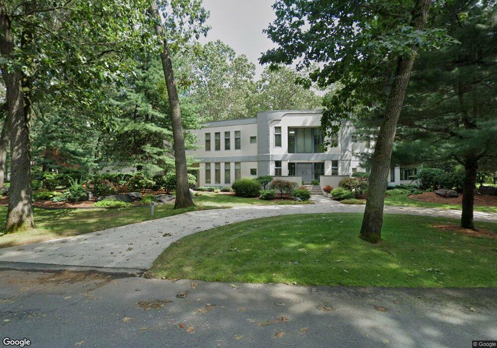
107 Normandy Rd Longmeadow, MA 01106
Estimated Value: $1,234,922 - $1,525,000
4
Beds
7
Baths
9,300
Sq Ft
$146/Sq Ft
Est. Value
About This Home
This home is located at 107 Normandy Rd, Longmeadow, MA 01106 and is currently estimated at $1,355,481, approximately $145 per square foot. 107 Normandy Rd is a home located in Hampden County with nearby schools including Blueberry Hill, Williams Middle School, and Longmeadow High School.
Ownership History
Date
Name
Owned For
Owner Type
Purchase Details
Closed on
May 13, 2022
Sold by
Goodman Alan R
Bought by
Gunay Ahmet and Gunay Canan
Current Estimated Value
Home Financials for this Owner
Home Financials are based on the most recent Mortgage that was taken out on this home.
Original Mortgage
$847,500
Outstanding Balance
$795,683
Interest Rate
4.67%
Mortgage Type
Purchase Money Mortgage
Estimated Equity
$559,798
Purchase Details
Closed on
Apr 27, 2006
Sold by
Goodman Alan R and Goodman Joan F
Bought by
Goodman Alan R
Create a Home Valuation Report for This Property
The Home Valuation Report is an in-depth analysis detailing your home's value as well as a comparison with similar homes in the area
Home Values in the Area
Average Home Value in this Area
Purchase History
| Date | Buyer | Sale Price | Title Company |
|---|---|---|---|
| Gunay Ahmet | $1,130,000 | None Available | |
| Goodman Alan R | -- | -- | |
| Goodman Alan R | -- | -- |
Source: Public Records
Mortgage History
| Date | Status | Borrower | Loan Amount |
|---|---|---|---|
| Open | Gunay Ahmet | $847,500 | |
| Previous Owner | Goodman Alan R | $750,000 | |
| Previous Owner | Goodman Alan R | $987,250 |
Source: Public Records
Tax History
| Year | Tax Paid | Tax Assessment Tax Assessment Total Assessment is a certain percentage of the fair market value that is determined by local assessors to be the total taxable value of land and additions on the property. | Land | Improvement |
|---|---|---|---|---|
| 2025 | $24,463 | $1,158,300 | $270,400 | $887,900 |
| 2024 | $23,954 | $1,158,300 | $270,400 | $887,900 |
| 2023 | $25,450 | $1,110,400 | $194,100 | $916,300 |
| 2022 | $25,638 | $1,040,500 | $194,100 | $846,400 |
| 2021 | $25,460 | $1,019,900 | $207,900 | $812,000 |
| 2020 | $23,610 | $975,200 | $223,400 | $751,800 |
| 2019 | $23,493 | $975,200 | $223,400 | $751,800 |
| 2018 | $24,097 | $990,900 | $307,400 | $683,500 |
| 2017 | $24,080 | $1,021,200 | $307,400 | $713,800 |
| 2016 | $23,160 | $951,900 | $286,700 | $665,200 |
| 2015 | $22,418 | $949,100 | $283,900 | $665,200 |
Source: Public Records
Map
Nearby Homes
- 153 Porter Lake Dr Unit 153
- 114 Park Dr
- 59 Lawrence Dr
- 55 Fernleaf Ave
- 1155 Dickinson St
- 58 Englewood Rd
- 112 Grassy Gutter Rd
- 32 Edgewood Ave
- 50 Elmwood Ave
- 96 Firglade Ave
- 12 Carroll St
- 104 Appleton St
- 124 Tecumseh Dr
- 58 Appleton St
- 283 Longhill St
- 115 Tiffany St
- 332-334 Forest Park Ave
- 35 Spruceland Ave
- 20 Kimberly Cir
- 132 Carroll St
- 107 Normandy Rd
- 19 Brittany Rd
- 129 Normandy Rd
- 350 Converse St
- 27 Brittany Rd
- 116 Normandy Rd
- 362 Converse St
- 134 Normandy Rd
- 95 Normandy Rd
- 100 Normandy Rd
- 33 Brittany Rd
- 28 Brittany Rd
- 370 Converse St
- 29 Rugby Rd
- 36 Brittany Rd
- 206 Colony Rd
- 45 Brittany Rd
- 341 Converse St
- 82 Normandy Rd
- 359 Converse St
Your Personal Tour Guide
Ask me questions while you tour the home.